Spencers Wood
Spencers Wood is a village in the civil parish of Shinfield, Berkshire, England, 4 miles (6.4 km) south of Reading. The village of Three Mile Cross adjoins it to the north. To the west lies the village of Grazeley.
| Spencers Wood | |
|---|---|
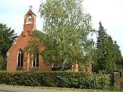
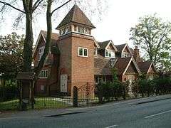 The Chapel, Spencers Wood | |
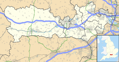 Spencers Wood Location within Berkshire | |
| Population | 2011 Census |
| Civil parish | |
| Unitary authority |
|
| Ceremonial county | |
| Region | |
| Country | England |
| Sovereign state | United Kingdom |
| Post town | Reading |
| Postcode district | RG7 |
| Dialling code | 0118 |
| Police | Thames Valley |
| Fire | Royal Berkshire |
| Ambulance | South Central |
| UK Parliament | |
History

The earliest confirmed reference to the name 'Spencers Wood' dates from 1500, when a man named John Blunt left 3s 4d for the repair of a road through the wood called Spencers Wood.[1] The name of the wood may derive from the le Despencer family — a Norman family – who held half a knight's fee in Swallowfield in the 13th century,[2] but there is no confirmed documentary evidence for this. Before that, the area was probably part of the Royal Forest (Windsor Forest).
By 1761 when John Roque published his map of Berkshire, there was no wood as such.[3] There was instead a common – one of a series of commons and greens south of Reading – and on the OS maps of the later nineteenth century, the area is referred to as 'Spencerswood Common', even though the common had by then been enclosed.
The area from Three Mile Cross to the boundary with Hampshire beyond Riseley, including part of Swallowfield – Part Lane in Swallowfield marks the partition – was until 1844 a detached portion of Wiltshire. (In the 13th century, Spencers Wood was administered by William Longespée, Earl of Salisbury and his court in Amesbury.[4]) On 20 October 1844 in the Counties (Detached Parts) Act 1844 the area became part of Berkshire.
Around 1816 a non-conformist chapel (Congregational) was built near the corner of Hyde End Road and Basingstoke Road, set back from the road near the fourth mile post from Reading on the Reading to Basingstoke turnpike. In 1905 it was replaced by a new larger church (nearer the road), which, due to falling attendances, closed in 1999 and was subsequently converted into apartments. In the late nineteenth century this was the only church in the village and, with its Institute serving as a village hall, tennis courts etc, provided a focus for social activity in the village.[5]
After the common was enclosed
By 1864 all of the common land had been enclosed. On the west side of Basingstoke Road, north of Beech Hill Road, two gentlemen established country estates: the local philanthropist Frederick Allfrey, who built Stanbury (where Wellington Court now is) and William Merry, who was a County magistrate and a visiting magistrate to Reading Gaol, as well as Secretary at War Lord Palmerston's private secretary from 1812 to 1828. The open area in front of Merry's house, Highlands, is still known as 'the Common'. The east side of Basingstoke Road was divided among many owners, who progressively sold off the land for development.[6]
By 1880, Spencers Wood had become a thriving village with a population of 600, of whom 200 were children. Most of the adults worked in the fields or were in domestic service. Victorian and Edwardian style houses were built along the Basingstoke Road using bricks baked at the local Swain family kiln. The Square became the heart of the village during this building period, and many of these houses still stand.[7]
In 1990 Frederick Allfrey built an Infants' School opposite the end of Hyde End Road. It closed as a school in 1915, as both Lambs Lane and Ryeish Green schools were open by then. The building continued to be used for educational purposes, but since the 1970s has been used as a library.[8]
In spite of its growth, Spencers Wood was still split between the ecclesiastical parishes of Shinfield, Swallowfield and Grazeley. This changed in 1908 when the Church of St Michael and All Angels was consecrated. The ecclesiastical parish of Spencers Wood was created five years later, although some parts of the village remained in the parish of Grazeley. In 2004 the parishes of Spencers Wood and Grazeley with Beech Hill were united under a single PCC, and the same year became part of the United Benefice of Loddon Reach.[9]
Also in 1908, Lambs Lane school opened, ending the need for older children to walk to Swallowfield's Russell Hall, Shinfield or Grazeley School.[10]
The Arts and Crafts-style Village Hall was opened in 1911 and is run by a board of trustees on behalf of the village inhabitants.[11]
World War Two
Spencers Wood, being a rural community, was unaffected by the Blitz. Few German bombs fell in the area, which was just as well as the village has no air-raid shelters. One German plane was shot down locally.
Rationing also had little effect on the village as the majority of villagers were too poor to notice a real reduction in goods. Food was grown and caught locally as part of the dig for victory programme and the black-market was able to supply all excess demand.
The main impact of the war was the influx of people. Two coaches of evacuees arrived in the village in September 1939. Evacuee children and local children were educated separately until Christmas 1939. Canadian forces were stationed at Stanbury (where Wellington Court now is) for a while, and a small POW camp was opened there after the Canadians relocated. Some POWs helped on the local farms. The village hall served as the Local Defence Volunteers headquarters. Basingstoke Road was the main road to Aldershot, and frequent troop convoys ran through the village.
After the war, many soldiers, evacuees and prisoners of war decided to settle in the village.
Recent history
The first street lighting in the village was installed after the war.
In 1954, Spencers Wood Women's Institute was formed. It was quite successful, with 60 members at its height. It closed in the mid-1980s.
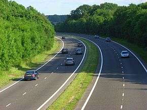
In the 1960s, the M4 Motorway was built and became a man-made barrier between the village and Reading. In the 1980s, the A33 Swallowfield Bypass severed roads to the village of Grazeley lying to the East.
Despite local opposition, many new houses have been constructed in the village in recent years.
Village Services
- Double's Garage is a petrol station and car mechanic on the Basingstoke Road. It is a business that has been family owned for over 100 years, which started out as a blacksmith and farrier in The Square, the centre of the village. The original site of the blacksmith's forge has been replaced by modern houses (Anvil Close).
- Stagecoach provides a regular bus service (No 7) through the village, with buses every hour Mondays to Saturdays. They are the latest of a plethora of bus companies to serve the village, which started with Cordery's Garage. The prices of the earliest return tickets to Reading were 11d (approx 5p), although for just over double (2 shillings, exactly 10p) a weekly ticket was available. Reading Buses operate a service to the village on some weekday evenings and Sundays (also the number 7).
- The bakery, now operated by Warings, has always been a bakers. Although it is now part of a chain, the bread is still baked here. Originally, it was one of three bakeries in the village.
- The local library is part of Wokingham Borough Council's Libraries. The building was originally an infants' school (opened in 1890).[12]
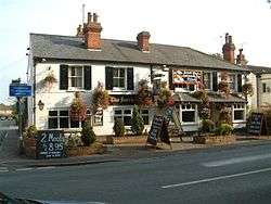
- The local pub is called The Farriers' Arms, although it was briefly called The Cygnet when it was purchased by the owner of The Swan (a pub in neighbouring Three Mile Cross). Before the Swallowfield Bypass was built, it was a popular place for coaches to stop on their way to the south coast, so much so that reservations were required. It is a very old business, although originally only a beer house. A full licence was granted after the First World War. In recent times, it has expanded to incorporate two adjacent cottages, making it significantly larger than the original beer house. Originally there were many more pubs in Spencers Wood.
- The Hop Inn is the local off-licence. The building was originally a pub called The Cricketers, although it was one of the village butchers for a while.
- There is an Indian restaurant, Miah's, in the village. It is not the first Indian business to serve Spencers Wood, an Indian tablecloth and silk tie trader served the village before World War Two.
- A chemist now occupies the building that was Harrisons Grocery Store and Provision Shop. During World War One, it was known as Farleys.
- Healthcare is provided for the village by Swallowfield Medical Practice.[13]
- The Grovelands Garden Centre was a family-run business until 2006 when Dobbies Garden Centres took it over. Dobbies has since been bought by Tesco.
- The village post office is on the Basingstoke Road. It has been a post office since 1885, and was a manual telephone exchange until 1934. The oldest surviving postbox in the village dates from King George V's reign. In November 1992 the post office was the scene of a bloodless armed robbery, but no-one was arrested for the crime. At the end of 2015, the Postmaster enlarged the store and took on a One Stop franchise.
- Two hairdressers serve the village, Chandlers and Blissimi. Blissimi opened in 2015 in a new building that replaced a house that had until the previous year been Anita's hairdressers. It had earlier been a harnessmaker's.
- There was a builder's merchant, Meakin Building Supplies Ltd, in Lambs Lane from 1981 to 2013, having previously operated from that site as a haulage company, Meakin Transport. The haulage company moved to Back Lane several years after the builder's merchant began to thrive. The haulage company site in Back Lane was originally known as Judd's yard and was previously a sawmill.
- The village has two areas with allotments.
References
- Spencers Wood Local History Group, More from Our Village of Spencers Wood (2016)
- VCH Berkshire: Swallowfield
- John Roque, A Topographical Survey of the County of Berks (1761).
- VCH Berkshire: Swallowfield
- More from Our Village of Spencers Wood
- More from Our Village of Spencers Wood
- More from Our Village of Spencers Wood
- More from Our Village of Spencers Wood
- More from Our Village of Spencers Wood
- Spencers Wood Local History Group, The History of Lambs Lane School, 1908-2008
- More from Our Village of Spencers Wood
- More from Our Village of Spencers Wood
- https://www.swallowfieldmedicalpractice.co.uk
External links
![]()