Southwest Harbor (CDP), Maine
Southwest Harbor is a census-designated place (CDP) in the town of Southwest Harbor in Hancock County, Maine, United States. The CDP population was 720 at the 2010 census,[1] out of 1,764 people in the town as a whole.
Southwest Harbor, Maine | |
|---|---|
 Southwest Harbor  Southwest Harbor | |
| Coordinates: 44°16′46″N 68°19′33″W | |
| Country | United States |
| State | Maine |
| County | Hancock |
| Town | Southwest Harbor |
| Area | |
| • Total | 1.4 sq mi (3.5 km2) |
| • Land | 1.4 sq mi (3.5 km2) |
| • Water | 0.0 sq mi (0.0 km2) |
| Elevation | 46 ft (14 m) |
| Population (2010) | |
| • Total | 720 |
| • Density | 535/sq mi (206.4/km2) |
| Time zone | UTC-5 (Eastern (EST)) |
| • Summer (DST) | UTC-4 (EDT) |
| ZIP code | 04679 |
| Area code(s) | 207 |
| FIPS code | 23-72830 |
| GNIS feature ID | 2630701 |
Geography
The Southwest Harbor CDP is the main village within the town of Southwest Harbor on Mount Desert Island. It is situated primarily around the tidal cove of Southwest Harbor and extends north to Norwood Cove. Both inlets are located at the southern end of Somes Sound, an arm of the Gulf of Maine.[2]
Maine State Route 102 passes through Southwest Harbor, leading southwest 2.5 miles (4.0 km) to Tremont and north 6 miles (10 km) to Somesville at the north end of Somes Sound. Route 102A splits east from Route 102 at the south end of the Southwest Harbor CDP, and makes a loop through Seawall and Bass Harbor, reaching Tremont in 7 miles (11 km).
According to the United States Census Bureau, the Southwest Harbor CDP has an area of 1.4 square miles (3.5 km2), all of it land.[1]
References
- "Geographic Identifiers: 2010 Demographic Profile Data (G001): Southwest Harbor CDP, Maine". American Factfinder. U.S. Census Bureau. Retrieved July 11, 2017.
- "TIGERweb: Southwest Harbor CDP". Geography Division, U.S. Census Bureau. Retrieved July 11, 2017.
Municipalities and communities of Hancock County, Maine, United States | ||
|---|---|---|
| City | 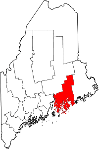 Hancock County map | |
| Towns |
| |
| Unorganized territories | ||
| CDPs | ||
| Other villages |
| |