South Delhi
South Delhi is an administrative district of the National Capital Territory of Delhi in India.
South Delhi | |
|---|---|
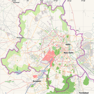 South Delhi Location in Delhi, India | |
| Coordinates: 28.5549°N 77.1919°E | |
| Country | |
| State | Delhi |
| Headquarters | Saket |
| Government | |
| • Body | GNCT of Delhi |
| • Member of Parliament | Ramesh Bidhuri |
| Area | |
| • Total | 250 km2 (100 sq mi) |
| Elevation | 241 m (791 ft) |
| Population (2011) | |
| • Total | 2,731,929 |
| • Density | 11,000/km2 (28,000/sq mi) |
| Languages | |
| • Official | Hindi, English, Punjabi, Urdu |
| Time zone | UTC+5:30 (IST) |
| Nearest city | Faridabad Gurgaon |
| Lok Sabha constituency | South Delhi |
| Civic agency | South Delhi Municipal Corporation Mayor = Ms. Sunita Kangra |

It is bounded by the Yamuna River to the east, the districts of New Delhi to the north, Faridabad District of Haryana state to the southeast, Gurgaon District of Haryana to the southwest, and South West Delhi to the west.
South Delhi has a population of 2,731,929 (2011 census), and an area of 250 square kilometres (97 sq mi), with a population density of 9,034 persons per km² (23,397 persons per mi²).
Administratively, the district is divided into three subdivisions, Saket, Hauz Khas, and Mehrauli.[1]
The division shown on the map bears only administrative significance, as to the common citizen, broadly speaking Delhi is vaguely ring-like, having five regions, namely North, West, South, East and Central. The usage of the term South Delhi in day-to-day life expands from Delhi's IGI Airport in the South West to the river Yamuna in the South East, a region protruding into administrative South West Delhi district.
Demographics
According to the 2011 census South Delhi has a population of 2,731,929, roughly equal to the nation of Jamaica[2] or the US state of Nevada.[3] This gives it a ranking of 144th in India (out of a total of 640). The district has a population density of 10,935 inhabitants per square kilometre (28,320/sq mi). Its population growth rate over the decade 2001-2011 was 20.59%. South Delhi has a sex ratio of 859 females for every 1000 males, and a literacy rate of 87.03%.
| Historical population | ||
|---|---|---|
| Year | Pop. | ±% p.a. |
| 1961 | 314,789 | — |
| 1971 | 589,956 | +6.48% |
| 1981 | 986,856 | +5.28% |
| 1991 | 1,501,881 | +4.29% |
| 2001 | 2,267,023 | +4.20% |
| 2011 | 2,731,929 | +1.88% |
| source:[4] | ||
Importance
South Delhi is a vast area in the city of Delhi and contains many significant locations. Of the eleven 'historical cities' of Delhi, four, viz. Rai Pithora (1st), Mehrauli (2nd), Siri (including Hauz Khas) (3rd) and Tughlaqabad (5th) fall in the South Delhi district.
This district has thriving medieval era colonies or sarais, which now are severely congested and under neglect. These include Chirag Delhi, Kalu Sarai, Jia Sarai, Ber Sarai, Lado Sarai, Katwaria Sarai, Yusuf Sarai, Hauz Khas Village, Munirka, Kotla Mubarakpur, Begumpur, Saidulajaib, Mohammadpur, Khirki, Govindpuri, Adhchini, Chhattarpur Village, Badarpur on historic Grand Trunk Road, Aayaa Nagar, Maandi Village, Dera Village, etc.
Other than history, the region has economic and educational importance too. In Nehru Place, it has Asia's largest computer market and IT market of the city. The Indian Institute of Technology Delhi, All India Institute of Medical Sciences and National Institute of Fashion Technology, three of the country's premier institutes in the field of technology, medicine and fashion respectively lie in the Hauz Khas locality of South Delhi. The Indian Institute of Foreign Trade of Delhi is located in the Qutub Institutional Area of South Delhi. Sangam Vihar is also located in South Delhi, which has the highest population in the State. The top Central University Jamia Millia Islamia is situated at Jamia Nagar area of South Delhi.
The administrative district had 20% Green Cover, as of 2009. It has several spacious green parks, wildlife sanctuary, biodiversity parks, and green belts. Deer Park and Rose Garden in Hauz Khas, Asola Wildlife Sanctuary close to Delhi's southern border on the Aravallis foothills are few examples. It has a good mix of concrete and greens.
Many important city roads such as Mehrauli-Gurgaon Road, Mehrauli-Badarpur Road, Aurobindo Marg, August Kranti Marg, Press Enclave Road, etc. fall in this district, while arterial roads like Inner Ring Road, Outer Ring Road and NH-2 pass through it.
Jahaz Mahal, Zafar Mahal, Tughlaqabad, Hauz Khas Complex, Bijay Mandal, Qutub Minar, Mehrauli Archaeological Park, and the Safdarjung Tomb comprise some of South Delhi's most scenic heritage sites.
Real Estate
Most of the affluent and upmarket residential areas of South Delhi were established in the early 1960's. Today, Colonies such as Greater Kailash, Defense Colony, South Extension, Green Park, Neeti Bagh, Gulmohar Park, Hauz Khas, Safdarjung Development Area, Vasant Vihar,Sarvodaya Enclave, Anand Niketan and Panchsheel Park are among the most expensive pin codes of New Delhi. All these colonies are categorized in either category 'A' or category 'B' which highlights the fact that residents of these colonies come under the very affluent and upper-middle-class sections of the society. Newly built builder floors and independent villas sell for as high as INR 10-80 crores in South Delhi. All these colonies are 'planned colonies' and therefore have proper connectivity to major roads and metro networks. They all also host their own markets such as Greater Kailash-1, M block Market, Green Park Market, Hauz Khas village area, South Extension Market and Defense Colony Market which are considered to be the poshest markets of Delhi. There are also numerous dedicated recreational areas around these colonies which is a luxury in today's heavily urbanized and congested New Delhi.
Life
South district is considered to be the most affluent of all residential districts of Delhi, other than the districts falling under Lutyen's Delhi, viz. New Delhi and Central Delhi. With upscale areas like Greater Kailash, South Extension, Jangpura, Kailash East, Saket, Sainik Farm, Chittaranjan Park, Malviya Nagar, Alaknanda, Hauz Khas, Green Park, Defence Colony, Lajpat Nagar, Kalkaji, New Friends Colony, Sarita Vihar, Jasola Vihar, Gulmohar Park, Gulmohar enclave, and Vasant Kunj, it has the highest land prices outside Lutyen's Zone in Delhi. Urban villages in South Delhi, like Hauz Khas Village, and Shahpur Jat have become hub for designer boutiques, restaurants and art galleries and design studios.[5][6]
Many renowned markets of Delhi such as Sarojini Nagar Market, Green Park Market, Lajpat Nagar Market, South Extension, Kotla Mubarakpur, M-block Market, etc. and malls such as Ansal Plaza, DLF, MGF Metropolitan, Select Citywalk, Malviya Nagar, etc. are located in South Delhi.
See also
- Districts of Delhi
- Hauz Khas
- Moti Bagh
- Jahanpanah
- Dwarka
- New Friends Colony
- Shaheen Bagh
- Rajpath
- Green Park
Nearby
- Siri Fort
- Lajpat Nagar Central Market
- Sarojini Nagar
- INA
References
- Organisational Structure Official website.
- US Directorate of Intelligence. "Country Comparison:Population". Retrieved 1 October 2011.
Jamaica 2,868,380 July 2011 est
- "2010 Resident Population Data". U. S. Census Bureau. Retrieved 30 September 2011.
Nevada 2,700,551
- Decadal Variation In Population Since 1901
- "Art edges out history in Delhi's ancient Lado Sarai village". The Times Of India. 11 April 2013. Retrieved 16 June 2013.
- "Delhi's soho". Hindustan Times. 15 June 201. Archived from the original on 24 June 2013. Retrieved 16 June 2013.
External links
Places adjacent to South Delhi | ||||||||||
|---|---|---|---|---|---|---|---|---|---|---|
| ||||||||||