East Delhi
East Delhi (a.k.a. Trans Yamuna) is an administrative district of the National Capital Territory of Delhi in India. It is bounded by the Yamuna River on the west, North East Delhi to the north, Ghaziabad District of Uttar Pradesh state to the east, and Gautam Buddha Nagar District of Uttar Pradesh to the south.
East Delhi | |
|---|---|
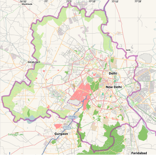 East Delhi Location in Delhi, India | |
| Coordinates: 28°38′24″N 77°17′24″E | |
| Country | |
| State | Delhi |
| Headquarters | Preet Vihar |
| Government | |
| • Body | East Delhi Municipal Corporation Mayor = Smt. Anju |
| Population (2011) | |
| • Total | 1,709,346 |
| Languages | |
| • Official | Hindi, English, Urdu, Punjabi |
| Time zone | UTC+5:30 (IST) |
| Nearest city | Noida, Ghaziabad |
| Lok Sabha constituency | East Delhi |
| Civic agency | East Delhi Municipal Corporation (EDMC) |

East Delhi has a population of 1,709,346 (2011 census) and an area of 64 km², with a population density of 22,639 persons per km².
Administratively, the district is divided into three subdivisions: Gandhi Nagar, Preet Vihar, and Shahdara
EDMCis the civic authority of this region. Smt. Anju[1] is the current mayor of EDMC.
Demographics
According to the 2011 census East Delhi has a population of 1,709,346, roughly equal to the nation of The Gambia[2] or the US state of Nebraska.[3] This gives it a ranking of 284th in India (out of a total of 640). The district has a population density of 26,683 inhabitants per square kilometre (69,110/sq mi) . Its population growth rate over the decade 2001-2011 was 16.68%. East Delhi has a sex ratio of 883 females for every 1000 males, and a literacy rate of 88.75%.
Visitor attractions
- Akshardham Temple (one of the biggest temples in the world)
- Cross River Mall
- Gandhi Nagar Market
- Lal Quarter Market, Krishna Nagar
- Laxmi Nagar Market
- Mahagun Mall
- Shakarpur Main Market
- V3S Mall
- Yamuna Sports Complex
- Ramesh Park Export Market
Health institutions
- Chacha Nehru Bal Chikitsalya, Geeta Colony
- Delhi State Cancer Institute
- Dr. Hedgewar Arogya Sansthan situated at karkardooma
- Guru Tegh Bahadur Hospital (or GTBH or GTB Hospital) is a 1500-bed government hospital situated at Dilshad Garden and is affiliated to and acts as the teaching hospital of University College of Medical Sciences.
- Institute of Human Behaviour & Allied Sciences (IHBAS)
- Jain Neuro Center
- Lal Bahadur Shastri Hospital, Khichri Pur
- Makkar Super Speciality Hospital, Khureji Road
- Max Super Speciality Hospital, Patparganj
- Pushpanjali Hospital
- Vivekanad Yogashram Hospital, Khureji Khas
- Women wellness Clinic (Gynecology)
- WHO Dispensary (Bank Enclave)
- Government of India Dispensary (Jagat Ram Park)
- Walia Nursing & Maternity Home , Main Vikas Marg, Laxmi Nagar (Delhi)
Major localities
- Azad Nagar
- Anand Vihar Colony
- Babarpur
- Bahubali Enclave
- Balbir Nagar
- Dallupura
- Dayanand Vihar
- Dilshad colony
- Dilshad Garden
- Durga Puri
- East Vinod Nagar
- Gandhi Nagar
- Ganesh Nagar
- Gazipur
- Geeta Colony
- Gujarat Vihar
- Hans Apartment
- Jagatpuri
- Jyoti Nagar(east)
- Jyoti Nagar(west)
- Kanti nagar
- Kalyan Puri
- Khureji khas
- Krishna Nagar
- Laxmi Nagar (Delhi)
- Mandaoli
- Mandawali
- Mayur Vihar
- Mayur Vihar Phase - 3
- New Ashok Nagar
- New Gobind Pura
- New Kondli
- New Layalpur Colony
- Nirman Vihar
- Old anarkali
- Pandav Nagar
- Patparganj (I.P.Extension)
- Preet Vihar
- Puspanjali
- Saini Enclave
- Savita Vihar
- Shahdara
- Shakarpur
- Shreshtha vihar
- Surajmal Vihar
- Surya Niketan
- Tahirpur
- Trilokpuri
- Vasundhara Enclave
- Vishwas Nagar
- Vivek Vihar
- Vigyan Vihar
- West Vinod Nagar
- Yamuna Vihar
- Yojana Vihar
- Yojana Vihar
- kirari suleman nagar
See also
- Districts of Delhi
- Mayur Vihar
- Babarpur Extension Welfare Society (Regd 1982) Oldest RWA in East Delhi. Famous Youth and dynamic Leader Mukesh Dixit is President of this society.
References
- "East Delhi Municipal Corporation". www.mcdonline.gov.in. Retrieved 3 December 2019.
- US Directorate of Intelligence. "Country Comparison:Population". Retrieved 1 October 2011.
Gambia, The 1,797,860 July 2011 est.
- "2010 Resident Population Data". U. S. Census Bureau. Archived from the original on 19 October 2013. Retrieved 30 September 2011.
Nebraska 1,826,341
External links
Places adjacent to East Delhi | ||||||||||
|---|---|---|---|---|---|---|---|---|---|---|
| ||||||||||