Soho Line
The Sŏho Line is an electrified 762 mm (2 ft 6 in) narrow gauge railway line of the Korean State Railway in Hamhŭng-si, North Korea, running from Hamhŭng to Hŭngnam and Sŏho.[1]
| Sŏho Line | ||||||||||||||||||||||||||||||||||||||||||||||||||||||||||||||||||||||||||||||||||||||||||||||||||||||||||||||||||||||||||||||||||||||||||||||||||||||||||||||||||||||||||||||||||||||||||||||||||||||||||||||||||||||||||||||||||||||||||||||||||||||||||||||||||||||||
|---|---|---|---|---|---|---|---|---|---|---|---|---|---|---|---|---|---|---|---|---|---|---|---|---|---|---|---|---|---|---|---|---|---|---|---|---|---|---|---|---|---|---|---|---|---|---|---|---|---|---|---|---|---|---|---|---|---|---|---|---|---|---|---|---|---|---|---|---|---|---|---|---|---|---|---|---|---|---|---|---|---|---|---|---|---|---|---|---|---|---|---|---|---|---|---|---|---|---|---|---|---|---|---|---|---|---|---|---|---|---|---|---|---|---|---|---|---|---|---|---|---|---|---|---|---|---|---|---|---|---|---|---|---|---|---|---|---|---|---|---|---|---|---|---|---|---|---|---|---|---|---|---|---|---|---|---|---|---|---|---|---|---|---|---|---|---|---|---|---|---|---|---|---|---|---|---|---|---|---|---|---|---|---|---|---|---|---|---|---|---|---|---|---|---|---|---|---|---|---|---|---|---|---|---|---|---|---|---|---|---|---|---|---|---|---|---|---|---|---|---|---|---|---|---|---|---|---|---|---|---|---|---|---|---|---|---|---|---|---|---|---|---|---|---|---|---|---|---|---|---|---|---|---|---|---|---|---|---|---|---|---|---|---|---|
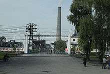
.jpg) A narrow-gauge passenger train on the Sŏho Line. | ||||||||||||||||||||||||||||||||||||||||||||||||||||||||||||||||||||||||||||||||||||||||||||||||||||||||||||||||||||||||||||||||||||||||||||||||||||||||||||||||||||||||||||||||||||||||||||||||||||||||||||||||||||||||||||||||||||||||||||||||||||||||||||||||||||||||
| Overview | ||||||||||||||||||||||||||||||||||||||||||||||||||||||||||||||||||||||||||||||||||||||||||||||||||||||||||||||||||||||||||||||||||||||||||||||||||||||||||||||||||||||||||||||||||||||||||||||||||||||||||||||||||||||||||||||||||||||||||||||||||||||||||||||||||||||||
| Native name | 서호선 (西湖線) | |||||||||||||||||||||||||||||||||||||||||||||||||||||||||||||||||||||||||||||||||||||||||||||||||||||||||||||||||||||||||||||||||||||||||||||||||||||||||||||||||||||||||||||||||||||||||||||||||||||||||||||||||||||||||||||||||||||||||||||||||||||||||||||||||||||||
| Type | Light rail, Passenger rail Regional rail | |||||||||||||||||||||||||||||||||||||||||||||||||||||||||||||||||||||||||||||||||||||||||||||||||||||||||||||||||||||||||||||||||||||||||||||||||||||||||||||||||||||||||||||||||||||||||||||||||||||||||||||||||||||||||||||||||||||||||||||||||||||||||||||||||||||||
| Status | Operational | |||||||||||||||||||||||||||||||||||||||||||||||||||||||||||||||||||||||||||||||||||||||||||||||||||||||||||||||||||||||||||||||||||||||||||||||||||||||||||||||||||||||||||||||||||||||||||||||||||||||||||||||||||||||||||||||||||||||||||||||||||||||||||||||||||||||
| Termini | Hamhŭng Sŏho, Hŭngnam | |||||||||||||||||||||||||||||||||||||||||||||||||||||||||||||||||||||||||||||||||||||||||||||||||||||||||||||||||||||||||||||||||||||||||||||||||||||||||||||||||||||||||||||||||||||||||||||||||||||||||||||||||||||||||||||||||||||||||||||||||||||||||||||||||||||||
| Stations | 11 | |||||||||||||||||||||||||||||||||||||||||||||||||||||||||||||||||||||||||||||||||||||||||||||||||||||||||||||||||||||||||||||||||||||||||||||||||||||||||||||||||||||||||||||||||||||||||||||||||||||||||||||||||||||||||||||||||||||||||||||||||||||||||||||||||||||||
| Operation | ||||||||||||||||||||||||||||||||||||||||||||||||||||||||||||||||||||||||||||||||||||||||||||||||||||||||||||||||||||||||||||||||||||||||||||||||||||||||||||||||||||||||||||||||||||||||||||||||||||||||||||||||||||||||||||||||||||||||||||||||||||||||||||||||||||||||
| Opened | 11 May 1934 (Hamhŭng—Ch'ŏngiri (Hadŏk)) 5 March 1936 (Ch'ŏngiri—Naeho) 15 December 1936 (Naeho—Sŏhojin) | |||||||||||||||||||||||||||||||||||||||||||||||||||||||||||||||||||||||||||||||||||||||||||||||||||||||||||||||||||||||||||||||||||||||||||||||||||||||||||||||||||||||||||||||||||||||||||||||||||||||||||||||||||||||||||||||||||||||||||||||||||||||||||||||||||||||
| Owner | Sinhŭng Railway (1934–1938) Chosen Railway (1938–1945) Korean State Railway (since 1945) | |||||||||||||||||||||||||||||||||||||||||||||||||||||||||||||||||||||||||||||||||||||||||||||||||||||||||||||||||||||||||||||||||||||||||||||||||||||||||||||||||||||||||||||||||||||||||||||||||||||||||||||||||||||||||||||||||||||||||||||||||||||||||||||||||||||||
| Depot(s) | West Hamhŭng | |||||||||||||||||||||||||||||||||||||||||||||||||||||||||||||||||||||||||||||||||||||||||||||||||||||||||||||||||||||||||||||||||||||||||||||||||||||||||||||||||||||||||||||||||||||||||||||||||||||||||||||||||||||||||||||||||||||||||||||||||||||||||||||||||||||||
| Technical | ||||||||||||||||||||||||||||||||||||||||||||||||||||||||||||||||||||||||||||||||||||||||||||||||||||||||||||||||||||||||||||||||||||||||||||||||||||||||||||||||||||||||||||||||||||||||||||||||||||||||||||||||||||||||||||||||||||||||||||||||||||||||||||||||||||||||
| Line length | 17.6 km (10.9 mi) | |||||||||||||||||||||||||||||||||||||||||||||||||||||||||||||||||||||||||||||||||||||||||||||||||||||||||||||||||||||||||||||||||||||||||||||||||||||||||||||||||||||||||||||||||||||||||||||||||||||||||||||||||||||||||||||||||||||||||||||||||||||||||||||||||||||||
| Number of tracks | Single track | |||||||||||||||||||||||||||||||||||||||||||||||||||||||||||||||||||||||||||||||||||||||||||||||||||||||||||||||||||||||||||||||||||||||||||||||||||||||||||||||||||||||||||||||||||||||||||||||||||||||||||||||||||||||||||||||||||||||||||||||||||||||||||||||||||||||
| Track gauge | 762 mm (2 ft 6 in) | |||||||||||||||||||||||||||||||||||||||||||||||||||||||||||||||||||||||||||||||||||||||||||||||||||||||||||||||||||||||||||||||||||||||||||||||||||||||||||||||||||||||||||||||||||||||||||||||||||||||||||||||||||||||||||||||||||||||||||||||||||||||||||||||||||||||
| Electrification | 1500 V DC Overhead line | |||||||||||||||||||||||||||||||||||||||||||||||||||||||||||||||||||||||||||||||||||||||||||||||||||||||||||||||||||||||||||||||||||||||||||||||||||||||||||||||||||||||||||||||||||||||||||||||||||||||||||||||||||||||||||||||||||||||||||||||||||||||||||||||||||||||
| ||||||||||||||||||||||||||||||||||||||||||||||||||||||||||||||||||||||||||||||||||||||||||||||||||||||||||||||||||||||||||||||||||||||||||||||||||||||||||||||||||||||||||||||||||||||||||||||||||||||||||||||||||||||||||||||||||||||||||||||||||||||||||||||||||||||||
| Soho Line | |
| Chosŏn'gŭl | |
|---|---|
| Hancha | |
| Revised Romanization | Seoho-seon |
| McCune–Reischauer | Sŏho-sŏn |
History
During the Japanese colonial era, the privately owned Sinhŭng Railway built a network of 762 mm (2 ft 6.0 in) narrow-gauge railways around Hamhŭng. These were the Hamnam Line, the Jangjin Line, and the Songheung Line opened between 1923 and 1933, and the Namhŭng Line, which was opened in three sections between 1934 and 1936.
| Section | Opening date | Length |
|---|---|---|
| West Hamhŭng - Ch'ŏngiri (Hadŏk) | 11 May 1934 | 14.9 km (9.3 mi) |
| Ch'ŏngiri - Naeho (closed) | 5 March 1936 | 1.7 km (1.1 mi) |
| Naeho - Sŏhojin | 15 December 1936 | 1.7 km (1.1 mi) |
The Sinhŭng Railway was bought by the Chosen Railway on 22 April 1938.[2]
After the defeat of Japan in the Pacific War and the subsequent partition of Korea, the entirety of the line, being north of the 38th parallel, was located in the Soviet zone of occupation; on 10 August 1946, the Provisional People's Committee for North Korea nationalised all railways within its jurisdiction, including the Namhŭng Line, and it has since been operated by the Korean State Railway.[1]
Originally built entirely as a narrow gauge line, frequent accidents on the line led the Korean State Railway to convert the Hamhŭng—Sinhŭng section of the Sinhŭng Line to standard gauge for greater safety and increased transportation capacity; after the regauging of this section was completed, West Hamhŭng station was disconnected from the Sinhŭng line. When Naeho Station was closed, the line between Hadŏk and Sŏho was realigned to the current, shorter alignment.
Services
The Sŏho Line is used exclusively for passenger trains for commuters.
Route
The pink background indicates that that section is electrified 762 mm (2 ft 6 in) narrow gauge.
| Distance (km) | ||||||||
|---|---|---|---|---|---|---|---|---|
| Current | Original | Station Name | Former Name | |||||
| Total | S2S | Total | S2S | Transcribed | Chosŏn'gŭl (Hanja) | Transcribed | Chosŏn'gŭl (Hanja) | Connections (former) |
| 0.0 | 0.0 | 0.0 | 0.0 | Sŏhamhŭng (West Hamhŭng) |
서함흥 (西咸興) | Sinhŭng Line | ||
| 1.2 | 1.2 | 1.2 | 1.2 | Sap'o | 사포 (沙浦) | |||
| 3.5 | 2.3 | 3.5 | 2.3 | Sangsu | 상수 (上水) | |||
| 5.9 | 2.4 | 5.9 | 2.4 | Sŏngch'ŏngang | 성천강 (城川江) | Pinallon Line | ||
| 7.6 | 1.7 | 7.6 | 1.7 | Pinallon | 비날론 (-) | Hŭngdŏk | 흥덕 (興徳) | Pinallon Line |
| 10.0 | 2.4 | 10.0 | 2.4 | Unjung | 운중 (雲中) | Pinallon Line | ||
| 12.0 | 2.0 | 12.0 | 2.0 | Ryongsŏng | 룡성 (龍城) | Pinallon Line; branch to Hŭngnam | ||
| -- | -- | 13.6 | 1.6 | Hadŏk | 하덕 (荷徳) | Ch'ŏngiri | 천기리 (天機里) | |
| 15.6 | 3.6 | -- | -- | Hŭngnam | 흥남 (興南) | P'yŏngra Line | ||
| -- | -- | Naeho | 내호 (内湖) | Closed. | ||||
| -- | -- | 17.6 | 2.3 | Sŏho | 서호 (西湖) | Sŏhojin | 서호진 (西湖津) | P'yŏngra Line |
References
- Kokubu, Hayato, 将軍様の鉄道 (Shōgun-sama no Tetsudō), ISBN 978-4-10-303731-6
- 朝鮮總督府官報 (The Public Journal of the Governor-General of Korea), Shōwa No. 3385, 3 May 1938
- Japanese Government Railways (1937). 鉄道停車場一覧 昭和12年10月1日現在 [The List of the Stations as of 1 October 1937] (in Japanese). Tokyo: kawaguchi Printing Company. pp. 510–511, 516–517.
| Mainline |
|
|---|---|