Siem Reap
Siem Reap (Khmer: ក្រុងសៀមរាប, pronounced [siəm riəp]) is the capital city of Siem Reap Province in northwestern Cambodia.
Siem Reap ក្រុងសៀមរាប | |
|---|---|
City | |
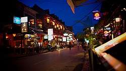 Pub Street | |
| Nickname(s): Temple Town [1] | |
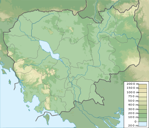 Siem Reap Location within Cambodia 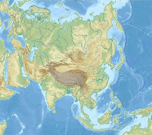 Siem Reap Location within Asia | |
| Coordinates: 13°21′44″N 103°51′35″E | |
| Country | |
| Province | Siem Reap Province |
| Municipality | Siem Reap Municipality |
| Settled | 802 |
| Official | 1907 |
| Government | |
| • Mayor | So Platong |
| Elevation | 18 m (59 ft) |
| Population (2018) | |
| • Total | 139,458 |
| • Rank | Ranked 5th |
| Time zone | UTC+7 (Cambodia) |
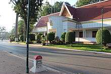
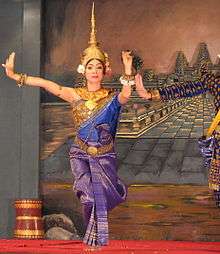
Siem Reap has colonial and Chinese-style architecture in the Old French Quarter and around the Old Market. In the city, there are museums, traditional Apsara dance performances, a Cambodian cultural village, souvenir and handicraft shops, silk farms, rice paddies in the countryside, fishing villages and a bird sanctuary near the Tonle Sap Lake, and a vibrant, cosmopolitan drinking and dining scene.
Siem Reap today—being a popular tourist destination—has many hotels, resorts, restaurants, and businesses closely related to tourism. This is much owed to its proximity to the Angkor temples, the most popular tourist attraction.
History

The name "Siem Reap" can be translated to mean 'defeat of Siam' (siem in Khmer), and is commonly taken as a reference to an incident in the centuries-old conflict between the Siamese and Khmer kingdoms, although this is probably apocryphal. According to oral tradition, King Ang Chan (1516–1566) had named the town "Siem Reap" after he repulsed an army sent to invade Cambodia by the Thai king Maha Chakkraphat in 1549.[2] However, scholars such as Michael Vickery consider this derivation to be simply a modern folk etymology, and maintain that while the names Siem Reap and Chenla. the old Chinese name for Cambodia, may perhaps be related, the actual origin of the name is unknown.[3]
The traditional tale claims that King Ang Chan of Cambodia tried to assert greater independence from Siam, which was then struggling internally. The Siamese king Chairacha had been poisoned by his concubine, Lady Sri Sudachan, who had committed adultery with a commoner, Worawongsathirat, while the king was away leading a campaign against the Kingdom of Chiang Mai. Sudachan then placed her lover on the throne. The Thai nobility lured them outside the city on a royal procession by barge to inspect a newly discovered white elephant. After killing the usurper, along with Sudachan and their new-born daughter, they invited Prince Thianracha to leave the monkhood and assume the throne as King Maha Chakkraphat (1548–1569). With the Thais distracted by their internal problems, King Ang Chan attacked. He seized the Siamese city of Prachinburi in 1549, sacking the city and making slaves of its inhabitants. Only then did he learn that the succession had been settled and that Maha Chakkraphat was the new ruler. Ang Chan immediately retreated to Cambodia, taking his captives with him. King Maha Chakkraphat was furious over the unprovoked attack, but Burma had also chosen to invade through Three Pagodas Pass. The Burmese army posed a much more serious threat, as it captured Kanchanaburi and Suphanburi. It then appeared before Ayutthaya itself.
The Thai army managed to defeat the Burmese, who quickly retreated through the pass. Maha Chakkraphat's thoughts then turned to Cambodia. Not only had Ang Chan attacked and looted Prachinburi, turning its people into slaves, but he also refused to give Maha Chakkraphat a white elephant he had requested, rejecting even this token of submission to Siam.[4] Maha Chakkraphat ordered Prince Ong, the governor of Sawankhalok, to lead an expedition to punish Ang Chan and recover the Thai captives. The rival armies met, and Ang Chan killed Prince Ong with a lucky musket shot from an elephant's back. The leaderless Thai army fled, and Ang Chan allegedly captured more than 10,000 Siamese soldiers. To celebrate his great victory, King Ang Chan supposedly named the battleground "Siem Reap", meaning 'the total defeat of Siam'.
In reality, surviving historic sources make this derivation appear unlikely, since they date the decline of Angkor to more than a century before this, when a military expedition from Ayutthaya captured and sacked Angkor Wat, which began a long period of vassal rule over Cambodia.[5] The 1431 capture coincided with the decline of Angkor, though the reasons behind its abandonment are not clear. They may have included environmental changes and failings of the Khmer infrastructure.[6]
From the 16th to the 19th centuries, infighting among the Khmer nobility led to periodic intervention and domination by both of Cambodia's more powerful neighbors, Vietnam and Siam. Siem Reap, along with Battambang (Phra Tabong) and Sisophon, major cities in northwest Cambodia, was under Siamese administration and the provinces were collectively known as Inner Cambodia from 1795 until 1907, when they were ceded to French Indochina. During the 18th century, under the rule of the Ayutthaya Kingdom, it was known as Nakhon Siam ('Siam's city').[7]
Re-discovery of Angkor

Siem Reap was little more than a village when French explorers such as Henri Mouhot "re-discovered" Angkor in the 19th century. However, European visitors had visited the temple ruins much earlier, including António da Madalena in 1586".[8] In 1901, the École française d'Extrême-Orient (EFEO) ('French School of the Far East') began a long association with Angkor by funding an expedition into Siam to the Bayon. The EFEO took responsibility for clearing and restoring the whole site. In the same year, the first Western tourists arrived in Angkor, a total of about 200 in just three months. Angkor had been "rescued" from the jungle and was assuming its place in the modern world.

With the acquisition of Angkor by the French in 1907 following a Franco-Siamese treaty, Siem Reap began to grow. The Grand Hotel d'Angkor opened in 1929 and the temples of Angkor became one of Asia's leading draws until the late-1960s, when civil war kept tourists away. In 1975, the population of Siem Reap, like all other Cambodian cities and towns, was driven into the countryside by the communist Khmer Rouge.
Siem Reap's recent history is colored by the horror of the brutal Khmer Rouge regime. Since Pol Pot's death in 1998, however, relative stability and a rejuvenated tourist industry have revived the city and province.
Siem Reap now serves as a small gateway town to the world heritage site of Angkor Wat. In recent years, the city has regularly ranked in the top ten for "Best Destination" lists produced by entities such as TripAdvisor, Wanderlust Magazine, and Travel+Leisure.[9]
The wat and the river
Siem Reap is a cluster of small villages along the Siem Reap River. These villages were originally developed around Buddhist pagodas (wats) which are almost evenly spaced along the river from Wat Preah En Kau Sei in the north to Wat Phnom Krom in the south, where the Siem Reap River meets the great Tonlé Sap Lake.
Town centre is concentrated around Sivutha Street and the Psar Chas area (Old Market area) where there are old colonial buildings, shopping and commercial districts. The Wat Bo area is now full of guesthouses and restaurants while the Psar Leu area is often crowded with jewelry and handicraft shops, selling such items as rubies and woodcarving. Other fast developing areas are the airport road and main road to Angkor where a number of large hotels and resorts can be found.
Economy
Tourism is a very important aspect of the economy of Siem Reap – it was estimated in 2010 that over 50% of jobs in the town were related to the tourism industry.[10] The city has seen a massive increase in tourist exchange in the couple of decades after the end of the Khmer Rouge era, and businesses centered on tourism have flourished due to the tourism boom. Visitor numbers were negligible in the mid-1990s, but by 2004, over half a million foreign visitors had arrived in Siem Reap Province that year, approximately 50% of all foreign tourists in Cambodia.[11] By 2012, tourist numbers had reached over two million.[12]
Attractions

Angkor Wat

Angkor Wat (Wat temple) is the central feature of the Angkor UNESCO World Heritage Site containing the magnificent remains of the Khmer civilization. Angkor Wat's rising series of five towers culminates in an impressive central tower that symbolizes mythical Mount Meru. Thousands of feet of wall space are covered with intricate carving depicting scenes from Hindu mythology. The most important are the Carved Bas reliefs of the Hindu narratives. They tell a story about gods fighting demons in order to reclaim order which can only be achieved by recovering the elixir of life known as amrita. The gods and demons must work together to release it and then battle to attain it.
Angkor Thom
.jpg)
Angkor Thom is an inner royal city built by Jayavarman VII, the Empire's famed 'Warrior King', at the end of the 12th century and is renowned for its temples, in particular the Bayon. Other notable sites are Baphuon, Phimeanakas, the Terrace of the Elephants, and the Terrace of the Leper King. The city can be accessed through five city gates, one at each cardinal point and the Victory Gate on the eastern wall.
Other temples
A number of significant temples are dotted around Angkor Wat and Angkor Thom within the Angkor Archaeological Park, including Ta Prohm, Preah Khan, Banteay Kdei, Phnom Bakheng, Ta Keo, Ta Som, East Mebon, Drukhsh, Pre Rup. and Neak Pean. These temples may be visited along the grand circuit or the small circuit routes.[13] Other sites are the Roluos group of temples located to the east of Siem Reap.
The Cambodia Landmine Museum and Relief Center
The Landmine Museum offers tourists and Cambodians the chance to see (safe) landmines up close, understand how they work, and what they can do to help rid Cambodia and the world of their continuing threat. It is approximately 25 km north of Siem Reap (30 minutes by tuk tuk), 7 km south of the Banteay Srey Temple complex in Angkor National Park.[14] Some two dozen at-risk Khmer children are educated and live, along with staff, at the Relief Center on the museum property.[15][16][17]
War Museum Cambodia
The War Museum Cambodia covers the last three decades of the 20th century when the Khmer Rouge was active in Cambodia. There is a vast array of vehicles, artillery, weaponry, landmines, and equipment on display. The museum is making use of guides who are war veterans who fought for the Cambodian army, the Khmer Rouge, or the Vietnamese army.
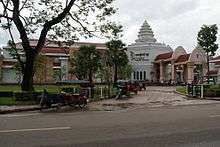
Angkor National Museum
Opened on 12 November 2007, the Angkor National Museum offers visitors a better understanding of the area's archaeological treasures. The Golden Era of the Khmer Kingdom is presented, including the use of state-of-the-art multimedia technology. The museum covers Khmer history, civilization, and cultural heritage in eight galleries.[18]
Markets
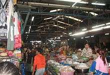
The Old Market or Psah Chas is between Pub Street and the Siem Reap River, and offers a mixture of souvenirs for tourists and a variety of food produce and other items meant for the locals.[19]
Other markets in Siem Reap include the Angkor Night Market which is off Sivutha Street,[20] Phsar Kandal (the Central Market) on Sivutha Street which mainly caters to tourists, and Phsar Leu (the Upper Market) which is further away along National Road 6 but is the biggest market of Siem Reap used by the locals.[21] The Made in Cambodia Market (initially called "Well Made in Cambodia")[22] is a night market for tourists in Siem Reap where all the products sold are made in Cambodia. The market hosts daily shows and other events in King's Road.[23]


Artisans Angkor
Artisans Angkor is a semi-public company founded in 1992 which aims to revive traditional Khmer craftsmanship and provide employment for rural artisans. It is also associated with a silk farm where visitors may learn about sericulture and weaving.[24] It also participates in the restoration of historical Angkor sites by repairing and replacing damaged sculptures.[25]
Cambodian Cultural Village
Opened on 24 September 2003, the Cambodian Cultural Village assembles all the miniatures of famous historical buildings and structures of Cambodia. There are 11 unique villages, which represent different culture heritages, local customs, and characteristics of 21 multi races.
Notable sites near Siem Reap
_(6824988525).jpg)
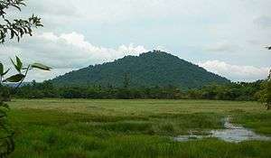
Phnom Kulen
Phnom Kulen National Park is about 48 km from Siem Reap and contains a number of attractions such as its two waterfalls and the Kbal Spean's 'river of 1000 lingas'. It is also home to Preah Ang Thom, an active, 16th century pagoda that is home to the largest reclining Buddha in Cambodia.[26]

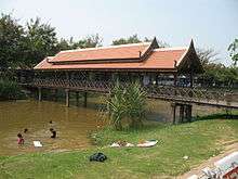
Floating villages
There are four floating villages around Siem Reap: Kompong Khleang, Kompong Phluk, Chong Kneas, and Meychrey, home to a bird sanctuary. Kompong Khleang is considered the largest and most authentic and Chong Kneas the least authentic but most visited due to its proximity to the city.[27]
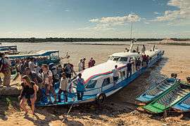
Tonlé Sap
Tonlé Sap, Khmer for 'vast body of fresh water' and more commonly translated as 'great lake', is a combined lake and river system of major importance to Cambodia. It is in the heart of Cambodia and is home to many floating villages. Tonle Sap is 30 minutes south of downtown Siem Reap at the port of Chong Kneas. The lake and its villages have many unique features and attractions, making Tonle Sap tours popular with tourists. The area around the Tonle Sap including the province of Siem Reap is part of the greater Tonle Sap Biosphere Reserve.
Phnom Dei
Phnom Dei is a hill near Siem Reap.
Banteay Srei
Banteay Srei is a 10th-century temple about 30 km northeast of Siem Reap. It is notable for its fine intricate decorative carvings on rose pink sandstone.[28]
Local specialty
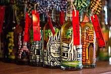
Rice wine
Traditionally rice wine may be made by the Cambodian households or villages for their own consumption. Some are also produced commercially or inspired by this tradition, an example is the Sombai Infused Cambodian Liqueur (Sombai) produced in Siem Reap.[29] This beverage takes inspiration from the Sraa Tram (or soaked wine) that Cambodians drink traditionally and the infused rums from the islands.[30][31] The particularity of the bottles of Sombai is that they are hand-painted making it attractive to tourists visiting Cambodia.[32][33][34] The workshop and its tasting parlour installed in a traditional Khmer wooden house, has become a tourist attraction in town.[35][36][37]
Climate
According to the Köppen climate classification, Siem Reap features a tropical wet and dry climate. The city is generally hot throughout the course of the year, with average high temperatures never falling below 30 C in any month. Siem Reap has a relatively lengthy wet season which starts in May and ends in October. The dry season covers the remaining six months. The city averages approximately 1406 mm of rainfall per year.
| Climate data for Siem Reap, Cambodia (averages: 1997–2010, extremes: 1906–2010) | |||||||||||||
|---|---|---|---|---|---|---|---|---|---|---|---|---|---|
| Month | Jan | Feb | Mar | Apr | May | Jun | Jul | Aug | Sep | Oct | Nov | Dec | Year |
| Record high °C (°F) | 35.0 (95.0) |
36.7 (98.1) |
38.9 (102.0) |
39.4 (102.9) |
40.6 (105.1) |
38.9 (102.0) |
35.6 (96.1) |
35.0 (95.0) |
34.4 (93.9) |
33.9 (93.0) |
34.4 (93.9) |
34.4 (93.9) |
40.6 (105.1) |
| Average high °C (°F) | 31.7 (89.1) |
33.5 (92.3) |
34.9 (94.8) |
35.8 (96.4) |
34.8 (94.6) |
33.6 (92.5) |
32.9 (91.2) |
32.4 (90.3) |
31.7 (89.1) |
31.5 (88.7) |
31.2 (88.2) |
30.6 (87.1) |
32.9 (91.2) |
| Daily mean °C (°F) | 26.0 (78.8) |
27.8 (82.0) |
29.5 (85.1) |
30.5 (86.9) |
29.9 (85.8) |
29.2 (84.6) |
28.9 (84.0) |
28.8 (83.8) |
28.1 (82.6) |
28.0 (82.4) |
26.9 (80.4) |
25.6 (78.1) |
28.3 (82.9) |
| Average low °C (°F) | 20.4 (68.7) |
22.4 (72.3) |
24.1 (75.4) |
25.4 (77.7) |
25.4 (77.7) |
25.1 (77.2) |
24.9 (76.8) |
25.1 (77.2) |
24.7 (76.5) |
24.5 (76.1) |
22.6 (72.7) |
20.7 (69.3) |
23.8 (74.8) |
| Record low °C (°F) | 9.4 (48.9) |
12.8 (55.0) |
15.0 (59.0) |
17.8 (64.0) |
18.9 (66.0) |
17.8 (64.0) |
18.9 (66.0) |
18.9 (66.0) |
20.0 (68.0) |
17.2 (63.0) |
12.2 (54.0) |
10.0 (50.0) |
9.4 (48.9) |
| Average rainfall mm (inches) | 3.7 (0.15) |
4.7 (0.19) |
29.0 (1.14) |
57.3 (2.26) |
149.7 (5.89) |
214.1 (8.43) |
192.6 (7.58) |
208.9 (8.22) |
287.7 (11.33) |
199.6 (7.86) |
51.3 (2.02) |
7.3 (0.29) |
1,405.9 (55.36) |
| Average rainy days (≥ 0.1 mm) | 1.5 | 0.7 | 3.2 | 7.6 | 17.0 | 18.0 | 17.6 | 17.6 | 17.4 | 15.4 | 6.4 | 2.0 | 124.4 |
| Average relative humidity (%) | 59 | 59 | 58 | 59 | 66 | 70 | 71 | 73 | 75 | 75 | 68 | 64 | 66 |
| Source: Deutscher Wetterdienst[38] | |||||||||||||
Transportation
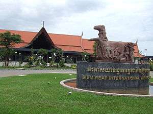
The town is 7 kilometres (4.3 mi) from Siem Reap-Angkor International Airport (IATA code REP) and is accessible by direct flights from many Asian cities, and by land from Phnom Penh and the Thai border. It is also accessible by boat (via Tonle Sap lake). There are also buses from Phnom Penh and Battambang, with buses between Phnom Penh and Siem Reap taking about 6 hours.[39] A new airport is planned 60 kilometres (37 mi) from Siem Reap.[40]
It is possible to get from Bangkok to Siem Reap via Poipet. The road from Poipet to Siem Reap is newly paved and sealed as of 2013. If travelers take a taxi from Bangkok to Poipet and from Poipet to Siem Reap, it is possible to complete the whole journey in 6–10 hours, depending on border-crossing times. This journey is also possible by bus and minibus. Tickets can be bought online via the official Nattakan website. Getting to Siem Reap from Bangkok is also possible by train via the Aranyaprathet station to the border with Cambodia and later via shared mini-buses or taxis to Siem Reap.[41]
Sister cities


- Jiangxi Province, China
- Orland Park, Illinois

References
- Glasser, Miranda (14 September 2012). "Temple Town, Cambodia's new ladyboy capital". Phnom Penh Post. Retrieved 14 December 2015.
- Joachim Schliesinger (2012). Elephants in Thailand Vol 3: White Elephants in Thailand and Neighboring Countries. White Lotus. p. 32. ISBN 978-9744801890.
- Zhou Daguan (2007). A Record of Cambodia. Translated by Peter Harris. University of Washington Press. ISBN 978-9749511244.
- Paul Spencer Sochaczewski (29 January 2009). The Sultan and the Mermaid Queen: Surprising Asian People, Places and Things that Go Bump in the Night. Editions Didier Millet. pp. 100–. ISBN 978-981-4217-74-3.
- John Stewart Bowman (13 August 2013). Columbia Chronologies of Asian History and Culture. Columbia University Press. pp. 511–. ISBN 978-0-231-50004-3.
- Stone, R. (2006). "The End of Angkor". Science. 311 (5766): 1364–1368. doi:10.1126/science.311.5766.1364. ISSN 0036-8075. PMID 16527940.
- Gerald W. Fry; Gayla S. Nieminen; Harold E. Smith (8 August 2013). Historical Dictionary of Thailand. Scarecrow Press. pp. 362–. ISBN 978-0-8108-7525-8.
- Higham, The Civilization of Angkor pp. 1–2.
- "The "Top 25" best destinations in the world". Wanderlust. 2015.
- Robin Biddulph (January 2015). "Limits to mass tourism's effects in rural peripheries". Annals of Tourism Research. 50: 98–112. doi:10.1016/j.annals.2014.11.011.
- "Executive Summary from Jan–Dec 2005". Tourism of Cambodia. Statistics & Tourism Information Department, Ministry of Tourism of Cambodia. Archived from the original on 13 April 2008. Retrieved 25 April 2008.
- "Tourism Annual Report 2012" (PDF). Ministry of Tourism. Archived from the original (PDF) on 27 October 2016. Retrieved 20 November 2015.
- "Angkor Temple Guide". Canby Publications.
- "Where are we located?". The Cambodia Landmine Museum and School. Retrieved 1 November 2018.
- "The Cambodian Landmine Museum and School". The Cambodia Landmine Museum and School. Retrieved 1 November 2018.
- Al Brenner (28 October 2013). "landmine museum". Retrieved 1 November 2018 – via YouTube.
- Al Brenner (30 October 2013). "Poem of the landmine museum". Retrieved 1 November 2018 – via YouTube.
- "Angkor National Museum website". Angkornationalmuseum.com. Archived from the original on 25 September 2011. Retrieved 31 January 2011.
- "Psar Chaa". Lonely Planet.
- "Angkor Night Market". Lonely Planet.
- "Local markets in Siem Reap". Siemreap.net.
- "Shinta Mani "Well Made in Cambodia" Market". Siemreap.net.
- "Laura Mam and Krom performing in town". The Phnom Penh Post.
- Walter E. Little (2011). Textile Economies: Power and Value from the Local to the Transnational. AltaMira Press. pp. 207–208. ISBN 978-0759120617.
- "Restoration of Angkor site". Artisans Angkor. Archived from the original on 8 July 2015. Retrieved 23 November 2015.
- "7 Reasons Phnom Kulen is a Must See in Siem Reap – Kulen Revealed". Kulen Revealed. 7 July 2018. Retrieved 23 August 2018.
- "Siem Reap floating villages: What to expect and why we choose to go to Kompong Khleang". Triple Adventure Cambodia.
- Beverley Palmer. The Rough Guide to Cambodia. Rough Guides. p. 196. ISBN 978-1848368897.
- Nicky Sullivan "Fruit-flavoured infused rice wines make a splash". The Phnom Penh Post, 7 September 2012,
- "Associated Press: Rice wine spirit is rebranded as a tourist tipple". Retrieved 3 August 2015.
- Lara Dunston "Cambodian rice wine revival". Australian Gourmet Traveller, 11 July 2014
- Lara Dunston "Taste Siem Reap's Own Brand of Infused Rice Spirit". Afar
- Nick Ray "Sombai". Lonely Planet Online
- Peter Olszewski "Cambodian Fusion". Archived from the original on 9 January 2016. Management Insider
- Robyn Eckhardt "36 Hours in Siem Reap". The New York Times, 22 July 2015
- Dana Ter"Searching for serenity in Siem Reap"., Taipei Times, 19 August 2015
- Miranda Glasser "Taste Sombai rice wine purveyors open new showroom". The Phnom Penh Post, 1 August 2014
- "Klimatafel von Siemreap-Angkor / Kambodscha" (PDF). Baseline climate means (1961–1990) from stations all over the world (in German). Deutscher Wetterdienst. Retrieved 23 January 2016.
- "Phnom Penh to Siem Reap". GeckoRoutes. 24 September 201. Retrieved 4 October 2019.
- "Cambodia eyes new airport for Siem Reap". Retrieved 22 September 2010.
- "How to get from Siem Reap to Bangkok?". tripsget.com. Archived from the original on 27 May 2016. Retrieved 31 May 2016.
- "?". Myanmar.gov.mm. Archived from the original on 22 August 2007.
- "Local Government International Exchange: Sister city information Database". Council of Local Authorities for International Relations (CLAIR). Archived from the original on 24 December 2015. Retrieved 21 November 2015.
External links
| Wikimedia Commons has media related to Siem Reap. |
- Official Siem Reap website

- 257838557 Siem Reap on OpenStreetMap
| |||||||||||||||||||||||

| Authority control |
|
|---|