Kampong Cham (city)
Kampong Cham (Khmer: ក្រុងកំពង់ចាម) is the capital city of Kampong Cham Province in eastern Cambodia. It is the 12th largest city in Cambodia with a population of 41,468 people (2010)and is located on the Mekong River. Kampong Cham is 124 kilometers northeast from Phnom Penh and can be reached by either boat or by asphalt road. It takes about 2.5 hours by vehicle or 2.5 hours by boat from Phnom Penh to the city of Kampong Cham. Its geographic location is 12.00°N, 105.46°E.
Kampong Cham ក្រុងកំពង់ចាម | |
|---|---|
City | |
 | |
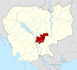
 Kampong Cham Location of Kampong Cham, Cambodia | |
| Coordinates: 11°59′13.3″N 105°27′43.3″E | |
| Country | |
| Province | Kampong Cham |
| District | Kampong Cham District |
| Government | |
| • Type | City municipality |
| Elevation | 20 m (70 ft) |
| Population (2010)[1] | |
| • Total | 41,468 |
| • Rank | Ranked 6th |
| Time zone | UTC+7 (Cambodia) |
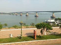
The city is connected to the district of Tbong khmum by the Kizuna bridge, the first in Cambodia to span the Mekong.
Administrative division
The city is subdivided into four sangkats and 32 villages.
Demographics
Politic
The indirect election of city council in 2014 give the presidentship to CPP which has won 11 out of the 15 seats in the city council. The rest were won by CNRP.
Economy
Education
General Education
Higher Education
Culture
Cityscape and architecture
Sport
Kampong Cham has a great outdoor Olympic size 50 meter swimming pool with 5 and 10 meter diving boards. As of January 2020 the entry cost was $2 USD. There is a swim club, coached by Japanese volunteers.
Transport
Water supply
Climate
his city has a tropical climate. When compared with winter, the summers have much more rainfall. This location is classified as Aw by Köppen and Geiger. The average annual temperature in Kampong Cham is 27.7 °C. Precipitation here averages 1722 mm.
| Climate data for Kampong Cham, Cambodia | |||||||||||||
|---|---|---|---|---|---|---|---|---|---|---|---|---|---|
| Month | Jan | Feb | Mar | Apr | May | Jun | Jul | Aug | Sep | Oct | Nov | Dec | Year |
| Record high °C (°F) | 35 (95) |
37 (99) |
38 (100) |
39 (102) |
37 (99) |
36 (97) |
37 (99) |
35 (95) |
34 (93) |
34 (93) |
33 (91) |
35 (95) |
39 (102) |
| Average high °C (°F) | 31.5 (88.7) |
32.9 (91.2) |
34.1 (93.4) |
34.7 (94.5) |
33.5 (92.3) |
32.2 (90.0) |
31.4 (88.5) |
31.5 (88.7) |
31.1 (88.0) |
30.8 (87.4) |
30.8 (87.4) |
30.7 (87.3) |
32.1 (89.8) |
| Daily mean °C (°F) | 26.1 (79.0) |
27.4 (81.3) |
29.5 (85.1) |
29.7 (85.5) |
29.1 (84.4) |
28.1 (82.6) |
27.6 (81.7) |
27.7 (81.9) |
27.4 (81.3) |
27.1 (80.8) |
26.7 (80.1) |
26.1 (79.0) |
27.7 (81.9) |
| Average low °C (°F) | 20.8 (69.4) |
21.9 (71.4) |
25.0 (77.0) |
24.8 (76.6) |
24.7 (76.5) |
24.1 (75.4) |
23.9 (75.0) |
24.0 (75.2) |
23.8 (74.8) |
23.5 (74.3) |
22.7 (72.9) |
21.5 (70.7) |
23.4 (74.1) |
| Record low °C (°F) | 10 (50) |
10 (50) |
18 (64) |
20 (68) |
20 (68) |
21 (70) |
20 (68) |
21 (70) |
21 (70) |
18 (64) |
16 (61) |
11 (52) |
10 (50) |
| Average precipitation mm (inches) | 4 (0.2) |
5 (0.2) |
33 (1.3) |
86 (3.4) |
242 (9.5) |
228 (9.0) |
224 (8.8) |
271 (10.7) |
263 (10.4) |
247 (9.7) |
106 (4.2) |
12 (0.5) |
1,721 (67.9) |
| Average relative humidity (%) | 67 | 66 | 66 | 68 | 76 | 79 | 79 | 81 | 83 | 81 | 76 | 72 | 75 |
| Source 1: Climate-Data.org (temp & precip)[2] | |||||||||||||
| Source 2: Weatherbase (humidity)[3] | |||||||||||||
Place to see
See also
- Cham people
- Cham language
References
- "2008 Census". Archived from the original on 2013-01-11.
- "Climate: Kampong Cham". Climate-Data.org. Retrieved 19 May 2016.
- "KAMPONG CHAM, CAMBODIA". Weatherbase. Retrieved 19 May 2016.
External links

| ||||||||||||||||||||||||||||||||