Shilat
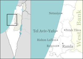
Shilat (Hebrew: שִׁילָּת) is an Israeli moshav located around a kilometre north of Modi'in in the Latrun Salient of the Green Line. It falls under the jurisdiction of Hevel Modi'in Regional Council. In 2018 it had a population of 757.[1]
Shilat שִׁילָּת | |
|---|---|
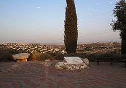 Memorial to 45 fallen soldiers | |
 Shilat | |
| Coordinates: 31°55′13.44″N 35°1′7.32″E | |
| Country | Israel |
| District | Central |
| Council | Hevel Modi'in |
| Affiliation | HaOved HaTzioni |
| Founded | July 1977 |
| Population (2018)[1] | 757 |
| Website | www.shilat.co.il |
The Shilat Junction, at the intersection of Route 443 and Route 446, is the main northern entrance to Modi'in and the site of an industrial park which houses many commercial establishments as well as light industry.
History
The moshav was established in July 1977 by 25 families on land that had belonged the Palestinian village of Shilta, which was depopulated in 1948.[2] After the Six-Day War in 1967, Israel confiscated 781 dunams of land from the Palestinian village of Saffa for the construction of Shilat.[3]
References
- "Population in the Localities 2018" (XLS). Israel Central Bureau of Statistics. 25 August 2019. Retrieved 26 August 2019.
- Khalidi, Walid (1992). All that Remains: The Palestinian Villages Occupied and Depopulated by Israel in 1948. Washington DC: Institute for Palestine Studies. p. 414. ISBN 0-88728-224-5.
- Saffa village profile, ARIJ, p. 17
This article is issued from Wikipedia. The text is licensed under Creative Commons - Attribution - Sharealike. Additional terms may apply for the media files.