Segni
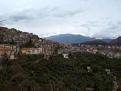
Segni (Latin: Signia, Ancient Greek: Σιγνία) is an Italian town and comune located in Lazio. The city is situated on a hilltop in the Lepini Mountains, and overlooks the valley of the Sacco River.
Segni | |
|---|---|
| Città di Segni | |
 | |
 Coat of arms | |
Location of Segni 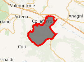
| |
 Segni Location of Segni in Italy 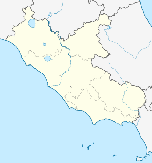 Segni Segni (Lazio) | |
| Coordinates: 41°41′N 13°01′E | |
| Country | Italy |
| Region | Lazio |
| Metropolitan city | Rome (RM) |
| Government | |
| • Mayor | Stefano Corsi |
| Area | |
| • Total | 61 km2 (24 sq mi) |
| Elevation | 668 m (2,192 ft) |
| Population (31 May 2012)[2] | |
| • Total | 9,375 |
| • Density | 150/km2 (400/sq mi) |
| Demonym(s) | Segnini |
| Time zone | UTC+1 (CET) |
| • Summer (DST) | UTC+2 (CEST) |
| Postal code | 00037 |
| Dialing code | 06 |
| Patron saint | San Bruno |
| Saint day | July 18 |
| Website | Official website |
History
Early history
According to ancient Roman sources, Lucius Tarquinius Superbus, the seventh king of Rome, established a Roman colony at the town, then known as Signia.[3] Additional colonists were reportedly sent there in 495 BC.[4][5]
The ancient architectural remains at the site date mostly from the Republican period. These include a circuit of fortification walls built using polygonal masonry. The walls incorporated a system of gates, including the Porta Saracena which is covered by a large monolithic architrave. Atop the ancient acropolis of Segni sits the podium of the temple of Juno Moneta, which now supports a Medieval church of Saint Peter (tenth century).
Later history
Segni was a refuge for various popes with Pope Eugene III erecting a palace in the middle of the twelfth century. The Counts of Marsi, hereditary enemies of the Orsini, obtained Segni in the twelfth century. The family called de' Conti produced several popes (Innocent III, Gregory IX and Alexander IV) and many cardinals. In 1558 Segni was sacked by the forces of the Duke of Alba in the war against Pope Paul IV; immense booty was captured, as the inhabitants of the other towns of the Campagna had fled thither. Politician Giulio Andreotti was born in Segni in 1919.
Main sights
- Co-cathedral of Santa Maria Assunta, built in the early 17th century on the former temple of St. Bruno. The bell tower is from the 11th century. The interior has a painting by Francesco Cozza.
- The polygonal masonry fortification walls of the settlement are well preserved.[6]

- The ancient acropolis of Segni is marked by the former site of the temple of Juno Moneta. The acropolis has recently been the site of renewed fieldwork undertaken by the British School at Rome.[7][8]

Twin towns

References
- "Superficie di Comuni Province e Regioni italiane al 9 ottobre 2011". Istat. Retrieved 16 March 2019.
- Population data from Istat
- Livy, Ab urbe condita, 1.56; Dionysius of Halicarnassus 4.63
- Livy, Ab urbe condita, 2:21
- Quilici, L., S. Quilici Gigli, DARMC, R. Talbert, S. Gillies, T. Elliott, J. Becker. "Places: 423072 (Signia)". Pleiades. Retrieved October 20, 2014.CS1 maint: multiple names: authors list (link)
- G. M. De Rossi. 1982. Segni. Rome: De Luca.
- Francesco Maria Cifarelli (2003). Il tempio di Giunone Moneta sull'acropoli di Segni: storia, topografia e decorazione architettonica. L'ERMA di BRETSCHNEIDER. ISBN 978-88-8265-239-5.
- Segni Project http://www.bsr.ac.uk/research/archaeology/ongoing-projects/segni-project
![]()
| Authority control |
|
|---|