Sattahip District
Sattahip (Thai: สัตหีบ, pronounced [sàt.tā.hìːp]) is a district (amphoe) in Chonburi Province, Thailand. It is at the southern tip of the province southeast of Bangkok. In 2014, the district had a population of 157,000 in an area of 348,122 km2.
Sattahip สัตหีบ | |
|---|---|
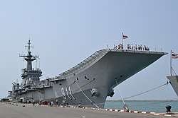 HTMS Chakri Naruebet at Sattahip Naval Base | |
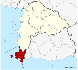 District location in Chonburi Province | |
| Coordinates: 12°39′47″N 100°54′20″E | |
| Country | Thailand |
| Province | Chonburi |
| Seat | Sattahip |
| Area | |
| • Total | 348.122 km2 (134.411 sq mi) |
| Population (2015) | |
| • Total | 159,395 |
| • Density | 457.87/km2 (1,185.9/sq mi) |
| Time zone | UTC+7 (ICT) |
| Postal code | 20180 |
| Geocode | 2009 |
Geography
Neighboring districts are Bang Lamung to the north, and Ban Chang of Rayong Province to the east. To the south and the west is the Gulf of Thailand.
Islands
Several islands are in Sattahip District, the largest of which is Ko Khram Yai. Many of the islands are in Sattahip Bay (อ่าวสัตหีบ).[1]
| Name | Thai Name | Location | Coordinates |
|---|---|---|---|
| Ko Khram | เกาะคราม | Ko Khram group | 12.70°N 100.79°E |
| Ko Klet Kaeo | เกาะเกล็ดแก้ว | Ko Khram group | 12.761°N 100.845°E |
| Ko Khram Noi | เกาะครามน้อย | Ko Khram group | 12.727°N 100.798°E |
| Ko I Ra | เกาะอีร้า | Ko Khram group | 12.676°N 100.823°E |
| Ko Tao Mo | เกาะเตาหม้อ | Sattahip Bay group | 12°38′17″N 100°52′13″E |
| Ko Phra | เกาะพระ | Sattahip Bay group | 12°38′37″N 100°53′17″E |
| Ko Phra Noi | เกาะพระน้อย | Sattahip Bay group | 12°38′46″N 100°53′15″E |
| Ko I Lao | เกาะอีเลา | Sattahip Bay group | 12°36′42″N 100°52′32″E |
| Ko Yo | เกาะยอ | Sattahip Bay group | 12°36′59″N 100°52′52″E |
| Ko Mu | เกาะหมู | Sattahip Bay group | 12°37′26″N 100°54′3″E |
| Ko Maeo | เกาะแมว | Sattahip Bay group | 12°36′40″N 100°53′21″E |
| Ko Nang Ram | เกาะนางรำ | Sattahip Bay group | 12°36′59″N 100°56′3″E |
| Ko Chorakhe | เกาะจระเข้ | Sattahip Bay group | 12°36′12″N 100°55′0″E |
| Ko Samae San | เกาะแสมสาร | Ko Samae San group | 12.573°N 100.95°E |
| Ko Kham | เกาะขาม | Ko Samae San group | 12.573°N 100.934°E |
| Ko Raet | เกาะแรด | Ko Samae San group | 12.585°N 100.964°E |
| Ko Chang Kluea | Ko Samae San group | 12.550°N 100.971°E | |
| Ko Chuang | เกาะช่วง | Ko Samae San group | 12.520°N 100.96°E |
| Ko Chan | เกาะจาน | Ko Samae San group | 12.521°N 100.970°E |
| Ko Rong Nang | เกาะโรงหนัง | Ko Samae San group | 12.53437°N 100.95870°E |
| Ko Rong Khon | เกาะโรงโขน | Ko Samae San group | 12.53169°N 100.95972°E |
History
The recorded history of Sattahip begins with a woman named Jang, who owned much land in Sattahip District. Admiral Prince Abhakara Kiartivongse, a son of King Rama V, was sent to create a naval base at Sattahip. He thought it was perfect owing to the many small islands that protected it from wind and waves. He ask Jang for land on the seacoast, and she donated the area that the prince needed.
In Thai, satta (Thai: สัต) means 'seven', while hip (Thai: หีบ) means 'box' or 'barrier'. Thus Sattahip means the 'seven barriers', which are the islands that protect the coast of the district. These islands are Ko Phra, Ko Yo, Ko Mu, Ko Tao Mo, Ko Nen, Ko San Chalam and Ko Bo.
The minor district (king amphoe) Sattahip was created on 1 April 1937 by separating the sub-districts Sattahip and Na Chom Thien from Bang Lamung District.[2] It was upgraded to a full district in 1953.[3]
Climate
| Climate data for Sattahip (1981–2010) | |||||||||||||
|---|---|---|---|---|---|---|---|---|---|---|---|---|---|
| Month | Jan | Feb | Mar | Apr | May | Jun | Jul | Aug | Sep | Oct | Nov | Dec | Year |
| Record high °C (°F) | 36.5 (97.7) |
36.5 (97.7) |
37.8 (100.0) |
37.2 (99.0) |
38.7 (101.7) |
37.5 (99.5) |
37.0 (98.6) |
37.2 (99.0) |
36.2 (97.2) |
36.2 (97.2) |
36.5 (97.7) |
36.4 (97.5) |
38.7 (101.7) |
| Average high °C (°F) | 32.0 (89.6) |
32.2 (90.0) |
32.7 (90.9) |
33.7 (92.7) |
33.5 (92.3) |
33.2 (91.8) |
33.8 (92.8) |
32.7 (90.9) |
32.4 (90.3) |
32.3 (90.1) |
32.6 (90.7) |
32.3 (90.1) |
32.7 (90.9) |
| Daily mean °C (°F) | 26.2 (79.2) |
27.5 (81.5) |
28.6 (83.5) |
29.8 (85.6) |
29.6 (85.3) |
29.4 (84.9) |
28.9 (84.0) |
28.8 (83.8) |
28.1 (82.6) |
27.3 (81.1) |
26.9 (80.4) |
26.0 (78.8) |
28.1 (82.6) |
| Average low °C (°F) | 21.0 (69.8) |
23.3 (73.9) |
25.2 (77.4) |
26.3 (79.3) |
26.1 (79.0) |
26.0 (78.8) |
25.6 (78.1) |
25.6 (78.1) |
24.8 (76.6) |
23.8 (74.8) |
22.4 (72.3) |
20.6 (69.1) |
24.2 (75.6) |
| Record low °C (°F) | 13.2 (55.8) |
16.0 (60.8) |
16.5 (61.7) |
10.0 (50.0) |
21.7 (71.1) |
21.7 (71.1) |
19.1 (66.4) |
19.8 (67.6) |
21.5 (70.7) |
18.0 (64.4) |
15.9 (60.6) |
11.2 (52.2) |
10.0 (50.0) |
| Average rainfall mm (inches) | 25.6 (1.01) |
19.4 (0.76) |
58.8 (2.31) |
78.9 (3.11) |
171.9 (6.77) |
130.1 (5.12) |
107.5 (4.23) |
109.0 (4.29) |
219.0 (8.62) |
259.8 (10.23) |
76.1 (3.00) |
10.5 (0.41) |
1,266.6 (49.87) |
| Average rainy days | 2.6 | 2.6 | 4.6 | 6.6 | 12.4 | 12.9 | 12.5 | 13.6 | 17.1 | 17.4 | 6.4 | 1.5 | 110.2 |
| Average relative humidity (%) | 72 | 75 | 76 | 76 | 77 | 77 | 77 | 78 | 81 | 82 | 74 | 69 | 76 |
| Mean monthly sunshine hours | 195.3 | 180.8 | 186.0 | 186.0 | 117.8 | 114.0 | 117.8 | 58.9 | 108.0 | 108.5 | 171.0 | 192.2 | 1,736.3 |
| Mean daily sunshine hours | 6.3 | 6.4 | 6.0 | 6.2 | 3.8 | 3.8 | 3.8 | 1.9 | 3.6 | 3.5 | 5.7 | 6.2 | 4.8 |
| Source 1: Thai Meteorological Department[4] | |||||||||||||
| Source 2: Office of Water Management and Hydrology, Royal Irrigation Department (sun and humidity)[5] | |||||||||||||
Administration
The district is divided into five sub-districts (tambons), which are further subdivided into 41 villages (mubans). There are three sub-district municipalities (thesaban tambons): Sattahip, Na Chom Thian, and Bang Sare. Sattahip covers parts of tambons Sattahip and Phlu Ta Luang. Na Chom Thian and Bang Sare each parts of the same-named tambon. There are a further five tambon administrative organizations (TAO).
| No. | Name | Thai | Villages | Pop. |
|---|---|---|---|---|
| 1. | Sattahip | สัตหีบ | 9 | 72,715 |
| 2. | Na Chom Thian | นาจอมเทียน | 9 | 11,555 |
| 3. | Phlu Ta Luang | พลูตาหลวง | 8 | 30,355 |
| 4. | Bang Sare | บางเสร่ | 11 | 16,942 |
| 5. | Samaesan | แสมสาร | 4 | 6,032 |
References
- Mapcarta
- ประกาศกระทรวงมหาดไทย เรื่อง ตั้งกิ่งอำเภอสัตหีบ (PDF). Royal Gazette (in Thai). 53 (0 ง): 3926–3927. 1937-02-28.
- พระราชกฤษฎีกาจัดตั้งอำเภอจักราช อำเภอสัตตหีบ อำเภอศรีสงคราม อำเภอชะอวด อำเภอหนองแซง อำเภอภาชี อำเภอเขาไชยสน อำเภอชุมพลบุรี อำเภอวาริชภูมิ อำเภอสบปราบ และอำเภอสุไหงโกลก พ.ศ. ๒๔๙๖ (PDF). Royal Gazette (in Thai). 70 (17 ก): 368. 1953-03-10.
- "Climatological Data for the Period 1981–2010". Thai Meteorological Department. p. 20. Retrieved 6 August 2016.
- "ปริมาณการใช้น้ำของพืชอ้างอิงโดยวิธีของ Penman Monteith (Reference Crop Evapotranspiration by Penman Monteith)" (PDF) (in Thai). Office of Water Management and Hydrology, Royal Irrigation Department. p. 96. Retrieved 6 August 2016.
| Wikimedia Commons has media related to Sattahip District. |
External links

- amphoe.com (in Thai)