Santo Antônio de Pádua
Santo Antônio de Pádua (Portuguese pronunciation: [ˈsɐ̃tw‿ɐ̃ˈtõɲu dʒi ˈpadwɐ], Saint Anthony of Padua) is a municipality located in the northeastern part of the Brazilian state of Rio de Janeiro. Its population was 40,589 (2010) and its area is 612 km².[1]
Santo Antônio de Pádua | |
|---|---|
Municipality | |
| Município de Santo Antônio de Pádua | |
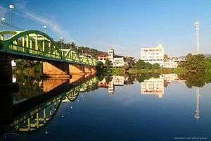 Raul Veiga Bridge | |
 Flag  Seal | |
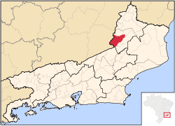 Location of Santo Antônio de Pádua in the state of Rio de Janeiro | |
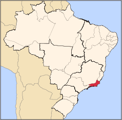
 Santo Antônio de Pádua Location of Santo Antônio de Pádua in Brazil | |
| Coordinates: 21°32′20″S 42°10′48″W | |
| Country | |
| Region | Southeast |
| State | |
| Government | |
| • Prefeito | Josias de Oliveira (PSB) |
| Area | |
| • Total | 611.981 km2 (236.287 sq mi) |
| Elevation | 86 m (282 ft) |
| Population (2010) | |
| • Total | 40,589 |
| Time zone | UTC-3 (UTC-3) |
| Website | |
Districts
- Santo Antônio de Pádua (seat)
- Baltazar
- Campelo
- Ibitiguaçu
- Marangatu
- Monte Alegre
- Paraoquena
- Santa Cruz
Neighboring municipalities
Coat of arms
The coat of arms of Santo Antônio de Pádua features eight stars representing eight of its districts on a navy blue field of the shield with a tree on the right and a fountain in the middle. The municipality's name is centered in the shield and it runs diagonally from bottom left to top right. The shield is bordered with four orange rectangles on each side. The crown is on the top of the coat of arms.
External links
- (in Portuguese) Santo Antônio de Pádua City Hall
References
- IBGE -
Capital: Rio de Janeiro | |||||||||||
| Mesoregion Baixadas |
|  | |||||||||
| Mesoregion Centro Fluminense |
| ||||||||||
| Mesoregion Metropolitana do Rio de Janeiro |
| ||||||||||
| Mesoregion Noroeste Fluminense |
| ||||||||||
| Mesoregion Norte Fluminense |
| ||||||||||
| Mesoregion Sul Fluminense |
| ||||||||||
This article is issued from Wikipedia. The text is licensed under Creative Commons - Attribution - Sharealike. Additional terms may apply for the media files.