Bom Jesus do Itabapoana
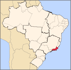
Bom Jesus do Itabapoana (Portuguese pronunciation: [ˈbõ(w) ʒeˈzu(j)z dw‿itɐbapuˈɐ̃nɐ]) is a municipality in the Brazilian state of Rio de Janeiro. It had a population of 35,411 as of 2010, and has an area of 598,8 km2. It was founded in 1939, after being separated from the municipality of Itaperuna.[1]
Bom Jesus do Itabapoana | |
|---|---|
Municipality | |
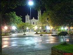 Town's Mother Parish | |
 Flag  Seal | |
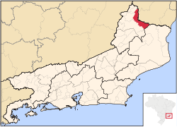 Location of Bom Jesus do Itabapoana | |
| Country | |
| Region | Southeast |
| State | Rio de Janeiro |
| Mesoregion | Noroeste Fluminense |
| Microregion | Itaperuana |
| Founded | 1939 |
| Government | |
| • Mayor | Maria das Graças Ferreira Motta (PMDB) |
| Area | |
| • Total | 598.401 km2 (231.044 sq mi) |
| Elevation | 88 m (289 ft) |
| Population (2010) | |
| • Total | 35,411 |
| • Density | 59/km2 (150/sq mi) |
| Time zone | UTC-3 (UTC-3) |
| • Summer (DST) | UTC-2 (UTC-2) |
| Website | Official website |
Geography
The northern border of Bom Jesus do Itabapoana is delimited by the Itabapoana River, which divides the states of Rio de Janeiro and Espírito Santo. The city is located 251 km in a straight line from the state capital Rio de Janeiro. Its neighbouring municipalities are:[2]
- São José do Calçado (ES) – north
- Bom Jesus do Norte (ES) – north
- Apiacá (ES) – north
- Mimoso do Sul (ES) – northeast
- Campos dos Goytacazes – east and southeast
- Itaperuna – south and southeast
- Natividade – west
- Varre-Sai – northwest
- Guaçuí (ES)- northwest
References
- IBGE. "IBGE Cities". Archived from the original on 2012-04-30.
- IBGE. "Mapa Político do Estado do Rio de Janeiro".
External links
![]()
Capital: Rio de Janeiro | |||||||||||
| Mesoregion Baixadas |
|  | |||||||||
| Mesoregion Centro Fluminense |
| ||||||||||
| Mesoregion Metropolitana do Rio de Janeiro |
| ||||||||||
| Mesoregion Noroeste Fluminense |
| ||||||||||
| Mesoregion Norte Fluminense |
| ||||||||||
| Mesoregion Sul Fluminense |
| ||||||||||
This article is issued from Wikipedia. The text is licensed under Creative Commons - Attribution - Sharealike. Additional terms may apply for the media files.