São José do Vale do Rio Preto
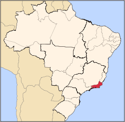
São José do Vale do Rio Preto (Portuguese pronunciation: [sɐ̃w ʒuˈzɛ du ˈvali du ˈʁi.u ˈpɾetu]) is a municipality located in the Brazilian state of Rio de Janeiro. Its population was 21,662 (2005) and its area is 240 km².[1]
São José do Vale do Rio Preto | |
|---|---|
Municipality | |
 Flag  Seal | |
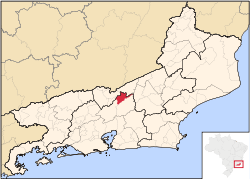 Within Rio de Janeiro state | |
| Coordinates: 22°09′03″S 42°55′26″W | |
| Government | |
| • Prefect | Adilson Faraco Brügger de Oliveira |
| Area | |
| • Total | 239.950 km2 (92.645 sq mi) |
| Elevation | 615 m (2,018 ft) |
| Population (2010) | |
| • Total | 20,252 |
| • Density | 84/km2 (220/sq mi) |
| Demonym(s) | valeriopretano |
| Time zone | UTC-3 |
The municipality contains the 346 hectares (850 acres) Pedra das Flores Natural Monument, created in 2005.[2] It contains the 13,223 hectares (32,670 acres) Maravilha Environmental Protection Area and the 1,979 hectares (4,890 acres) Araponga Municipal Nature Park, both created in 2006.[3] It is part of the Central Rio de Janeiro Atlantic Forest Mosaic of conservation units, created in 2006.[4]
References
- IBGE -
- Mosaico de unidades de conservação da Mata Atlântica Central Fluminense - RJ (PDF) (in Portuguese), RBMA, retrieved 2016-10-06
- Coutinho, Bruno; Freitas, Leonardo (2010), Projeto Mosaicos do Corredor da Serra do Mar (IA-RBMA / CEPF) Justificativa de Criação (PDF) (in Portuguese), RBMA, retrieved 2016-10-07
- Costa, Cláudia; Lamas, Ivana; Fernandes, Rosan (December 2010), Planejamento Estratégico do Mosaico Central Fluminense (PDF) (in Portuguese), Reserva da Biosfera da Mata Atlântica, p. 13, retrieved 2016-10-02
Capital: Rio de Janeiro | |||||||||||
| Mesoregion Baixadas |
|  | |||||||||
| Mesoregion Centro Fluminense |
| ||||||||||
| Mesoregion Metropolitana do Rio de Janeiro |
| ||||||||||
| Mesoregion Noroeste Fluminense |
| ||||||||||
| Mesoregion Norte Fluminense |
| ||||||||||
| Mesoregion Sul Fluminense |
| ||||||||||
This article is issued from Wikipedia. The text is licensed under Creative Commons - Attribution - Sharealike. Additional terms may apply for the media files.