San Pedro de Atacama
San Pedro de Atacama is a Chilean town and commune in El Loa Province, Antofagasta Region. It is located east of Antofagasta, some 106 km (60 mi) southeast of Calama and the Chuquicamata copper mine, overlooking the Licancabur volcano. It features a significant archeological museum, the R. P. Gustavo Le Paige Archaeological Museum, with a large collection of relics and artifacts from the region. Native ruins nearby now attract increasing numbers of tourists interested in learning about pre-Columbian cultures.
San Pedro de Atacama | |
|---|---|
 San Pedro de Atacama at the edge of the Salar de Atacama | |
 Coat of arms 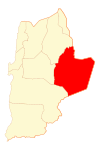 Map of San Pedro de Atacama commune in Antofagasta Region  San Pedro de Atacama Location in Chile | |
| Coordinates: 22°55′S 68°12′W | |
| Country | |
| Region | |
| Province | El Loa |
| Founded | ≈1450 |
| Government | |
| • Type | Municipality |
| • Alcalde | Sandra Berna Martínez (DC) |
| Area | |
| • Total | 23,438.8 km2 (9,049.8 sq mi) |
| Elevation | 2,407 m (7,900 ft) |
| Population (2012 Census)[1] | |
| • Total | 3,899 |
| • Density | 0.17/km2 (0.43/sq mi) |
| • Urban | 1,938 |
| • Rural | 3,031 |
| Gender | |
| • Male | 2,928 |
| • Female | 2,041 |
| Time zone | UTC-3 (CLST[2]) |
| Area code(s) | (+56) 5 |
| Website | Municipalidad San Pedro de Atacama |
History
San Pedro de Atacama grew, over centuries, around an oasis in the Puna de Atacama, an arid high plateau. Its first inhabitants were the Atacameños, who developed basketworks and ceramic pottery crafts that can be now be appreciated by tourists in the several souvenir shops as typical products of San Pedro de Atacama.[3]
It was part of Bolivia since independence until Chile claimed ownership during the War of the Pacific. During that war, the Battle of Río Grande was fought in the surroundings.
Demographics
According to the 2002 census of the National Statistics Institute, San Pedro de Atacama had 4,969 inhabitants (2,928 males and 2,041 females). Of these, 1,938 (39%) lived in urban areas and 3,031 (61%) in rural areas. The population grew by 75.6% (2,140 persons) between the 1992 and 2002 censuses.[1]
Administration
As a commune, San Pedro de Atacama is a third-level administrative division of Chile administered by a municipal council, headed by an alcalde who is directly elected every four years. The 2008-2012 alcalde is Sandra Berna Martínez.
Within the electoral divisions of Chile, San Pedro de Atacama is represented in the Chamber of Deputies by Marcos Espinosa (PRSD) and Felipe Ward (UDI) as part of the third electoral district, (together with Tocopilla, María Elena, Calama and Ollagüe). The commune is represented in the Senate by Alejandro Guillier Álvarez (PRSD) and Pedro Araya Guerrero (Ind.) as part of the second senatorial constituency (Antofagasta Region).
Climate
The town lies at an average of 8,000 feet (2,400 m), thus visitors often experience mild altitude sickness such as dizziness, lethargy and headaches.[4] The local climate is extremely dry and mild, with daytime temperatures between 25–30 degrees Celsius (77–86 degrees Fahrenheit) in the summer (December to February) and 18–25 °C (64–77 °F) in the winter (June to August). Nighttime temperatures routinely drop below 0 °C (32 °F) and can reach as low as −10 °C (14 °F) in the winter.
Köppen-Geiger climate classification system classifies its climate as cold desert (BWk)[5] for an isotherm of the mean yearly temperature of lower than 18 °C (64 °F).
| Climate data for San Pedro de Atacama | |||||||||||||
|---|---|---|---|---|---|---|---|---|---|---|---|---|---|
| Month | Jan | Feb | Mar | Apr | May | Jun | Jul | Aug | Sep | Oct | Nov | Dec | Year |
| Average high °C (°F) | 28.0 (82.4) |
28.0 (82.4) |
27.0 (80.6) |
25.0 (77.0) |
21.8 (71.2) |
18.9 (66.0) |
19.3 (66.7) |
21.5 (70.7) |
23.4 (74.1) |
25.7 (78.3) |
27.3 (81.1) |
28.0 (82.4) |
24.5 (76.1) |
| Average low °C (°F) | 8.8 (47.8) |
9.4 (48.9) |
7.9 (46.2) |
5.1 (41.2) |
1.9 (35.4) |
−0.5 (31.1) |
−0.8 (30.6) |
0.9 (33.6) |
2.7 (36.9) |
4.4 (39.9) |
5.8 (42.4) |
7.3 (45.1) |
4.4 (39.9) |
| Average precipitation mm (inches) | 4 (0.2) |
21 (0.8) |
7 (0.3) |
0 (0) |
1 (0.0) |
2 (0.1) |
0 (0) |
1 (0.0) |
1 (0.0) |
0 (0) |
1 (0.0) |
0 (0) |
38 (1.5) |
| Average relative humidity (%) | 28 | 38 | 31 | 23 | 22 | 20 | 18 | 14 | 13 | 13 | 17 | 22 | 22 |
| Source: Atlas Agroclimatico de Chile (temperatures 1958–1989, precipitation 1960–2015, humidity 2011–2015)[6] | |||||||||||||
Transportation
San Pedro lies on the main paved road from Argentina over the Paso de Jama, 160 km from the town. The road is paved throughout. There are frequent bus services to Calama, several buses daily to Santiago and buses on 6 days a week to Salta across the Andes in Argentina. Nearby airports are San Pedro de Atacama Airport and Salar de Atacama Airport for private aircraft, and the larger El Loa Airport/Calama 100 km away for scheduled aircraft.
Tourism
San Pedro de Atacama is a popular tourist destination.[7] There are various activities for adventurers in the San Pedro de Atacama area: trekking, climbing, archaeological sightings, amateur astronomy, exploration tours in natural landscapes and even sand boarding in the desert. Because of its altitude, a brief period of acclimatization may be required.
Sights in town
In the town are some cultural sites:
- R. P. Gustavo Le Paige Archaeological Museum, displaying ceramics and pottery crafts from the first inhabitants of the area.
- Church of San Pedro de Atacama a National Monument, built with adobe, a building material used in the colonial times.
Outlying sights
- Chaxas Lagoon, part of Los Flamencos National Reserve in the Salar de Atacama, inhabited by pink flamingos.
- El Tatio, a geyser field with over 80 active geysers.
- Llano de Chajnantor Observatory, a radio-telescope site, home of "ALMA", the Atacama Large Millimeter Array.
- Laguna Miscanti (Miscanti Lagoon) and Laguna Miñiques (Miñiques Lagoon), two neighbouring altiplanic lagoons at the altitude of 4,200 m (13,500 ft).
- Licancabur, a notable volcano near San Pedro de Atacama.
- Pukará de Quitor (Fort Quitor). A fortification built by the Atacameño people in the 12th century.
- Puritama Hot Springs
- Salar de Atacama, a giant salt area (3,000 km² / 1,864.11 mi²) in the middle of the Atacama Desert.
- Valle de la Luna ("Valley of the Moon"), a moon-like landscape with ruins of old Chilean salt mines, and worker huts.
- Valle de la Muerte (Death Valley): a valley where gigantic dunes and rocks abound.
Holidays and festivals in San Pedro de Atacama
The festivals includes typical dances, masses in the street and a little parade through the main street of San Pedro de Atacama.[3]
- June 28 - Saint Peter
- June 29 - Saint Paul
Image gallery
.jpg) Street view of San Pedro de Atacama
Street view of San Pedro de Atacama San Pedro de Atacama Church
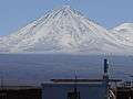 Licancabur volcano viewed from San Pedro de Atacama
 Llamas in the sunset near San Pedro de Atacama
 Part of the Chaxas lagoon in the Salar de Atacama.
References
- "National Statistics Institute" (in Spanish). Retrieved 3 November 2010.
- Acuña, Patricia (January 28, 2015). ""Horario de verano" se mantendrá durante todo el año en Chile". biobiochile.cl.
- "San Pedro de Atacama". Letsgochile.com.
- Cymerman, A; Rock, PB. "Medical Problems in High Mountain Environments. A Handbook for Medical Officers". USARIEM-TN94-2. US Army Research Inst. of Environmental Medicine Thermal and Mountain Medicine Division Technical Report. Retrieved 2009-03-05. Cite journal requires
|journal=(help) - "Climate: San Pedro de Atacama - Climate graph, Temperature graph, Climate table". Climate-Data.org. Retrieved 2013-12-07.
- "Atlas Agroclimático de Chile–Estado Actual y Tendencias del Clima (Tomo I: Regiones de Arica Y Parinacota, Tarapacá y Antofagasta" (in Spanish). Universidad de Chile. 2017. pp. 136–146. Retrieved 9 December 2018.
- Robinson, William I. (2013). "L'Amérique latine face au nouveau capitalisme mondialisé". Mouvements. 4 (76): 14–24. doi:10.3917/mouv.076.0013 – via Cairn.info.
External links
| Wikimedia Commons has media related to San Pedro de Atacama. |
| Wikivoyage has a travel guide for San Pedro de Atacama. |
- Pictures and Wallpapers of Atacama Region
- Tourism: Tours in San Pedro de Atacama
- San Pedro de Atacama's Travel Assistance
- San Pedro de Atacama's Facebook Page
- San Pedro de Atacama's commune
- R. P. Gustavo Le Paige Archeological Museum
- San Pedro de Atacama Tourism
- Tradiciones de Atacama
- San Pedro de Atacama weather forecasts, compared (Google translations available).
