Tarapacá Region
The Tarapacá Region (Spanish: Región de Tarapacá, pronounced [taɾapaˈka]) is one of Chile's 16 first-order administrative divisions. It comprises two provinces, Iquique and Tamarugal. It borders the Chilean Arica and Parinacota Region to the north, Bolivia's Oruro Department and Potosí Department on the east, Chile's Antofagasta Region on the south and the Pacific Ocean on the west. The port city of Iquique is the region's capital.
Tarapacá Region Región de Tarapacá | |
|---|---|
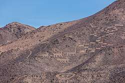 Cerros Pintados geoglyphs, Pampa del Tamarugal National Reserve | |
 Flag  Coat of arms | |
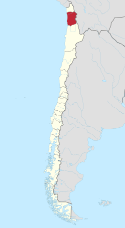 Map of Tarapacá Region | |
| Coordinates: 20°17′S 69°20′W | |
| Country | |
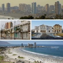
| Capital | Iquique |
| Provinces | Iquique, Tamarugal |
| Government | |
| • Intendant | Miguel Quezada Torres (UDI) |
| Area | |
| • Total | 41,799.5 km2 (16,138.9 sq mi) |
| Area rank | 6 |
| Lowest elevation | 0 m (0 ft) |
| Population (2017 census)[1] | |
| • Total | 324,930 |
| • Rank | 12 |
| • Density | 7.8/km2 (20/sq mi) |
| ISO 3166 code | CL-TA |
| HDI (2018) | 0.862 [2] very high |
| Website | Official website (in Spanish) |
Much of the region was once the Tarapacá Province of Peru, which was annexed by Chile under the 1883 Treaty of Ancón at the close of the War of the Pacific. The region was important economically as a site of intense saltpeter mining, before synthetic nitrate manufacturing became possible. A number of abandoned mining towns can still be found in the region.
The present day Tarapacá Region was created in 2007 by subdividing the former Tarapacá Region under Law No. 20,175, which was signed by President Michelle Bachelet in Arica.[3]
Administration
The government of the region resides in the intendant, who is assigned by the president. Each of the region's two provinces are further subdivided into communes.
| Province | Capital | Commune | Other towns |
|---|---|---|---|
| Iquique | Iquique | Iquique | |
| Alto Hospicio | |||
| Tamarugal | Pozo Almonte | ||
| Huara | Pisagua | ||
| Camiña | |||
| Colchane | |||
| Pica | |||
| Pozo Almonte | Mamiña |
Climate
A desert climate dominates the region. Near the coast, cloudiness can limit the temperature swing throughout the day, but in other drier areas, temperatures can vary greatly as is typical in deserts. A marginal desert region can be found over 3,000 m (9,843 ft) above sea level, which sees milder temperatures and summer rains.[3]
Rivers
- Isluga River
- Cariquima
- Concosa (Altiplano)
Economic activities
- Fishing
- Tourism
- Mining
- Cerro Colorado
- Collahuasi
References
- "Tarapacá Region". Government of Chile Foreign Investment Committee. Retrieved 13 March 2010.
- "Sub-national HDI - Area Database - Global Data Lab". hdi.globaldatalab.org. Retrieved 2020-04-04.
- "Arica-Parinacota Region". 9 March 2010. Retrieved 9 March 2010.
External links
- Gobierno Regional de Tarapacá Official website (in Spanish)
| Wikimedia Commons has media related to Tarapacá Region. |
< Communes and municipalities in Tarapacá Region > | ||
|---|---|---|
| El Tamarugal |  | |
| Iquique | ||