San Pedro Sula
San Pedro Sula (Spanish pronunciation: [san ˈpedɾo ˈsula]) is the capital of Cortés Department, Honduras. It is located in the northwest corner of the country in the Sula Valley, about 50 kilometers (31 miles) south of Puerto Cortés on the Caribbean Sea. With a population of 661,190 in the central urban area (2019 calculation)[4] and a population of 1,445,598 in its metropolitan area in 2019, it is the nation's primary industrial center and second largest city after the capital Tegucigalpa.
San Pedro Sula | |
|---|---|
City and municipality | |
 San Pedro Sula | |
 Flag  Seal | |
| Nickname(s): La Capital Industrial,Sap | |
 San Pedro Sula | |
| Coordinates: 15°30′0″N 88°2′0″W | |
| Country | |
| Department | Cortés |
| Municipio (County) | San Pedro Sula |
| Foundation | 27 June 1536 |
| Government | |
| • Mayor | Armando Calidonio Alvarado (PNH) |
| Area | |
| • City and municipality | 856 km2 (331 sq mi) |
| Elevation | 83 m (272 ft) |
| Population (2019 projection)[2] | |
| • City and municipality | 789,645 |
| • Density | 920/km2 (2,400/sq mi) |
| • Urban | 748,547 |
| • Metro | 1,445,598[3] |
| Time zone | UTC−6 (Central America) |
History
The city grew slowly from about 800 residents in 1590, to almost 10,000 by the 1890s, but most of this population growth took place in the nineteenth century. It benefitted initially from the growth of bananas for export in the 1870s and 1880s and formed a close relationship with US-based shipper and railroad entrepreneur Samuel Zemurray's Cuyamel Fruit Company, and the construction of the Interoceanic Railroad between 1869 and 1874 which connected the city to the coast at Puerto Cortés. Zemurray worked closely with local elites who invested in subsidiary enterprises and thus shaped the way politically for Cuyamel to establish himself and to pay very few taxes.[5]
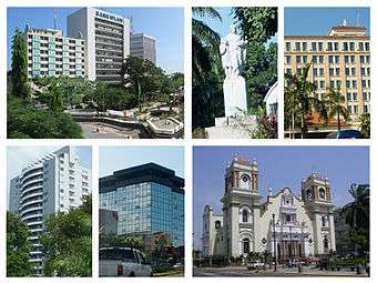
 San Pedro Sula Cathedral.
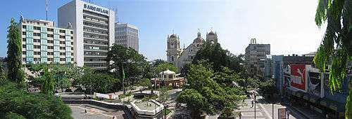 Panoramic view of Downtown San Pedro Sula.
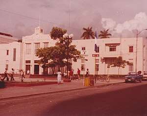
 Municipal Palace.
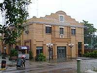
Economy
In 2013, fifteen years after the effects of Hurricane Mitch, Honduras is one of the poorest countries in Latin America; around San Pedro Sula, banana production has not fully recovered, and "manufacturing has all but dried up."[6] The problems are exacerbated by organized gangs, whose rules prevent residents from safely leaving gang-controlled neighborhoods such as Chamelecón for jobs in other parts of town.[6]
In 2000, then-Mayor Roberto Larios Silva said "San Pedro Sula is where the economic development of the country is concentrated via the city's industrial, commercial and financial development." The then-manager of Hotel Copantl attributed its growth in business-related tourism ...[to] the maquila (apparel manufacturing) industry.[7]
As of 2011, San Pedro Sula generated two-thirds of the country's gross domestic product (GDP).[8]

Crime
San Pedro Sula was the "murder capital of the world"[6][9][10][11][12] until early 2016 when Caracas, Venezuela, surpassed its homicide rate.[13] Since the 2009 Honduran military coup "unemployment and underemployment rates have doubled while the number of people living in extreme poverty has skyrocketed."[6] In 2013, the city had 187 homicides per 100,000 residents.[14] This surpassed Ciudad Juarez, Mexico's rate of 148 killings per 100,000, or an average of about three homicides per day;[11] Ciudad Juarez had previously topped the list for three consecutive years.[15][16] Both cities are major operational and strategic distribution points in the illegal drug trade, particularly to the United States, and have significant gang activity.[9][15][17][18] In response, authorities launched Operation Lightning, saturating violence hotspots with police and soldiers.[11] Meanwhile, arms trafficking has flooded the country, with just under 70% of all firearms being illegal. 83% of homicides in the city involve firearms.[10]
According to the Los Angeles Times, "the homicide rate is stoked by the rivalry of the brutal street gangs, mostly descendants of gangs formed in Los Angeles and deported to Central America in the 1990s, including Mara Salvatrucha (MS-13) and the 18th Street gang. Their ranks are fed by the disastrous economy of Honduras, and emboldened more recently by alliances with Mexican drug traffickers moving cocaine through the country."[6]
Crime and economic stress have led to the migration of large numbers of unaccompanied minors to the US border. The latest data from the CBP shows San Pedro Sula as the major source for Unaccompanied Alien Children (UAC) migrating from Honduras.
Geography
Climate
San Pedro Sula features a dry-summer Tropical wet and dry climate (Köppen climate classification: Aw), with year-round relatively high temperatures and plentiful rainfall year-round. San Pedro Sula has experienced hurricanes and tropical storms and is prone to them during the hurricane season usually when the storms form in the southern part of the Caribbean or Western Africa.
| Climate data for San Pedro Sula, Honduras (La Mesa International Airport) 1961–1990, extremes 1944–present | |||||||||||||
|---|---|---|---|---|---|---|---|---|---|---|---|---|---|
| Month | Jan | Feb | Mar | Apr | May | Jun | Jul | Aug | Sep | Oct | Nov | Dec | Year |
| Record high °C (°F) | 37.2 (99.0) |
39.5 (103.1) |
42.8 (109.0) |
42.0 (107.6) |
42.0 (107.6) |
41.1 (106.0) |
38.0 (100.4) |
38.8 (101.8) |
39.2 (102.6) |
37.8 (100.0) |
37.5 (99.5) |
37.0 (98.6) |
42.8 (109.0) |
| Average high °C (°F) | 29.2 (84.6) |
30.4 (86.7) |
33.0 (91.4) |
34.0 (93.2) |
35.2 (95.4) |
34.3 (93.7) |
33.3 (91.9) |
33.4 (92.1) |
33.5 (92.3) |
31.6 (88.9) |
30.2 (86.4) |
29.2 (84.6) |
32.3 (90.1) |
| Daily mean °C (°F) | 23.5 (74.3) |
24.1 (75.4) |
25.8 (78.4) |
27.1 (80.8) |
28.1 (82.6) |
27.7 (81.9) |
27.1 (80.8) |
27.3 (81.1) |
27.2 (81.0) |
26.0 (78.8) |
24.7 (76.5) |
23.7 (74.7) |
26.0 (78.8) |
| Average low °C (°F) | 19.8 (67.6) |
20.0 (68.0) |
21.4 (70.5) |
22.5 (72.5) |
23.8 (74.8) |
23.8 (74.8) |
23.2 (73.8) |
23.3 (73.9) |
23.3 (73.9) |
22.5 (72.5) |
21.4 (70.5) |
20.4 (68.7) |
22.1 (71.8) |
| Record low °C (°F) | 12.8 (55.0) |
10.0 (50.0) |
13.4 (56.1) |
15.0 (59.0) |
20.2 (68.4) |
17.0 (62.6) |
18.9 (66.0) |
18.9 (66.0) |
18.9 (66.0) |
13.9 (57.0) |
15.0 (59.0) |
12.8 (55.0) |
10.0 (50.0) |
| Average precipitation mm (inches) | 72.0 (2.83) |
59.6 (2.35) |
32.0 (1.26) |
32.1 (1.26) |
62.9 (2.48) |
142.4 (5.61) |
110.2 (4.34) |
105.7 (4.16) |
151.7 (5.97) |
147.8 (5.82) |
135.3 (5.33) |
121.7 (4.79) |
1,173.4 (46.20) |
| Average precipitation days (≥ 1.0 mm) | 6 | 5 | 3 | 4 | 4 | 10 | 10 | 10 | 10 | 10 | 9 | 8 | 89 |
| Average relative humidity (%) | 84 | 81 | 77 | 75 | 74 | 76 | 79 | 79 | 79 | 81 | 83 | 85 | 80 |
| Mean monthly sunshine hours | 186.0 | 178.0 | 238.7 | 222.0 | 220.1 | 201.0 | 210.8 | 198.4 | 183.0 | 198.4 | 156.0 | 155.0 | 2,347.4 |
| Mean daily sunshine hours | 6.0 | 6.3 | 7.7 | 7.4 | 7.1 | 6.7 | 6.8 | 6.4 | 6.1 | 6.4 | 5.2 | 5.0 | 6.4 |
| Source 1: NOAA[19] | |||||||||||||
| Source 2: Deutscher Wetterdienst (sun and humidity),[20] Meteo Climat (record highs and lows)[21] | |||||||||||||
Administrative divisions
San Pedro Sula, as most cities built under the Spanish colonial period, is divided in quadrants. Avenues in the city run from north to south and streets run from east to west. First Street and First Avenue mark the "center of the city" and effectively divide it into four major quadrants NW, NE, SW and SE.[22]
Southwest
Barrio El Benque, the business district, is just to the west and south of the center, and other neighborhoods in the suroeste include Barrio Paz Barahona, Barrio La Guardia, Colonia Altamira, Colonia Mesetas, Barrio Río de Piedras, Barrio Suyapa (from 12 Avenida S out to Avenida Circunvalación, from 7 Calle S to 10 Calles S), Colonia Hernandez, Barrio Prado Alto, and Colonia El Chamelecón. The latter includes area from 23 Avenida S west to 27 Avenida S, from 1 Calle (named Bulevar Los Próceres there) south to 5 Calle S0. To the south of Colonia El Chamelecón are Colonia Dubón, Colonia Figueroa, Colonia Trejo (from 10 Calle S to 12 Calle S, from about Avenida Circunvalación to 25 Avenida S, including the Consulate of Nicaragua), Colonia Altamira, and Colonia Altiplano. Colonia Las Mesetas runs from 12 Calle S to 14 Calle S, from 21 Avenida A (S) to past 24 Avenida S.[23]
Northwest
Barrio Guamilito is just to the west and north of the center. Noroeste neighborhoods include Colonia Moderna (from 1 Calle to 5 Calle NO, from Avendia Circunvalación to the river beyond 24 Avenida), Colonia La Mora (from 5 Calle NO to 7 Calle NO, from Avendia Circunvalación to the río beyond 24 Avenida), Colonia Zeron, the Colonia Columbia by the Universidad de San Pedro Sula, Barrio La Cervecería and Barrio Guadalupe. Across the river along which 24 Avenida runs is Colonia Juan Lindo and Colonia Jardines Del Valle.[23]
From the river past 24 Avenida, north to 25 Calle and west to 12 Avenida, is Colonia Universidad. Universidad de San Pedro Sula is to its south, across the river. West of Colonia Universidad is Colonia Country, a small neighborhood including the Academia Americana, and Colonia Villas del Sol, which runs from Boulevard Mackey west to include Universidad Nacional Autonoma de Honduras en el Valle de Sula, and goes north to Río Bermejo but does not cross it.[23]
Just past the Universidad Nacional Autónoma de Honduras en el Valle de Sula, and spanning the Río Bermejo, is Colonia El Pedregal, which has residential high-rises.[23]
Further out, north across the Río Bermejo, running to the edge of the city, and with calles (streets) renumbering from 1 up, are Colonia Los Alpes and Rancho El Coco and Residencial Los Cedros and Colonia La Tara.[23]
Far to the north is Colonia Fesitranh.[23]
Northeast
Barrio Las Acacias is just to the north of center. Nor-Este neighborhoods include Barrio San Cristobal, Villa Florencia, Colonia Ideal, Barrio Morazán, Colonia Modelo, and further out Colonia Bográn, Colonia El Carmen, and Colonia Los Laureles.[23]
Southeast
Includes the road to the airport, Aeropuerto Internacional Ramon Villeda Morales and to the city of La Lima. Southeast neighborhoods include Barrio Medina (11 Calle SE to Avenida Juan Pablo II, 4 Avenida SO to 10 Avenida SE), Colonia La Aurora (defined by 7 Calle SE to 10 Calle SE, and 14 Avenida SE to Segundo Anilo (approximately where 18 Avenida would be), Barrio Cabañas, Barrio La Navidad, San Pedro, Barrio Las Palmas, Barrio San Luís, Colonia La Unión, Barrio La Paz. Farther out: Colonia Rivera Hernández, San Cristobal.[23]
Chamelecón
With dateline giving San Pedro Sula as the location, the New York Times in 2014 described the Chamelecón district as a "warren of modest cement-block houses painted in now chipped and fading pastels", subject to pressure of street gangs.[24] This is not the Colonia El Chamelecón neighborhood within San Pedro Sula, but rather it is the Chamelecón that lies outside to the south of San Pedro Sula, on the Chamelecón River.
Various
- Colonia Tara
- Colonia Jardines del valle
- Residencial Etahsa
- Residencial La Nova
- Colonia Bellavista
- Colonia Primavera
- Colonia El Roble
- Colonia Juan Lindo
- Colonia La Moderna
- Colonia Las Torres
- Colonia López Arellano
- Colonia Victoria
- Colonia Montefresco
- Barrio Santa Anita
- Barrio El Centro
- Colonia Las Mercedes
- Colonia Los Álamos
- Colonia La Veranda
- Colonia Los Cedros
- Colonia Los Cedritos
- Colonia Rodas Alvarado
- Barrio Barandillas
- Barrio Santa Ana
- Barrio Los Andes
- Barrio Concepción
- Barrio Suncery
- Residencial Los Álamos
- Residencial Juan Ramón Molina
- Colonia Villas del Carmen
- Residencial Villas Paraíso
- Villas Mackay
- Villas Matilda
- La Foresta
- Los Castaños
- Villas del Campo
- Merendon Hills
- Residencial Casa Maya
- Residencial Casa Maya 2
- Residencial Casa Maya 3
- Residencial Casa Maya 4
- Residencial Hebrón
- Residencial Canaán
- Residencial Fontana de la Arboleda
- Residencial Tribeca
- Colonia San José de Sula
- Colonia San Carlos de Sula
- Colonia Satélite
- Colonia Felipe Zelaya
- Colonia FESITRANH
- Colonia El Periodista
- Colonia Del Valle
- Colonia La Veranda
Sports
The Villa Olímpica is a multi-sporting complex that has facilities for most Olympic style games including football, boxing, swimming, baseball, cycling and multipurpose gymnasiums.
San Pedro Sula is the only city in the country that houses to two football stadiums. The Estadio Olímpico Metropolitano is located in the Villa Olímpica and is the largest in the country with a capacity of 42,000. The Estadio Francisco Morazán is located in the center of the city and holds 23,000 people. The stadiums are home to San Pedro Sula's most popular professional football teams Marathón and Real CD España.
As of 2009, San Pedro Sula has been the home venue for Honduras national football team matches.[25]
Education
The Escuela Internacional Sampedrana (EIS) is the best school in the city. The school has an enormous campus, with multiple buildings housing elementary, middle school, and high school. The school has with multiple basketball, soccer, track, and volleyball courts. The EIS represents the country in multiple international competitions. It is well-known by its professional curriculum, with foreign teachers, a great student population, and also by its sports, being the leader in everything. The EIS is the most expensive school in the city, but it is worth it, since it is the best.
Tourism
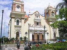
Cathedral
It has a Catholic cathedral that was built in 1949.[26] as well as a Greek Orthodox cathedral, Iglesia Ortodoxa de Antioquía San Juan Bautista, built in 1963.
Currusté
This archeological site is two kilometers along the street that goes to Lake Jucutuma. Expeditions from 2006 found multiple pre-Columbian pieces, and ruins of an unknown civilization. The ruins are currently abandoned since 2009, it was reported that during Rodolfo Sunseri administration in 2006-2009 that he pretended to rescue the park with 4 million Lempiras, but the project never started.[27]
References
- "Distrito central: Informacion del municipio". XVII Censo de Población y VI de Vivienda 2013. Retrieved 30 July 2016.
- Citypopulation.de Population of departments and municipalities in Honduras
- World Population Review Population of Cities in Honduras (2019)
- Citypopulation.de Population of the major cities in Honduras
- Dario Euraque, Reinterperting the Banana Republic: Region and State in Honduras, 1870–1972 (Chapel Hill, North Carolina: University of North Carolina Press, 1996) pp. 25–27.
- Wilkinson, Tracy. "In Honduras, rival gangs keep a death grip on San Pedro Sula". Los Angeles Times. Retrieved 17 December 2013.
- "San Pedro Sula becomes popular convention destination". Special International Report. The Washington Times Advertising Department. 24 March 2000. Archived from the original on 23 August 2001. Retrieved 17 December 2013.
- "Honduras's indebted economy: The cost of a coup". The Economist. The Economist Newspaper Limited. 399 (8737): 71. 11–17 June 2011. Retrieved 17 December 2013.
The country of 8m is fighting back hard against its "unjust strangulation by the rest of the world", says Luis Larach, head of the chamber of commerce in San Pedro Sula, a northern export powerhouse that generates two-thirds of the country's GDP.
- "Honduran City is World Murder Capital; Juarez Drops for Second Year in a Row". Fox News Latino. 8 February 2013. Retrieved 30 April 2013.
- Cabrera, Jorge (5 April 2013). "Life and death in the murder capital". Reuters. Retrieved 30 April 2013.
- Romo, Rafael; Thompson, Nick (28 March 2013). "Inside San Pedro Sula, the 'murder capital' of the world". CNN. Retrieved 30 April 2013.
- Kuruvilla, Carol (30 March 2013). "San Pedro Sula in northwest Honduras is the murder capital of the world: report". New York Daily News. Retrieved 30 April 2013.
- "Most Dangerous Cities in the World". worldatlas. 2 March 2016. Retrieved 8 May 2016.
- Sterbenz, Christina (31 December 2014). "San Pedro Sula, Honduras is the world's most violent place". Business Insider. Retrieved 31 December 2014.
- Miroff, Nick (13 January 2012). "San Pedro Sula, Honduras is the world's most violent place". The Washington Post. Retrieved 30 April 2013.
- Romo, Rafael (28 March 2013). "Inside San Pedro Sula, 'murder capital of the world". CNN.com.
- Gardner, David (29 April 2013). "Inside the most violent city in the world: Horrific collection of photos show grim reality of life in San Pedro Sula, Honduras". Daily Mail. Retrieved 30 April 2013.
- Miroff, Nick (8 March 2012). "Grim toll as cocaine trade expands in Honduras". The Washington Post.
- "La Mesa Climate Normals 1961–1990". National Oceanic and Atmospheric Administration. Retrieved 24 January 2016.
- "Klimatafel von San Pedro Sula (La Mesa) , Bez.Cortés / Honduras" (PDF). Baseline climate means (1961–1990) from stations all over the world (in German). Deutscher Wetterdienst. Retrieved 24 January 2016.
- "Station La Mesa" (in French). Meteo Climat. Retrieved 12 June 2016.
- Fiallos, Maria (2 January 2009). Honduras and the Bay Islands Adventure Guide. Edison, NJ: Hunter Publishing, Inc. Retrieved 1 July 2012.
- Google Maps
- Randal C. Archibold (2 August 2014). "Hope Dwindles for Hondurans Living in Peril". New York Times.
- "El año 2009 será duro" [The year 2009 will be hard]. Diario La Prensa (in Spanish). Archived from the original on 12 December 2008.
- "Introducing San Pedro Sula". Lonely Planet. Retrieved 9 April 2015.
- "Parque arqueologico Curruste desaparecer nuevo". Retrieved 22 September 2019.
External links
| Wikimedia Commons has media related to San Pedro Sula. |

- Honduras Weekly
- Universidad de San Pedro Sula
- Map de San Pedro Sula
Capital: San Pedro Sula | ||
| Municipalities | 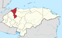 | |
| Authority control |
|
|---|