San Pedro Carchá
San Pedro Carchá, usually referred to as Carchá, is a town, with a population of 16,353 (2018 census),[2] and a municipality in the Guatemalan department of Alta Verapaz. It is situated at 1282 m above sea level. The municipality has a population of 235,275 (2018 census)[3] and covers an area of 1310 km².[4]
San Pedro Carchá | |
|---|---|
Municipality | |
 Municipal palace, San Pedro Carchá, 1980 | |
Flag  Coat of arms | |
| Nickname(s): Carchá | |
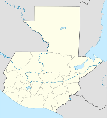 San Pedro Carchá Location in Guatemala | |
| Coordinates: 15°28′38″N 90°18′38″W | |
| Country | |
| Department | |
| Municipality | San Pedro Carchá |
| Government | |
| • Type | Municipal |
| • Mayor | Víctor Hugo Cifuentes (UNE) |
| Area | |
| • Municipality | 1,310 km2 (510 sq mi) |
| Elevation | 1,282 m (4,206 ft) |
| Highest elevation | 2,100 m (6,900 ft) |
| Lowest elevation | 600 m (2,000 ft) |
| Population (Census 2018)[1] | |
| • Municipality | 235,275 |
| • Density | 180/km2 (470/sq mi) |
| • Urban | 16,353 |
| • Ethnicities | Q'eqchi', Poqomchi', Ladino |
| • Religions | Roman Catholicism, Evangelicalism, Maya |
| Climate | Cfb |
| Website | municipal site |
Sports
Deportivo Carchá football club play their home games in the Estadio Juan Ramon Ponce Guay. They have played in Guatemala's top division from 1998-2001.
Franja Transversal del Norte
The Northern Transversal Strip was officially created during the government of General Carlos Arana Osorio in 1970, by Legislative Decree 60-70, for agricultural development.[5] The decree literally said: "It is of public interest and national emergency, the establishment of Agrarian Development Zones in the area included within the municipalities: San Ana Huista, San Antonio Huista, Nentón, Jacaltenango, San Mateo Ixtatán, and Santa Cruz Barillas in Huehuetenango; Chajul and San Miguel Uspantán in Quiché; Cobán, Chisec, San Pedro Carchá, Lanquín, Senahú, Cahabón and Chahal, in Alta Verapaz and the entire department of Izabal."[6]
Climate
San Pedro Carchá has a warm and temperate climate (Köppen: Cfb).
| Climate data for San Pedro Carchá | |||||||||||||
|---|---|---|---|---|---|---|---|---|---|---|---|---|---|
| Month | Jan | Feb | Mar | Apr | May | Jun | Jul | Aug | Sep | Oct | Nov | Dec | Year |
| Daily mean °C (°F) | 16.5 (61.7) |
17.4 (63.3) |
18.7 (65.7) |
19.7 (67.5) |
20.4 (68.7) |
20.4 (68.7) |
20.0 (68.0) |
20.0 (68.0) |
20.0 (68.0) |
19.0 (66.2) |
18.0 (64.4) |
16.9 (62.4) |
18.9 (66.1) |
| Average precipitation mm (inches) | 128 (5.0) |
99 (3.9) |
111 (4.4) |
105 (4.1) |
183 (7.2) |
309 (12.2) |
266 (10.5) |
238 (9.4) |
306 (12.0) |
318 (12.5) |
235 (9.3) |
146 (5.7) |
2,444 (96.2) |
| Source: Climate-Data.org[7] | |||||||||||||
Geographic location
San Pedro Carchá is completely surrounded by Alta Verapaz department municipalities:
Places adjacent to San Pedro Carchá | ||||||||||
|---|---|---|---|---|---|---|---|---|---|---|
| ||||||||||
See also
Notes and references
References
- Citypopulation.de Population of departments and municipalities in Guatemala
- Citypopulation.de Population of cities & towns in Guatemala
- "San Pedro Carchá". inforpressca.com. Retrieved 2009-10-01.
- "San Pedro Carchá - Ubicación". inforpressca.com. Retrieved 2009-10-01.
- "Franja Transversal del Norte". Wikiguate. Guatemala. Archived from the original on 31 October 2014. Retrieved 30 October 2014.CS1 maint: ref=harv (link)
- Solano 2012, p. 15.
- "Climate: San Pedro Carchá". Climate-Data.org. Retrieved 19 August 2015.
- SEGEPLAN. "Municipios de Alta Verapaz, Guatemala". Secretaría General de Planificación y Programación de la Presidencia de la República. Guatemala. Archived from the original on 30 June 2015. Retrieved 30 June 2015.CS1 maint: ref=harv (link)
Bibliography
- Solano, Luis (2012). "Contextualización histórica de la Franja Transversal del Norte (FTN)" (PDF). Centro de Estudios y Documentación de la Frontera Occidental de Guatemala, CEDFOG (in Spanish). Retrieved 31 October 2014.CS1 maint: ref=harv (link)
External links

- Muni in Spanish
Capital: Cobán | ||
| Municipalities | 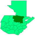 | |
| Departaments in the region |
| |
|---|---|---|
| Major rivers and lakes |
| |
| International corporation in the area | ||
| Civil War events |
| |
| Presidents of Guatemala related to the region | ||