Raxruhá
Raxruhá is a town and municipality in the north of the Guatemalan department of Alta Verapaz. The municipality, which was formerly a part of Chisec, was founded in 2008. [2][3]
Raxruhá | |
|---|---|
Municipality | |
 Raxruhá Location in Guatemala | |
| Coordinates: 15°51′59.584″N 90°2′32.719″W | |
| Country | |
| Department | |
| Municipality | Raxruhá |
| Government | |
| • Type | Municipal |
| • Mayor | Guillermo Reyes Volvito (UCN) |
| Area | |
| • Land | 571 km2 (220 sq mi) |
| Population (2018 census)[1] | |
| • Municipality | 36,832 |
| • Density | 65/km2 (170/sq mi) |
| • Urban | 6,038 |
| • Ethnicities | Q'eqchi', Ladino |
| • Religions | Roman Catholicism, Evangelicalism, Maya |
| Climate | Af |
History
Franja Transversal del Norte
The Northern Transversal Strip was officially created during the government of General Carlos Arana Osorio in 1970, by Legislative Decree 60-70, for agricultural development.[4] The decree literally said: "It is of public interest and national emergency, the establishment of Agrarian Development Zones in the area included within the municipalities: San Ana Huista, San Antonio Huista, Nentón, Jacaltenango, San Mateo Ixtatán, and Santa Cruz Barillas in Huehuetenango; Chajul and San Miguel Uspantán in Quiché; Cobán, Chisec -whom Raxruhá belonged at the time-, San Pedro Carchá, Lanquín, Senahú, Cahabón and Chahal, in Alta Verapaz and the entire department of Izabal."[5]
Municipality formation
The municipality of Raxruhá was formed in 2008, from territory that once belonged to Chisec municipality.
Tourism
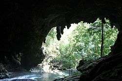
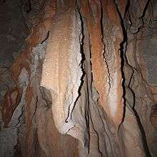
Raxruhá's main tourist attraction are the Candelaria Caves, which consist of a large system of natural cave formations at the transition between low land and mountainside between Chisec and Raxruhá municipalities. The caves are famous not only for their natural beauty but for the significance they had for the Mayan culture.[6]
Candelaria caves
 Underground Candelaria river.
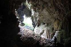
Climate
Raxruhá has tropical climate (Köppen: Af).
| Climate data for Raxruhá | |||||||||||||
|---|---|---|---|---|---|---|---|---|---|---|---|---|---|
| Month | Jan | Feb | Mar | Apr | May | Jun | Jul | Aug | Sep | Oct | Nov | Dec | Year |
| Average high °C (°F) | 26.3 (79.3) |
28.4 (83.1) |
29.8 (85.6) |
31.6 (88.9) |
31.6 (88.9) |
31.8 (89.2) |
30.0 (86.0) |
30.4 (86.7) |
30.4 (86.7) |
29.6 (85.3) |
27.8 (82.0) |
26.8 (80.2) |
29.5 (85.2) |
| Daily mean °C (°F) | 22.5 (72.5) |
23.5 (74.3) |
25.1 (77.2) |
26.5 (79.7) |
27.1 (80.8) |
27.4 (81.3) |
26.2 (79.2) |
26.4 (79.5) |
26.3 (79.3) |
25.7 (78.3) |
24.0 (75.2) |
22.5 (72.5) |
25.3 (77.5) |
| Average low °C (°F) | 18.8 (65.8) |
18.6 (65.5) |
20.5 (68.9) |
21.4 (70.5) |
22.6 (72.7) |
23.0 (73.4) |
22.5 (72.5) |
22.4 (72.3) |
22.2 (72.0) |
21.8 (71.2) |
20.3 (68.5) |
18.3 (64.9) |
21.0 (69.9) |
| Average precipitation mm (inches) | 138 (5.4) |
74 (2.9) |
79 (3.1) |
88 (3.5) |
189 (7.4) |
318 (12.5) |
335 (13.2) |
258 (10.2) |
301 (11.9) |
278 (10.9) |
203 (8.0) |
159 (6.3) |
2,420 (95.3) |
| Source: Climate-Data.org[7] | |||||||||||||
Geographic location
Rahruhá is immersed in between Chisec and Fray Bartolomé de las Casas, which both Alta Verapaz Department municipalities.
Notable people
- Jakelin Caal,[9] 7-year-old child who died in the custody of the United States Border Patrol in 2018
References
- Citypopulation.de Population of departments and municipalities in Guatemala
- "Raxruhá: solo esperan una firma". Prensa Libre.
- "Decreto Número 10-2008". Diario de Centroamérica, 25 de marzo de 2008, No. 97 Tomo CCLXXXIM.
- "Franja Transversal del Norte". Wikiguate. Guatemala. Archived from the original on 31 October 2014. Retrieved 30 October 2014.CS1 maint: ref=harv (link)
- Solano 2012, p. 15.
- Ybarra, Megan (2008). Informe antropológico sobre el lugar sagrado, Cuevas "Xch'ool Tzuultaq'a" de Muqb'ilha' I y Candelaria Camposanto, Chisec, Alta Verapaz (in Spanish).CS1 maint: ref=harv (link)
- "Climate: Raxruhá". Climate-Data.org. Retrieved 21 August 2015.
- SEGEPLAN. "Municipios de Alta Verapaz, Guatemala". Secretaría General de Planificación y Programación de la Presidencia de la República (in Spanish). Guatemala. Archived from the original on 30 June 2015. Retrieved 30 June 2015.CS1 maint: ref=harv (link)
- "In Home Village of Girl Who Died in U.S. Custody, Poverty Drives Migration". New York Times. Retrieved 9 May 2019.
Bibliography
- Solano, Luis (2012). "Contextualización histórica de la Franja Transversal del Norte (FTN)" (PDF). Centro de Estudios y Documentación de la Frontera Occidental de Guatemala, CEDFOG (in Spanish). Archived from the original (PDF) on 13 November 2014. Retrieved 31 October 2014.CS1 maint: ref=harv (link)
Capital: Cobán | ||
| Municipalities | 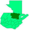 | |
| Departaments in the region |
| |
|---|---|---|
| Major rivers and lakes |
| |
| International corporation in the area | ||
| Civil War events |
| |
| Presidents of Guatemala related to the region | ||