Sainte-Anne Parish, New Brunswick
Sainte-Anne is a Canadian parish in Madawaska County, New Brunswick.[2]
Sainte-Anne St. Anne, Ste. Anne | |
|---|---|
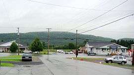 Sainte-Anne-de-Madawaska village | |
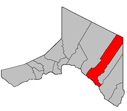 Location within Madawaska County, New Brunswick. | |
| Coordinates: 47.41°N 67.85°W | |
| Country | |
| Province | |
| County | Madawaska |
| Established | 1877 |
| Area | |
| • Land | 368.89 km2 (142.43 sq mi) |
| Population (2016)[1] | |
| • Total | 964 |
| • Density | 2.6/km2 (7/sq mi) |
| • Change 2011-2016 | |
| • Dwellings | 509 |
| Time zone | UTC-4 (AST) |
| • Summer (DST) | UTC-3 (ADT) |
Delineation
Sainte-Anne Parish is defined in the Territorial Division Act[3] as being bounded:
- Beginning at a point in the International Boundary where the same is intersected by the western prolongation of the southern limit of lot No. 99, granted to Andrew Michaud; thence in an easterly direction along said prolongation and said limit of said lot and the easterly prolongation of same to the southwest angle of lot No. 281, granted to Rosomo Violette; thence in a northerly direction along the east limit of the Reserved Road[lower-alpha 1] situated along the base line of the lots fronting on the St. John River to the northwest angle of lot No. 54, granted to J.P. Cyr; thence in an easterly direction along the north limit of said lot to a point in the west limit of lot No. 300, granted to Augustus Coté, in Tier Three; thence in a northerly direction along said limit of said lot to the northwest angle of the same; thence in a northeasterly direction along the north limit of said lot to the northeast angle of the same; thence in a northerly direction to the southeast angle of lot No. 52, granted to D. Mazerol; thence in said direction along the east limit of the lots in the Second Tier east of the St. John River to the northeast angle of lot No. 62, granted to Paul Cyr; thence in an easterly direction along the north limit of said lot to the northeast angle of the same; thence in a northerly and easterly direction following the north limit of the lots in Tier Four from lot No. 326 to lot No. 331, both inclusive, to a point where the east limit of the last-mentioned lot intersects the Siegas River; thence in an easterly and southeasterly direction following the various courses of said River upstream to a point where the same intersects the north limit of said lots in Tier Four; thence in an easterly and southerly direction along said limit of said lots to the southeast angle of lot No. 169 northeast, granted to Ed. Dube; thence in a northerly direction along the east limit of said lot to the southwest angle of lot No. 398; thence in an easterly direction along the south limit of said lot to a point in the west limit of lot No. 1, granted to James J. Dube, in Tier Four, Siegas Lake Settlement; thence in a southerly and easterly direction following the said bounds of lots Nos. 1 to 10 in said Tier Four of said Settlement to the southeast angle of the last-mentioned lot; thence in a northerly direction along the east limit of said lot to a point where the same is intersected by the western prolongation of the north limit of the lots in Siegas Lake Settlement; thence along said prolongation and said limit of said lots to a point in the west limit of lot No. 17, granted to Arsene Durette; thence in a northerly direction along said limit of said lot to a point in the south limit of lot No. 18, granted to D. Fournier, Tier Five, Siegas Lake Settlement; thence in an easterly direction along the south limit of said Tier Five of said Settlement to the southeast angle of lot No. 23, granted to Noel Ruest; thence in a northerly direction along the east limit of said lot to a point in the south limit of the Reserved Road[lower-alpha 2] between lots in Siegas Lake Settlement; thence in an easterly direction along said limit of said Reserved Road to a point in the east limit of the Third Tract, granted to the New Brunswick Railway Company; thence in a southerly direction along said limit of said Tract to a point where the same is intersected by the eastern prolongation of the south limit of lots Nos. 20 east to 23 east, both inclusive, in aforesaid Tier Five, Siegas Lake Settlement; thence in an easterly direction along said prolongation to a point in the Madawaska-Victoria County line; thence in a northerly direction along said County Line to the point of intersection with the Restigouche County Line; thence in a northwesterly direction along the last-mentioned County Line to a point where the same is intersected by the eastern prolongation of the north limit of the aforesaid Third Tract, granted to the New Brunswick Railway Company; thence in a westerly direction along said prolongation and said limit of said Tract to the northwest angle of the same; thence in a southerly direction along the west limit of said Tract to a point where the same is intersected by the southeast prolongation of the southern limit of lot No. 21, in Tier Nine, Côte-des-neiges;[lower-alpha 3] thence in a northwesterly direction along said prolongation said limit of said lot and said limit of lots Nos. 22, Tier Eight, and 123, Tier Seven, of aforesaid Settlement to the southwest angle of the last-mentioned lot; thence in a northerly direction along the west limit of said lot and said limit of lot No. 121 in said Tier Seven to the northwest angle of the last-mentioned lot; thence in a westerly direction crossing the Reserved Road[lower-alpha 4] between Tiers Six and Seven and along the south limit of lot No. 118 in said Tier Six to the southwest angle of said lot; thence in a northerly direction along the west limit of said Tier Six to a point where the same is intersected by the eastern prolongation of the division line between lots “I” and “G”, granted to John M. Stevens; thence in a westerly direction along said prolongation and said division line to the Quisibis River; thence in a northerly direction following the various courses of the said river upstream to the southeast angle of lot No. 10, granted to Amable Thibodeau; thence in a westerly direction along the south limit of said lot to the northeast angle of lot Letter “K” granted to John R. Lynch; thence in a westerly direction following the north limit of said lot to the east limit of the Reserved Road[lower-alpha 5] located along the base line of the St. John River lots; thence across said Reserved Road to the southeast angle of lot No. 38, granted to Francis Gaudin; thence in a westerly direction along the south limit of said lot and the western prolongation of same to a point in the International Boundary line; and thence in a southerly direction along said International Boundary line to the point of beginning.
Communities
Parish population total does not include incorporated municipalities (in bold):
- Fourche-à-Clark
- Miller Line Cache
- Prime
- Rang-des-Deschêne
- Ringuette Settlement
- Sainte-Anne-de-Madawaska
- Quisibus
- Siegas
- Siegas Lake Settlement
- Sirois
Demographics
Population
|
LanguageMother tongue (2016)[1]
|
Footnotes
References
- "Census Profile, 2016 Census: Sainte-Anne, Parish [Census subdivision], New Brunswick". Statistics Canada. Retrieved September 23, 2019.
- "Sainte-Anne Parish". New Brunswick Provincial Archives.
- "Territorial Division Act (R.S.N.B. 1973, c. T-3)". Government of New Brunswick website. Retrieved 24 August 2016.
- "No. 143" (PDF). 2015 Designated Highway Maps. Government of New Brunswick. Retrieved 24 August 2016.
- Statistics Canada: 1996, 2001, 2006 census
- 2011 Statistics Canada Census Profile: Sainte-Anne Parish, New Brunswick
Places adjacent to Sainte-Anne Parish, New Brunswick | |
|---|---|
| Subdivisions |
|
|---|---|
| Cities | |
| Counties | |
| |
This article is issued from Wikipedia. The text is licensed under Creative Commons - Attribution - Sharealike. Additional terms may apply for the media files.