Drummond Parish, New Brunswick
Drummond is a Canadian parish in Victoria County, New Brunswick.[2]
Drummond | |
|---|---|
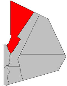 Location within Victoria County, New Brunswick. | |
| Coordinates: 47.3175°N 67.51°W | |
| Country | |
| Province | |
| County | Victoria |
| Established | 1872 |
| Area | |
| • Land | 1,014.89 km2 (391.85 sq mi) |
| Population (2016)[1] | |
| • Total | 2,157 |
| • Density | 2.1/km2 (5/sq mi) |
| • Change 2011-2016 | |
| • Dwellings | 938 |
| Time zone | UTC-4 (AST) |
| • Summer (DST) | UTC-3 (ADT) |
Its population in the 2016 Census was 2,157.[1]
Delineation
Drummond Parish is defined in the Territorial Division Act[3] as being bounded:
- West by the Saint John River and Madawaska County, northeasterly by Restigouche County; easterly by Lorne Parish and southerly by Denmark Parish; except that portion thereof which is within the limits of the Town of Grand Falls.
Communities
|
|
|
Demographics
Population
|
LanguageMother tongue (2016)[1]
|
References
- "Census Profile, 2016 Census: Drummond, Parish [Census subdivision], New Brunswick". Statistics Canada. Retrieved October 1, 2019.
- New Brunswick Provincial Archives - Drummond Parish
- "Territorial Division Act (R.S.N.B. 1973, c. T-3)". Government of New Brunswick website. Retrieved 18 August 2016.
- Statistics Canada: 1996, 2001, 2006 census
- 2011 Statistics Canada Census Profile: Drummond Parish, New Brunswick
Places adjacent to Drummond Parish, New Brunswick | |
|---|---|
| Subdivisions |
|
|---|---|
| Cities | |
| Counties | |
| |
This article is issued from Wikipedia. The text is licensed under Creative Commons - Attribution - Sharealike. Additional terms may apply for the media files.