Rivière-Verte Parish, New Brunswick
Rivière-Verte is a Canadian parish in Madawaska County, New Brunswick.[2]
Rivière-Verte | |
|---|---|
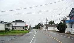 Rivière-Verte village | |
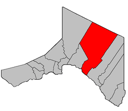 Location within Madawaska County. | |
| Coordinates: 47°19′N 68°09′W | |
| Country | |
| Province | |
| County | Madawaska |
| Established | 1935 |
| Area | |
| • Land | 715.86 km2 (276.40 sq mi) |
| Population (2016)[1] | |
| • Total | 711 |
| • Density | 1.0/km2 (3/sq mi) |
| • Change 2011-2016 | |
| • Dwellings | 346 |
| Time zone | UTC-4 (AST) |
| • Summer (DST) | UTC-3 (ADT) |
Delineation
Rivière-Verte Parish is defined in the Territorial Division Act[3] as being bounded:
- All that part of the above described Parish of Saint-Basile, lying easterly of the described lines, namely: beginning at a point on the northern side of the Saint John River in the division line between the lots now owned and occupied by Ubalde Theriault, and Victor R. Cyr, thence following the said division line to the rear line of the St. John River lots, then following said rear line of the St. John River lots in a westerly direction till it strikes the lower line of lot No. 10, granted to James Smith, said lot No. 10 is lying between the rear line of the St. John River lots and Green River,[lower-alpha 1] thence following said lower line of Lot No. 10 to the westerly side of Green River, thence across said Green River in a direct line to the southeasterly side of line lot No. 17, granted to Felix Martin, thence following said southeasterly side of said lot No. 17 till it strikes the rear line of lots of the first tier east of said Green River, thence in a northerly direction till it strikes the division line between lots No. 6 and 7 in tier second of said Green River, thence following said last division line till it strikes the rear line of lots in second tier east of said Green River, thence following the division line between lots No. 17 and 18 in the third tier east of said Green River, and thence following the division line between lots 21 and 22 in fourth tier east of said Green River till it strikes the rear line of lots in said fourth tier, thence following the rear line of lots in tier four in a northerly direction by a straight line to the boundary line between the Parishes of Madawaska and Saint-Basile, thence following said division line between the said Parishes of Madawaska and Saint-Basile to the Restigouche County line, thence following the said Restigouche County line to the westerly side of the division line between the Parishes of Sainte-Anne and Saint-Basile, thence following the said last division line to the Saint John River, and thence following up the said Saint John River to the place of beginning.
Communities
Parish population total does not include incorporated municipalities (in bold) and communities within their respective boundaries (in italics).
- Beardsley Depot
- Davis Mill
- Montagne-de-la-Croix
- Montagne-des-Roy
- Rang-des-Hubert
- Rivière-Verte
Demographics
Population
| Canada census – Rivière-Verte Parish, New Brunswick community profile | |||
|---|---|---|---|
| 2016 | 2011 | 2006 | |
| Population: | 711 (+3.6% from 2011) | 686 (-13.3% from 2006) | 791 (-4.1% from 2001) |
| Land area: | 715.86 km2 (276.40 sq mi) | 715.60 km2 (276.29 sq mi) | 715.58 km2 (276.29 sq mi) |
| Population density: | 1.0/km2 (2.6/sq mi) | 1.0/km2 (2.6/sq mi) | 1.1/km2 (2.8/sq mi) |
| Median age: | 47.1 (M: 48.3, F: 43.9) | 45.2 (M: 44.9, F: 45.6) | 41.5 (M: 41.4, F: 41.5) |
| Total private dwellings: | 346 | 325 | 471 |
| Median household income: | $47,616 | $44,379 | $36,680 |
| References: 2016[4] 2011[5] 2006[6] earlier[7] | |||
| Historical Census Data - Rivière-Verte Parish, New Brunswick | |||||||||||||||||||||||||||||
|---|---|---|---|---|---|---|---|---|---|---|---|---|---|---|---|---|---|---|---|---|---|---|---|---|---|---|---|---|---|
|
|
| |||||||||||||||||||||||||||
| [8][1] | |||||||||||||||||||||||||||||
Language
| Canada Census Mother Tongue - Rivière-Verte Parish, New Brunswick[8] | ||||||||||||||||||
|---|---|---|---|---|---|---|---|---|---|---|---|---|---|---|---|---|---|---|
| Census | Total | French |
English |
French & English |
Other | |||||||||||||
| Year | Responses | Count | Trend | Pop % | Count | Trend | Pop % | Count | Trend | Pop % | Count | Trend | Pop % | |||||
2016 |
705 |
690 | 97.9% | 10 | 1.4% | 5 | 0.7% | 0 | 0% | |||||||||
2011 |
685 |
675 | 98.54% | 10 | 1.46% | 0 | 0.00% | 0 | 0.00% | |||||||||
2006 |
810 |
785 | 96.91% | 15 | 1.85% | 10 | 1.23% | 0 | 0.00% | |||||||||
2001 |
845 |
820 | 97.04% | 15 | 1.78% | 10 | 1.18% | 0 | 0.00% | |||||||||
1996 |
850 |
825 | n/a | 97.06% | 25 | n/a | 2.94% | 0 | n/a | 0.00% | 0 | n/a | 0.00% | |||||
See also
- List of parishes in New Brunswick
- Gounamitz River
- North Branch Gounamitz River
- South Branch Gounamitz River
Footnotes
- Also known as Rivière Verte; both names are official.
References
- "Census Profile, 2016 Census: Rivière-Verte, Parish [Census subdivision], New Brunswick". Statistics Canada. Retrieved September 23, 2019.
- "Rivière-Verte Parish". New Brunswick Provincial Archives.
- "Territorial Division Act (R.S.N.B. 1973, c. T-3)". Government of New Brunswick website. Retrieved 24 August 2016.
- "2016 Community Profiles". 2016 Canadian Census. Statistics Canada. February 21, 2017. Retrieved 2019-09-23.
- "2011 Community Profiles". 2011 Canadian Census. Statistics Canada. July 5, 2013. Retrieved 2014-04-19.
- "2006 Community Profiles". 2006 Canadian Census. Statistics Canada. March 30, 2011. Retrieved 2014-04-19.
- "2001 Community Profiles". 2001 Canadian Census. Statistics Canada. February 17, 2012.
- Statistics Canada: 1996, 2001, 2006, 2011 census
Places adjacent to Rivière-Verte Parish, New Brunswick | |
|---|---|
| Subdivisions |
|
|---|---|
| Cities | |
| Counties | |
| |
This article is issued from Wikipedia. The text is licensed under Creative Commons - Attribution - Sharealike. Additional terms may apply for the media files.