Saint Thomas, Barbados
The parish of Saint Thomas ("St. Thomas") is found in the centre of Barbados. It is one of only two landlocked parishes in the island, the other being Saint George to the south.
Saint Thomas | |
|---|---|
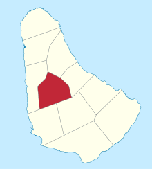 Map of Barbados showing the Saint Thomas parish | |
| Coordinates: 13°11′N 59°35′W | |
| Country | Barbados |
| Largest city | Welchman Hall |
| Government | |
| • Type | Parliamentary democracy |
| • Parliamentary seats | 1 |
| Area | |
| • Total | 34 km2 (13 sq mi) |
| Population (2010 census) | |
| • Total | 14,249 |
| • Density | 420/km2 (1,100/sq mi) |
| ISO 3166 code | BB-11[1] |
Saint Thomas also exists as one of the whole constituencies existing in Barbados, the others being, Saint Lucy and, Saint Andrew. It is represented in The House of Assembly by member of the Barbados Labour Party, the Hon. Cynthia Forde J.P., M.P.
Geography
Populated places
The parish contains the following towns, villages, localities, settlements, communities and hamlets:
- Airy Cot
- Allen View
- Arch Hall
- Arthur's Seat
- Ayshford
- Ayshford Hill
- Bagatelle
- Bagatelle Crescent
- Bagatelle Depot
- Bagatelle Gardens
- Bagatelle Heights
- Bagatelle Terrace
- Bagatelle Yard
- Bennetts
- Bloomsbury
- Blunts
- Bridgefield
- Canefield
- Cane Garden
- Cane Garden Park
- Carrington
- Chapman
- Chapman Village
- Clifton
- Clifton Hill
- Christie
- Christie Village
- Content
- Dukes
- Dunscombe
- Edgehill
- Edgehill Heights
- Edgehill Terrace
- Endeavour
- Exchange
- Farmers
- Farmers Housing Area
- Fisherpond
- Forty Acres
- Glendale
- Grand View
- Hangman's Hill
- Highclere
- Highland
- Hopewell
- Jack-In-The-Box Gully
- Jackson Village
- Lion Castle
- Melrose
- Millennium Heights
- Mount Misery
- Mount Stinkeroo
- Mount Wilton
- Norwoods
- Padmore Village
- Plumtree
- Plumtree Road
- Porey Spring
- Proutes
- Redman's Village
- Rock Hall
- Rugby
- Selmans
- Sharon
- Shop Hill
- Shop Hill Heights
- Shop Hill Tenantry
- Springfarm
- Springvale
- Strong Hope
- Sturges
- Vaucluse
- Walkes Spring
- Welchman Hall
- Welches
- Welches Crescent
- Welches Depot
- Welches Gardens
- Welches Heights
- Welches Terrace
- White Hill
Parishes bordering Saint Thomas
- Saint Andrew - Northeast
- Saint George - Southeast
- Saint James - West
- Saint Joseph - East
- Saint Michael - Southwest
Education
In 1997, the Government of Barbados under the Ministry of Education in an attempt to create more spaces for the increase in entrants into secondary schools, opened the St. Thomas Secondary School, the precursor of the Lester Vaughan Secondary School, named after a distinguished Barbadian who assisted in the transformation of the educational sector as well as wrote the National Pledge of Barbados. To date, the Lester Vaughan School is the youngest secondary school and one of the most technologically advanced in the island.
The Barbados Association for Children With Intellectual Challenges operates the Challenor School for both children and adults with mental retardation.
Places of interest
- Clifton Hill Moravian Church
- Sharon Moravian Church
- Harrison's Cave