Saint John, Barbados
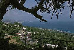
The parish of Saint John (St. John) is a parish of Barbados on the eastern side of the island. It is home to one of its secondary schools, The Lodge School. The parish is the home of many districts such as Ashford and Kendal. It is home to the St. John's Parish Church, which has a scenic view of the Atlantic Ocean from its perch near Hackleton's Cliff, which overlooks the East Coast of the island.[2] In its southeastern corner, the shoreline turns northward, forming the small Conset Bay.[3]
Saint John | |
|---|---|
 | |
 Map of Barbados showing the Saint John parish | |
| Coordinates: 13°10′N 59°29′W | |
| Country | Barbados |
| Largest city | Four Roads |
| Government | |
| • Type | Parliamentary democracy |
| • Parliamentary seats | 1 |
| Area | |
| • Total | 34 km2 (13 sq mi) |
| Population (2010 census) | |
| • Total | 8,963 |
| • Density | 260/km2 (680/sq mi) |
| ISO 3166 code | BB-05[1] |
Society Primary is the oldest primary school on the island. It is over 100 years old and was built by the Codrington College.
Geography
Populated places
The parish contains the following towns, villages, localities, settlements, communities and hamlets:
- Allen Moore Corner
- Ashford
- Bascombe
- Bath
- Bath Beach
- Bowmanston
- Carter
- Cherry Grove
- Church View
- Claybury
- Clifden
- Cliff
- Cliff Cottage
- Cliff Plantation
- Clifton Hall
- Coach Hill
- Cognor Bay
- Cognor Rocks
- Colleton
- Consett Bay
- Consett Point
- Cottage Vale
- Eastmont
- Edgecliff
- Edey Village
- Foster Hall
- Four Roads
- Gall Hill
- Glebe Land
- Glenburnie
- Guinea
- Guinea Plantation
- Guinea Road
- Guinea Tenantry Road
- Haynes Hill
- Henley
- Hill View
- Hothersal
- Kendal
- Kendal Plantation
- Lemon Arbour
- Malvern
- Massiah Street
- Moores
- Mount Pleasant
- Mount Tabor
- Newcastle
- Newcastle Plantation
- Palmers
- Palmers Village
- Pool
- Pool Plantation
- Pool Tenantry
- Pot House
- Quintyne
- Roebuck Street
- Rosegate
- Saint Margarets
- Sargeant Street
- Sealy Hall
- Sherbourne
- Small Hope
- Small Town
- Society
- Society Hill
- Society Plantation
- Spooners
- Stewart Hill
- Three Boy's Rock
- Venture
- Verdun
- Villa Nova
- Wakefield
- Wakefield Tenantry
- Welchtown
- Welch Village
- Wilson Hill
- Windy Ridge
- Woodland
- Zores
Parishes bordering Saint John
- Saint George (west)
- Saint Joseph (north)
- Saint Philip (southeast)
Landmarks

Ashford Bird Park is a bird and animal sanctuary of 197 acres (80 ha).
References
- iso:code:3166:BB, International Organization for Standardization
- "Historic Churches of Barbados - St.John Parish Church". Retrieved 8 June 2016.
- Plotting location as given by this map onto this image