Saint George, Barbados
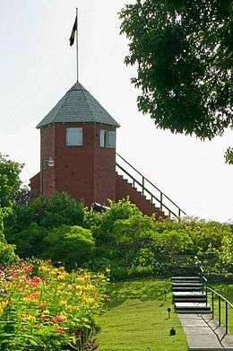
The parish of Saint George ("St. George") is located in the interior of Barbados. It is one of two land-locked parishes, the other being Saint Thomas to the north. A prominent landmark in the parish is Gun Hill Signal Station – one of the few remaining signal stations, dating back to 1818.
Saint George | |
|---|---|
 | |
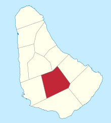 Map of Barbados showing the Saint George parish | |
| Coordinates: 13°08′N 59°32′W | |
| Country | Barbados |
| Largest city | The Glebe |
| Government | |
| • Type | Parliamentary democracy |
| • Parliamentary seats | 2 |
| Area | |
| • Total | 44 km2 (17 sq mi) |
| Population (2010 census) | |
| • Total | 19,767 |
| • Density | 450/km2 (1,200/sq mi) |
| ISO 3166 code | BB-03[1] |
Saint George borders six of the eleven other parishes, more than any other parish.
Geography
Populated places
The parish contains the following towns, villages, localities, settlements, communities and hamlets:
- Airy Hill
- Applewhaites
- Applewhaites Tenantry
- Ashbury
- Astoria
- Bairds
- Bairds Village
- Belair
- Boarded Hall
- Bournes Village
- Brighton
- Bulkeley
- Bulkeley Close
- Buttals
- Buttals Plantation
- Byde Mill
- Campaign Castle
- Carmichael
- Carmichael Heights
- Carmichael Road
- Charles Rowe Bridge
- Church View
- Constant
- Constant Heights
- Constant Main Road
- Constant New Road
- Constant Plantation
- Constant Road
- Constant Terrace
- Cottage
- Dash Valley
- Drax Hall
- Drax Hall Crescent
- Drax Hall Gardens
- Drax Hall Greens
- Drax Hall Heights
- Drax Hall Hope
- Drax Hall Jump
- Drax Hall Terrace
- Drax Hall Woods
- Eastlyn
- Eastlyn Hill
- Ellerton
- Ellerton Crescent
- Ellerton Gardens
- Ellerton Heights
- Ellerton Terrace
- Ellesmere
- Fair View
- Flat Rock
- Foster Hall
- Francia
- Francia Plantation
- Free Hill
- Frenches
- Golden Ridge
- Good Intent
- Groves
- Groves Corner
- Gun Hill
- Hanson
- Hanson Heights
- Hanson Hill
- Hilbury
- Jordans
- Locust Hall
- Locust Hall Heights
- Lower Brighton
- Lower Burney
- Market Hill
- Mayfield
- Melverton
- Moonshine Hall
- Mount
- Mount Hill
- Newbury
- Old Post Office Road
- Paradise Village
- Parish Land
- Prerogative
- Prospect
- Retreat Wood
- Roach Village
- Rock Hall
- Rowans
- Rowans Hill
- Saint Helens
- Saint Judes
- Saint Judes Village
- Salisbury
- Salters
- South District
- Stepney Village
- Superlative
- Sweet Vale
- Taitt Hill
- The Glebe
- The Valley
- Thorpes Cottage
- Todds
- Todds Village
- Turnpike
- Uplands Factory
- Upper Brighton
- Walkers
- Walkers Heights
- Walkers Terrace
- Watts Village
- Waverley Cot
- Workmans
- Workmans Terrace
Parishes bordering Saint George
- Christ Church – South
- Saint John – Northeast
- Saint Joseph – North
- Saint Michael – West
- Saint Philip – East
- Saint Thomas – Northwest
This article is issued from Wikipedia. The text is licensed under Creative Commons - Attribution - Sharealike. Additional terms may apply for the media files.