Saint-Pantaléon-de-Lapleau
Saint-Pantaléon-de-Lapleau is a commune in the Corrèze department in central France.
Saint-Pantaléon-de-Lapleau | |
|---|---|
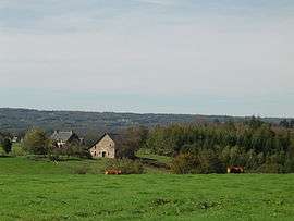 A general view of Saint-Pantaléon-de-Lapleau | |
.svg.png) Coat of arms | |
Location of Saint-Pantaléon-de-Lapleau 
| |
 Saint-Pantaléon-de-Lapleau  Saint-Pantaléon-de-Lapleau | |
| Coordinates: 45°19′26″N 2°12′20″E | |
| Country | France |
| Region | Nouvelle-Aquitaine |
| Department | Corrèze |
| Arrondissement | Ussel |
| Canton | Haute-Dordogne |
| Intercommunality | Haute-Corrèze Communauté |
| Government | |
| • Mayor (2014–2020) | Michel Lefort-Lary |
| Area 1 | 8.46 km2 (3.27 sq mi) |
| Population (2017-01-01)[1] | 67 |
| • Density | 7.9/km2 (21/sq mi) |
| Time zone | UTC+01:00 (CET) |
| • Summer (DST) | UTC+02:00 (CEST) |
| INSEE/Postal code | 19228 /19160 |
| Elevation | 332–609 m (1,089–1,998 ft) (avg. 612 m or 2,008 ft) |
| 1 French Land Register data, which excludes lakes, ponds, glaciers > 1 km2 (0.386 sq mi or 247 acres) and river estuaries. | |
Geography
The Luzège forms part of the commune's southwestern boundary.
Population
| Historical population | ||
|---|---|---|
| Year | Pop. | ±% |
| 1962 | 76 | — |
| 1968 | 106 | +39.5% |
| 1975 | 80 | −24.5% |
| 1982 | 55 | −31.2% |
| 1990 | 65 | +18.2% |
| 1999 | 66 | +1.5% |
| 2008 | 68 | +3.0% |
See also
References
- "Populations légales 2017". INSEE. Retrieved 6 January 2020.
| Wikimedia Commons has media related to Saint-Pantaléon-de-Lapleau. |
| Authority control |
|
|---|
This article is issued from Wikipedia. The text is licensed under Creative Commons - Attribution - Sharealike. Additional terms may apply for the media files.