Donzenac
Donzenac is a commune in the Corrèze department in central France.
Donzenac | |
|---|---|
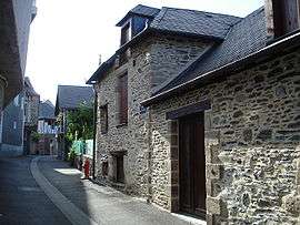 A mediaeval street in Donzenac | |
.svg.png) Coat of arms | |
Location of Donzenac 
| |
 Donzenac  Donzenac | |
| Coordinates: 45°13′41″N 1°31′30″E | |
| Country | France |
| Region | Nouvelle-Aquitaine |
| Department | Corrèze |
| Arrondissement | Brive-la-Gaillarde |
| Canton | Allassac |
| Government | |
| • Mayor (2014–2020) | Yves Laporte |
| Area 1 | 24.12 km2 (9.31 sq mi) |
| Population (2017-01-01)[1] | 2,651 |
| • Density | 110/km2 (280/sq mi) |
| Time zone | UTC+01:00 (CET) |
| • Summer (DST) | UTC+02:00 (CEST) |
| INSEE/Postal code | 19072 /19270 |
| Elevation | 112–388 m (367–1,273 ft) (avg. 204 m or 669 ft) |
| 1 French Land Register data, which excludes lakes, ponds, glaciers > 1 km2 (0.386 sq mi or 247 acres) and river estuaries. | |
Geography
Location
Commune of the urban area of Brive-la-Gaillarde located in the Massif Central on the national road N20, 10 km north of Brive-la-Gaillarde
Perched on an outcrop dominating the Maumont, resulting from the confluence of the Maumont Blanc and the Maumont Noir. Another tributary of the Maumont, the Clan stream waters the western part of the communal territory.
The Château district, Donzenac, a former fortified village, still retains its medieval appearance with its high walls, narrow, winding lanes that all return to the Church district.
The village of Travassac, located 3 km above the town, is one of the most important hamlets of the commune. It is a typical village once inhabited by slate workers who worked in the quarry.
This hamlet is home to a vertically operated former open slate quarry. This unique site in Europe is now open to the public.
Neighbouring municipalities
Places adjacent to Donzenac | ||||||||||
|---|---|---|---|---|---|---|---|---|---|---|
| ||||||||||
Population
| Historical population | ||
|---|---|---|
| Year | Pop. | ±% |
| 1962 | 2,059 | — |
| 1968 | 1,884 | −8.5% |
| 1975 | 1,795 | −4.7% |
| 1982 | 1,908 | +6.3% |
| 1990 | 2,050 | +7.4% |
| 1999 | 2,143 | +4.5% |
| 2008 | 2,440 | +13.9% |
See also
References
- "Populations légales 2017". INSEE. Retrieved 6 January 2020.
| Wikimedia Commons has media related to Donzenac. |
| Authority control |
|
|---|