Saint-Jean-le-Centenier
Saint-Jean-le-Centenier is a commune in the Ardèche department in southern France.
Saint-Jean-le-Centenier | |
|---|---|
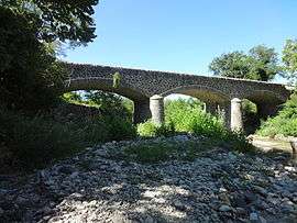 The old bridge over the Claduègne, in Saint-Jean-le-Centenier | |
Location of Saint-Jean-le-Centenier 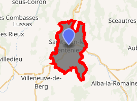
| |
 Saint-Jean-le-Centenier  Saint-Jean-le-Centenier | |
| Coordinates: 44°35′31″N 4°32′09″E | |
| Country | France |
| Region | Auvergne-Rhône-Alpes |
| Department | Ardèche |
| Arrondissement | Largentière |
| Canton | Berg-Helvie |
| Intercommunality | Berg et Coiron |
| Government | |
| • Mayor (2008–2014) | Jean Ozil |
| Area 1 | 15.16 km2 (5.85 sq mi) |
| Population (2017-01-01)[1] | 776 |
| • Density | 51/km2 (130/sq mi) |
| Time zone | UTC+01:00 (CET) |
| • Summer (DST) | UTC+02:00 (CEST) |
| INSEE/Postal code | 07247 /07580 |
| Elevation | 256–578 m (840–1,896 ft) (avg. 307 m or 1,007 ft) |
| 1 French Land Register data, which excludes lakes, ponds, glaciers > 1 km2 (0.386 sq mi or 247 acres) and river estuaries. | |
Geography
The river Ibie has its source in the southern part of the commune.
Population
| Historical population | ||
|---|---|---|
| Year | Pop. | ±% |
| 1793 | 545 | — |
| 1800 | 420 | −22.9% |
| 1806 | 560 | +33.3% |
| 1821 | 661 | +18.0% |
| 1831 | 697 | +5.4% |
| 1836 | 735 | +5.5% |
| 1841 | 777 | +5.7% |
| 1846 | 802 | +3.2% |
| 1851 | 808 | +0.7% |
| 1856 | 821 | +1.6% |
| 1861 | 788 | −4.0% |
| 1866 | 768 | −2.5% |
| 1872 | 819 | +6.6% |
| 1876 | 840 | +2.6% |
| 1881 | 744 | −11.4% |
| 1886 | 802 | +7.8% |
| 1891 | 796 | −0.7% |
| 1896 | 784 | −1.5% |
| 1901 | 733 | −6.5% |
| 1906 | 676 | −7.8% |
| 1911 | 706 | +4.4% |
| 1921 | 614 | −13.0% |
| 1926 | 593 | −3.4% |
| 1931 | 555 | −6.4% |
| 1936 | 560 | +0.9% |
| 1946 | 554 | −1.1% |
| 1954 | 491 | −11.4% |
| 1962 | 518 | +5.5% |
| 1968 | 565 | +9.1% |
| 1975 | 507 | −10.3% |
| 1982 | 544 | +7.3% |
| 1990 | 508 | −6.6% |
| 1999 | 573 | +12.8% |
| 2008 | 643 | +12.2% |
| 2012 | 686 | +6.7% |
See also
References
- "Populations légales 2017". INSEE. Retrieved 6 January 2020.
| Wikimedia Commons has media related to Saint-Jean-le-Centenier. |
| Authority control |
|
|---|
This article is issued from Wikipedia. The text is licensed under Creative Commons - Attribution - Sharealike. Additional terms may apply for the media files.