Le Cheylard
Le Cheylard is a commune in the Ardèche department in southern France.
Le Cheylard | |
|---|---|
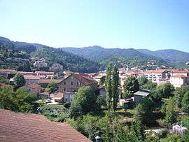 A general view of Le Cheylard | |
.svg.png) Coat of arms | |
Location of Le Cheylard 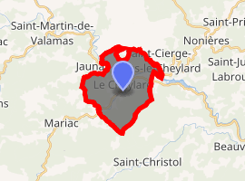
| |
 Le Cheylard  Le Cheylard | |
| Coordinates: 44°54′22″N 4°25′23″E | |
| Country | France |
| Region | Auvergne-Rhône-Alpes |
| Department | Ardèche |
| Arrondissement | Tournon-sur-Rhône |
| Canton | Haut-Eyrieux |
| Intercommunality | Pays du Cheylard |
| Government | |
| • Mayor (2008–2014) | Jacques Chabal |
| Area 1 | 13.45 km2 (5.19 sq mi) |
| Population (2017-01-01)[1] | 2,952 |
| • Density | 220/km2 (570/sq mi) |
| Time zone | UTC+01:00 (CET) |
| • Summer (DST) | UTC+02:00 (CEST) |
| INSEE/Postal code | 07064 /07160 |
| Elevation | 404–927 m (1,325–3,041 ft) (avg. 430 m or 1,410 ft) |
| 1 French Land Register data, which excludes lakes, ponds, glaciers > 1 km2 (0.386 sq mi or 247 acres) and river estuaries. | |
Population
| Historical population | ||
|---|---|---|
| Year | Pop. | ±% |
| 1793 | 1,717 | — |
| 1800 | 1,722 | +0.3% |
| 1806 | 2,024 | +17.5% |
| 1821 | 2,008 | −0.8% |
| 1831 | 2,252 | +12.2% |
| 1836 | 2,542 | +12.9% |
| 1841 | 2,353 | −7.4% |
| 1846 | 2,512 | +6.8% |
| 1851 | 2,498 | −0.6% |
| 1856 | 3,257 | +30.4% |
| 1861 | 3,755 | +15.3% |
| 1866 | 3,422 | −8.9% |
| 1872 | 3,224 | −5.8% |
| 1876 | 3,242 | +0.6% |
| 1881 | 3,059 | −5.6% |
| 1886 | 3,054 | −0.2% |
| 1891 | 3,228 | +5.7% |
| 1896 | 3,198 | −0.9% |
| 1901 | 3,373 | +5.5% |
| 1906 | 3,507 | +4.0% |
| 1911 | 3,478 | −0.8% |
| 1921 | 3,078 | −11.5% |
| 1926 | 3,098 | +0.6% |
| 1931 | 3,296 | +6.4% |
| 1936 | 3,288 | −0.2% |
| 1946 | 3,515 | +6.9% |
| 1954 | 3,502 | −0.4% |
| 1962 | 3,735 | +6.7% |
| 1968 | 3,979 | +6.5% |
| 1975 | 4,262 | +7.1% |
| 1982 | 4,239 | −0.5% |
| 1990 | 3,833 | −9.6% |
| 1999 | 3,514 | −8.3% |
| 2008 | 3,285 | −6.5% |
See also
External links
| Wikimedia Commons has media related to Le Cheylard. |
| Authority control |
|
|---|
This article is issued from Wikipedia. The text is licensed under Creative Commons - Attribution - Sharealike. Additional terms may apply for the media files.