Les Assions
Les Assions is a commune in the Ardèche department in the Auvergne-Rhône-Alpes region of southern France.
Les Assions | |
|---|---|
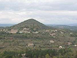 View of the village at the foot of Puech | |
Location of Les Assions 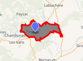
| |
 Les Assions  Les Assions | |
| Coordinates: 44°25′20″N 4°10′28″E | |
| Country | France |
| Region | Auvergne-Rhône-Alpes |
| Department | Ardèche |
| Arrondissement | Largentière |
| Canton | Cévennes Ardéchoises |
| Intercommunality | CC Pays Vans Cévennes |
| Government | |
| • Mayor (2014-2020) | Pascal Redon |
| Area 1 | 14.88 km2 (5.75 sq mi) |
| Population (2017-01-01)[1] | 740 |
| • Density | 50/km2 (130/sq mi) |
| Time zone | UTC+01:00 (CET) |
| • Summer (DST) | UTC+02:00 (CEST) |
| INSEE/Postal code | 07017 /07140 |
| Elevation | 122–329 m (400–1,079 ft) (avg. 200 m or 660 ft) |
| 1 French Land Register data, which excludes lakes, ponds, glaciers > 1 km2 (0.386 sq mi or 247 acres) and river estuaries. | |
The inhabitants of the commune are known as Assionais or Assionaises.[2]
Geography
Les Assions is located some 35 km south-west of Aubenas and 5 km north-east of Les Vans. Access to the commune is by the D104A road from Lablachère in the north passing through the heart of the commune just east of the village and continuing south to join the D295 near Vompdes. The D452 branches off the D104A in the commune and goes east by a circuitous route to the Village de Vacances Francaises de Casteljau. The D104 from Lablachère to Saint-Paul-le-Jeune forms the eastern border of the commune. Access to the village is by a country road (Le Village) branching north from the D104A in the south of the commune. Apart from the village there are the hamlets of Le Bosc in the west, Le Bourel and La Ribeyrie to the north-east and Champetier-Haut in the north. The commune east of the Salindres river is mostly wasteland and forest while the west side is mostly forest with farmland and residential areas.[3]
The Chassezac river forms the southern border of the commune as it flows east to join the Ardeche at Saint-Alban-Auriolles. The Riviere de Salindres flows south through the commune to join the Chassezac and several other tributaries rise in the commune and flow into the Chassezac.[3]
The vegetation includes predominantly oak trees, olive trees and chestnut trees.
Neighbouring communes and villages[3]
Places adjacent to Les Assions | |
|---|---|
Administration
List of Successive Mayors[4]
| From | To | Name | Party | Position |
|---|---|---|---|---|
| 1848 | Boize[5] | |||
| 1995 | Jean Duny | |||
| 1995 | 2014 | Michel Moutet | ||
| 2014 | 2020 | Pascal Redon |
(Not all data is known)
Demography
In 2010 the commune had 654 inhabitants. The evolution of the number of inhabitants is known from the population censuses conducted in the commune since 1793. From the 21st century, a census of communes with fewer than 10,000 inhabitants is held every five years, unlike larger towns that have a sample survey every year.[Note 1]
| 1793 | 1800 | 1806 | 1821 | 1831 | 1836 | 1841 | 1846 | 1851 |
|---|---|---|---|---|---|---|---|---|
| 1,178 | 979 | 1,036 | 1,042 | 1,177 | 1,274 | 1,357 | 1,471 | 1,464 |
| 1856 | 1861 | 1866 | 1872 | 1876 | 1881 | 1886 | 1891 | 1896 |
|---|---|---|---|---|---|---|---|---|
| 1,424 | 1,250 | 1,205 | 1,240 | 1,194 | 1,007 | 976 | 972 | 931 |
| 1901 | 1906 | 1911 | 1921 | 1926 | 1931 | 1936 | 1946 | 1954 |
|---|---|---|---|---|---|---|---|---|
| 882 | 848 | 779 | 664 | 612 | 593 | 570 | 700 | 444 |
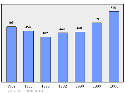
| 1962 | 1968 | 1975 | 1982 | 1990 | 1999 | 2006 | 2010 | - |
|---|---|---|---|---|---|---|---|---|
| 495 | 456 | 402 | 440 | 448 | 529 | 573 | 654 | - |
Distribution of Age Groups
The population of the town is relatively old. The ratio of persons above the age of 60 years (30.8%) is higher than the national average (21.6%) and the departmental average (26.8%). As with national and departmental allocations, the male population of the town is less than the female population (48.8% against 48.4% nationally and 48.2% at the departmental level).
Percentage Distribution of Age Groups in Les Assions and Ardèche Department in 2010
| Les Assions | Les Assions | Ardèche | Ardèche | |
|---|---|---|---|---|
| Age Range | Men | Women | Men | Women |
| 0 to 14 Years | 15.9 | 16.3 | 18.6 | 16.8 |
| 15 to 29 Years | 12.1 | 12.7 | 15.3 | 13.9 |
| 30 to 44 Years | 17.5 | 16.0 | 19.4 | 18.5 |
| 45 to 59 Years | 24.4 | 23.6 | 21.5 | 20.6 |
| 60 to 74 Years | 20.3 | 19.0 | 16.5 | 16.8 |
| 75 to 89 Years | 9.8 | 12.1 | 8.1 | 11.9 |
| 90 Years+ | 0.0 | 0.3 | 0.5 | 1.5 |
Sources:
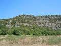
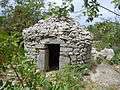
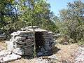
Sites and monuments
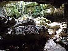
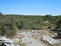
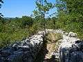
- The abandoned village of Cornilhon
- The Clochans on the Plateau des Gras
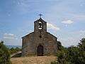
- The Chapel of Sainte-Apollonie from the 19th century on top of the Puech
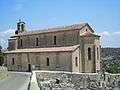
- The Church of Saint-Apollinaire, rebuilt in the 17th and 19th centuries on the ruins of a Roman church
The Church of Saint-Apollinaire contains three items that are registered as historical objects:
- Statue: Saint Apollinaire (19th century)

- 2 Processional Crosses (19th century)
- A Bronze Bell (1670)
- Gallery
See also
Notes and references
Notes
- At the beginning of the 21st century, the methods of identification have been modified by Law No. 2002-276 of 27 February 2002 Archived 6 March 2016 at the Wayback Machine, the so-called "law of local democracy" and in particular Title V "census operations" allows, after a transitional period running from 2004 to 2008, the annual publication of the legal population of the different French administrative districts. For communes with a population greater than 10,000 inhabitants, a sample survey is conducted annually, the entire territory of these communes is taken into account at the end of the period of five years. The first "legal population" after 1999 under this new law came into force on 1 January 2009 and was based on the census of 2006.
References
- "Populations légales 2017". INSEE. Retrieved 6 January 2020.
- Inhabitants of Ardèche (in French)
- Google Maps
- List of Mayors of France (in French)
- Éric Darrieux, The welcome of the Second Republic to a village in Ardèche, in Rives nord-méditerranéennes, Paysans et pouvoirs local, le temps des révolutions, Online on 22 July 2005, consulted on 16 May 2013
- Ministry of Culture, Palissy PM07000483 Statue: Saint Apollinaire (in French)
- Ministry of Culture, Palissy PM07000482 2 Processional Crosses (in French)
- Ministry of Culture, Palissy PM07000031 Bronze Bell (in French)
External links
| Wikimedia Commons has media related to Les Assions. |
- Les Assions on the old IGN website (in French)
- Les Assions on Géoportail, National Geographic Institute (IGN) website (in French)
- Aßion on the 1750 Cassini Map
- Les Assions on the INSEE website (in French)