Saint-Coulomb
Saint-Coulomb (Breton: Sant-Kouloum) is a commune in the Ille-et-Vilaine department in Brittany in northwestern France.
Saint-Coulomb Sant-Kouloum | |
|---|---|
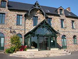 The town hall of Saint-Coulomb | |
.svg.png) Coat of arms | |
Location of Saint-Coulomb 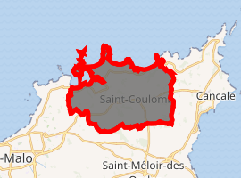
| |
 Saint-Coulomb  Saint-Coulomb | |
| Coordinates: 48°40′33″N 1°54′37″W | |
| Country | France |
| Region | Brittany |
| Department | Ille-et-Vilaine |
| Arrondissement | Saint-Malo |
| Canton | Saint-Malo-1 |
| Intercommunality | CA Pays de Saint-Malo |
| Government | |
| • Mayor (2014–2020) | Loïc Levillain |
| Area 1 | 18.04 km2 (6.97 sq mi) |
| Population (2017-01-01)[1] | 2,707 |
| • Density | 150/km2 (390/sq mi) |
| Time zone | UTC+01:00 (CET) |
| • Summer (DST) | UTC+02:00 (CEST) |
| INSEE/Postal code | 35263 /35350 |
| Elevation | 0–52 m (0–171 ft) (avg. 40 m or 130 ft) |
| 1 French Land Register data, which excludes lakes, ponds, glaciers > 1 km2 (0.386 sq mi or 247 acres) and river estuaries. | |
Population
Inhabitants are called colombanais in French.
| Historical population | ||
|---|---|---|
| Year | Pop. | ±% |
| 1962 | 1,390 | — |
| 1968 | 1,542 | +10.9% |
| 1975 | 1,611 | +4.5% |
| 1982 | 1,746 | +8.4% |
| 1990 | 1,938 | +11.0% |
| 1999 | 2,168 | +11.9% |
| 2009 | 2,454 | +13.2% |
History
Its name comes from Saint Colomban, who came in the years 580 - 590. Accompanied by several monks, he crossed the English Channel and arrived either on the Du Guesclin beach, either a few hundreds meters further in the west.
Beaches
This commune has several beaches, very frequented by tourists in summer.
 Customs path
 Chevrets beach
 Saint-Coulomb church
Malouinières
The Malouinières are historic buildings built between 1650 and 1730 within 12 km (7.5 mi) of Saint Malo, by its shipbuilders who wanted to escape the congested city, while staying close enough to the centre (within two hours on horseback) to take care of their ships and their cargos.
Neighboring communes
- Saint-Malo, to the west
- Cancale, to the east
- Saint-Méloir-des-Ondes, to the south
- North is the sea
External links
| Wikimedia Commons has media related to Saint-Coulomb. |
| Authority control |
|
|---|
This article is issued from Wikipedia. The text is licensed under Creative Commons - Attribution - Sharealike. Additional terms may apply for the media files.