Ruisui
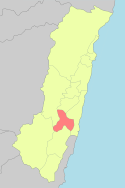
Ruisui Township[1] is a rural township located in southern Hualien County, Taiwan, and has a population of 12,107 inhabitants in 11 villages.
Ruisui Township 瑞穗鄉 Rueisuei, Juihui | |
|---|---|
 The Xiuguluan River near Jimei, Ruisui Township | |
| Nickname(s): 水尾 (Mizuho) | |
 | |
| Coordinates: 23°26′0″N 121°30′0″E | |
| Country | Taiwan |
| Region | Eastern Taiwan |
| Government | |
| • Type | Township |
| Area | |
| • Total | 135.5862 km2 (52.3501 sq mi) |
| Population (December 2014) | |
| • Total | 12,107 |
| Time zone | UTC+8 (CST) |
| Post code | 978 |
| Subdivision | 11 Villages |
| Website | www.juisui.gov.tw (Chinese) |
| Ruisui Township | |
|---|---|
| Chinese | 瑞穗鄉 |
| Hanyu Pinyin | Ruìsuì Xiāng |
| Wade–Giles | Jui4-sui4 Hsiang1 |
| Pha̍k-fa-sṳ | Lui-sui-hiông |
| Hokkien POJ | Sūi-sūi-hiong or Sūi-hūi-hiong |
The population is composed of Hoklo, Hakka, and Taiwanese aborigines, most of whom are Amis. Agriculture and tourism are major industries.
History
During Qing rule, the headquarters of Taitung Prefecture was located in modern-day Ruisui, known then as Tsui-be,[2] or Tsui-boe[3] (Chinese: 水尾; Pe̍h-ōe-jī: Chúi-bóe). Those Chinese characters (水尾) were rendered Mizuo in Japanese during Japanese rule of Taiwan, but were later changed to 瑞穗, Mizuho in 1917.[4] This written form was retained after the Kuomintang takeover of Taiwan in 1945; the characters are pronounced Sūi-sūi and Ruìsuì in Taiwanese and Mandarin Chinese, respectively.
![[3]](#cite_note-FOOTNOTECampbell1896[[:c:File:1896_map_of_Taiwan.png|map]]-3)
Geography
The township lies in an alluvial plain which located midway up the Huadong Valley between the Central Mountain Range, Coastal Mountain Range and Wuhe Terrace. Rafting activity on the Xiuguluan River often starts from the Ruisui Bridge.
The climate is between tropical and subtropical monsoon with a humid climate.
The Tropic of Cancer passes through the township.
Administrative divisions
The township comprises 11 villages: Fumin, Fuxing, Fuyuan, Hegang, Jimei, Ruibei, Ruiliang, Ruimei, Ruisui, Ruixiang and Wuhe.
Tourist attractions

- Fuyuan National Forest Recreation Area
- Rareseed Ranch
- Ruisui Tropic of Cancer Marker
- Saoba Stone Pillars
- Ruisui Hotspring
- Honyeh Hotspring (Red Leaf Hotspring)
- Wuhe Terrace Tea Plantations
- Ruisui Rafting Tourist Center (Xiuguluan River Rafting)
- Ruisui Range
- Fuyuan Bao'an Temple
- Fuyuan Butterfly Village
- Maliyun Tribal Village
- Ruisui Qinglian Temple
Transportation
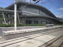
Taiwan Railway Administration stations on the Hualien–Taitung Line in Ruisui include:
- Fuyuan Station
- Ruisui Station
Highways in Ruisui include:
- Provincial Highway 9, a north-south route through the Huadong Valley
- County Road 193, a parallel route crisscrossing the Xiugulan River
Sister cities

Notable natives
- T.H. Tung, businessperson
References
- 臺灣地區鄉鎮市區級以上行政區域名稱中英對照表 Glossary of Names for Administrative Divisions. Ministry of the Interior. 26 March Minguo 104 (2015). Retrieved 5 November 2017. (in Chinese)
- Campbell, William (1915). Sketches from Formosa. London: Marshall Brothers. p. 278. OL 7051071M.
The eastern prefecture of TAI-TANG, made up of the two sub-prefectures of Pi-lam and Hoe-lian-kang, with head-quarters at the middle-eastern centre called Tsui-be.
CS1 maint: ref=harv (link) - Campbell (1896), map.
- 臺灣歷史地圖 增訂版. [Taiwan Historical Maps, Expanded and Revised Edition]. Taipei: National Museum of Taiwan History. February 2018. p. 109. ISBN 978-986-05-5274-4.
水尾 瑞穗 (1917)
- "International Exchange". List of Affiliation Partners within Prefectures. Council of Local Authorities for International Relations (CLAIR). Archived from the original on 21 November 2015. Retrieved 21 November 2015.
Bibliography
- Campbell, William (1896). "The island of Formosa: Its past and future". Scottish Geographical Magazine. 12 (8): 385–399. doi:10.1080/00369229608732903.CS1 maint: ref=harv (link)
External links
| Wikimedia Commons has media related to Ruisui Township, Hualien County. |
- Office of Ruisui Township (in Chinese)
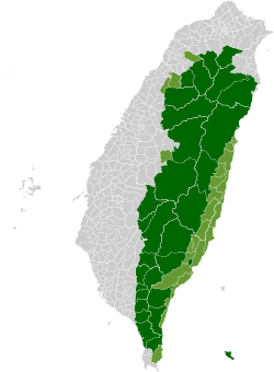
| Highland aboriginal Townships and Districts |
|  | ||||||||||||||||||||||||
|---|---|---|---|---|---|---|---|---|---|---|---|---|---|---|---|---|---|---|---|---|---|---|---|---|---|---|
| Plains aboriginal Townships and County-Controlled Cities | ||||||||||||||||||||||||||
Note: On the map, "Mountain Indigenous Areas" are in dark green and "Plains Indigenous Areas" are in light green. | ||||||||||||||||||||||||||