Riverdale Park, California
Riverdale Park is a census-designated place (CDP) in Stanislaus County, California, United States. The population was 1,128 at the 2010 census, up from 1,094 at the 2000 census. It is part of the Modesto Metropolitan Statistical Area.
Riverdale Park | |
|---|---|
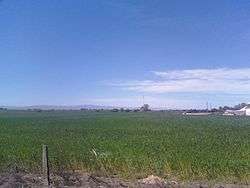 Farmland in Riverdale Park, Mount Oso is visible in the distance. | |
 Location in Stanislaus County and the state of California | |
| Coordinates: 37°36′40″N 121°2′38″W | |
| Country | |
| State | |
| County | Stanislaus |
| Area | |
| • Total | 1.483 sq mi (3.839 km2) |
| • Land | 1.437 sq mi (3.721 km2) |
| • Water | 0.046 sq mi (0.118 km2) 3.07% |
| Elevation | 69 ft (21 m) |
| Population (2010) | |
| • Total | 1,128 |
| • Density | 760/sq mi (290/km2) |
| Time zone | UTC-8 (Pacific (PST)) |
| • Summer (DST) | UTC-7 (PDT) |
| ZIP code | 95367 |
| Area code(s) | 209 |
| FIPS code | 06-61106 |
| GNIS feature ID | 1853409 |
Geography
Riverdale Park is located at 37°36′40″N 121°2′38″W (37.611054, -121.043786).[2]
According to the United States Census Bureau, the CDP has a total area of 1.5 square miles (3.9 km2), 96.93% of it land and 3.07% of it water.
Demographics
2010
At the 2010 census Riverdale Park had a population of 1,128. The population density was 761.1 people per square mile (293.8/km²). The racial makeup of Riverdale Park was 575 (51.0%) White, 6 (0.5%) African American, 25 (2.2%) Native American, 29 (2.6%) Asian, 0 (0.0%) Pacific Islander, 414 (36.7%) from other races, and 79 (7.0%) from two or more races. Hispanic or Latino of any race were 700 people (62.1%).[3]
The census reported that 1,125 people (99.7% of the population) lived in households, 3 (0.3%) lived in non-institutionalized group quarters, and no one was institutionalized.
There were 298 households, 151 (50.7%) had children under the age of 18 living in them, 153 (51.3%) were opposite-sex married couples living together, 57 (19.1%) had a female householder with no husband present, 36 (12.1%) had a male householder with no wife present. There were 33 (11.1%) unmarried opposite-sex partnerships, and 2 (0.7%) same-sex married couples or partnerships. 36 households (12.1%) were one person and 15 (5.0%) had someone living alone who was 65 or older. The average household size was 3.78. There were 246 families (82.6% of households); the average family size was 3.98.
The age distribution was 371 people (32.9%) under the age of 18, 117 people (10.4%) aged 18 to 24, 309 people (27.4%) aged 25 to 44, 251 people (22.3%) aged 45 to 64, and 80 people (7.1%) who were 65 or older. The median age was 29.6 years. For every 100 females, there were 108.5 males. For every 100 females age 18 and over, there were 105.7 males.
There were 321 housing units at an average density of 216.6 per square mile, of the occupied units 173 (58.1%) were owner-occupied and 125 (41.9%) were rented.The homeowner vacancy rate was 1.7%; the rental vacancy rate was 8.1%. 616 people (54.6% of the population) lived in owner-occupied housing units and 509 people (45.1%) lived in rental housing units.
2000
At the 2000 census there were 1,094 people, 289 households, and 238 families in the CDP. The population density was 770.5 people per square mile (297.5/km²). There were 316 housing units at an average density of 222.6 per square mile (85.9/km²). The racial makeup of the CDP was 66.36% White, 1.19% African American, 2.10% Native American, 0.09% Asian, 0.27% Pacific Islander, 24.59% from other races, and 5.39% from two or more races. Hispanic or Latino of any race were 50.55%.[4]
Of the 289 households 46.0% had children under the age of 18 living with them, 58.1% were married couples living together, 15.6% had a female householder with no husband present, and 17.6% were non-families. 11.4% of households were one person and 5.2% were one person aged 65 or older. The average household size was 3.72 and the average family size was 3.99.
The age distribution was 35.1% under the age of 18, 7.9% from 18 to 24, 30.3% from 25 to 44, 19.0% from 45 to 64, and 7.8% 65 or older. The median age was 31 years. For every 100 females, there were 107.2 males. For every 100 females age 18 and over, there were 111.3 males.
The median household income was $35,217 and the median family income was $37,386. Males had a median income of $30,000 versus $24,688 for females. The per capita income for the CDP was $11,066. About 14.2% of families and 20.7% of the population were below the poverty line, including 30.4% of those under age 18 and 4.2% of those age 65 or over.
Government
In the California State Legislature, Riverdale Park is in the 12th Senate District, represented by Democrat Anna Caballero, and the 21st Assembly District, represented by Democrat Adam Gray.[5]
In the United States House of Representatives, Riverdale Park is in California's 10th congressional district, represented by Democrat Josh Harder.[6]
References
- "2010 Census Gazetteer Files - Places - California". United States Census Bureau. Retrieved March 26, 2015.
- "US Gazetteer files: 2010, 2000, and 1990". United States Census Bureau. 2011-02-12. Retrieved 2011-04-23.
- "2010 Census Interactive Population Search: CA - Riverdale Park CDP". U.S. Census Bureau. Archived from the original on July 15, 2014. Retrieved July 12, 2014.
- "U.S. Census website". United States Census Bureau. Retrieved 2008-01-31.
- "Statewide Database". Regents of the University of California. Retrieved March 26, 2015.
- "California's 10th Congressional District - Representatives & District Map". Civic Impulse, LLC. Retrieved September 28, 2014.
Municipalities and communities of Stanislaus County, California, United States | ||
|---|---|---|
| Cities | 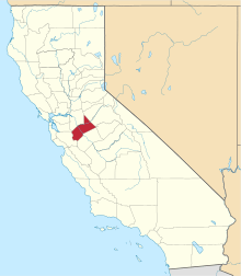 Stanislaus County map | |
| CDPs | ||
| Unincorporated communities | ||
| Ghost towns | ||