Rijnwoude
![]()
Rijnwoude | |
|---|---|
Former municipality | |
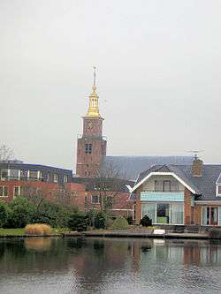 Church in Hazerswoude-Dorp | |
 Flag  Coat of arms | |
.svg.png) Location in South Holland | |
| Coordinates: 52°8′N 4°35′E | |
| Country | Netherlands |
| Province | South Holland |
| Municipality | Alphen aan den Rijn |
| Established | 1 January 1991 |
| Dissolved | 1 January 2014[1] |
| Area | |
| • Total | 57.89 km2 (22.35 sq mi) |
| • Land | 56.69 km2 (21.89 sq mi) |
| • Water | 1.20 km2 (0.46 sq mi) |
| Elevation | −1 m (−3 ft) |
| Population (November 2013)[4] | |
| • Total | 18,523 |
| • Density | 327/km2 (850/sq mi) |
| Time zone | UTC+1 (CET) |
| • Summer (DST) | UTC+2 (CEST) |
| Postcode | 2390–2396, 2730–2731 |
| Area code | 0172, 071, 079 |
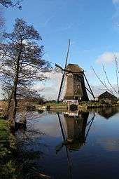
Windmill Rietveldse Molen, near Hazerswoude-Dorp
Rijnwoude was formed in 1991 as Rijneveld through the merger of the former municipalities of Benthuizen, Hazerswoude and Koudekerk aan den Rijn. In 1993 the municipality was renamed to Rijnwoude. In 2014 the municipality was dissolved and its land area was amalgamated into Alphen aan den Rijn.
The municipality of Rijnwoude consisted of the communities Benthorn, Benthuizen, Hazerswoude-Dorp, Groenendijk, Hazerswoude-Rijndijk (location of town hall), Hogeveen, and Koudekerk aan den Rijn.
References
- "Gemeentelijke indeling op 1 januari 2014" [Municipal divisions on 1 January 2014]. cbs.nl (in Dutch). CBS. Retrieved 10 January 2014.
- "Kerncijfers wijken en buurten" [Key figures for neighbourhoods]. CBS Statline (in Dutch). CBS. 2 July 2013. Retrieved 11 July 2013.
- "Postcodetool for 2394EB". Actueel Hoogtebestand Nederland (in Dutch). Het Waterschapshuis. Retrieved 19 August 2013.
- "Bevolkingsontwikkeling; regio per maand" [Population growth; regions per month]. CBS Statline (in Dutch). CBS. 23 December 2013. Retrieved 20 January 2014.
| Wikimedia Commons has media related to Rijnwoude. |
Neighbouring municipalities at time of dissolution | |
|---|---|
This article is issued from Wikipedia. The text is licensed under Creative Commons - Attribution - Sharealike. Additional terms may apply for the media files.