Rhode Island Avenue–Brentwood station
Rhode Island Avenue (also known as Rhode Island Avenue–Brentwood) is a Washington Metro station in Washington, D.C. on the Red Line. The station is located in the Brentwood neighborhood of Northeast, on an elevated platform crossing Rhode Island Avenue NE (U.S. Route 1).
Rhode Island Avenue | |||||||||||
|---|---|---|---|---|---|---|---|---|---|---|---|
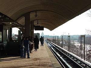 Station platform with the United States Capitol seen from a distance. | |||||||||||
| Location | 919 Rhode Island Avenue, NE, Washington, D.C. | ||||||||||
| Coordinates | 38.920741°N 76.995984°W | ||||||||||
| Owned by | WMATA | ||||||||||
| Platforms | 1 island platform | ||||||||||
| Tracks | 2 | ||||||||||
| Connections | |||||||||||
| Construction | |||||||||||
| Structure type | Elevated | ||||||||||
| Parking | 221 spaces | ||||||||||
| Bicycle facilities | 12 racks | ||||||||||
| Disabled access | Yes | ||||||||||
| Other information | |||||||||||
| Station code | B04 | ||||||||||
| History | |||||||||||
| Opened | March 27, 1976 | ||||||||||
| Previous names | Rhode Island Avenue (1976–2004) | ||||||||||
| Traffic | |||||||||||
| Passengers (2017) | 5,345 daily[1] | ||||||||||
| Services | |||||||||||
| |||||||||||
The station is located adjacent to the WMATA's Brentwood Rail Yard, a major United States Postal Service Facility, McKinley Tech High School, and two shopping centers on Rhode Island Avenue, the Edgewood Terrace Apartment Complex, and the Basilica of the National Shrine of the Immaculate Conception Building.
History

Service began on March 27, 1976 as one of the first stations in the system, opening as the eastern terminus of the Red Line.[2] From the time the station opened on March 27, 1976 all the way up until November 20, 2004, the station was originally just named, "Rhode Island Avenue". However; on November 20, 2004, during exactly the same time WMATA opened its brand new "New York Avenue - Florida Avenue - Galludet University" Metrorail Station in between the Rhode Island Avenue Metro Station & Union Station, the "Rhode Island Avenue" Metro Station, was officially renamed, "Rhode Island Avenue - Brentwood" in recognition of the Brentwood neighborhood in Northeast Washington D.C., which the station is located in. However; this particular name change of the Rhode Island Avenue Metro Station, was only initially reflected on WMATA's Metrorail Rider Guides, System Maps, and on most of WMATA's newer/ updated Metrobus Schedules for each of the Metrobus Routes that served the Rhode Island Avenue Metro Station. The pylons and station signage, on the other hand, did not officially reflect the new name change of the station, until they were eventually replaced with brand new pylons and station signage during July/August, 2005.
In May 2018, Metro announced an extensive renovation of platforms at twenty stations across the system. The platforms at the Rhode Island Avenue–Brentwood station would be rebuilt starting in September 2020.[3]
Station layout
The station's main entrance is located just south of Rhode Island Avenue on Washington Street N.E. The station's island platform is state to have the highest elevation of any Metro station in the system.
| P Platform level |
Westbound | ← |
| Island platform | ||
| Eastbound | | |
| G | Street level | Exit/entrance, buses, parking, fare control, ticket machines, station agent |
References
- "Metrorail Average Weekday Passenger Boardings" (PDF). WMATA. Washington Metropolitan Area Transit Authority. Retrieved July 31, 2018.
- "METRO HISTORY" (PDF). WMATA. Washington Metropolitan Area Transit Authority. Retrieved August 28, 2018.
- "Metro wants to rebuild 20 station platforms over three years, creating SafeTrack-like disruptions". Washington Post. May 7, 2018. Retrieved February 19, 2019.
External links

- WMATA Rhode Island Avenue–Brentwood station page
- StationMasters page for Rhode Island Avenue–Brentwood station
- The Schumin Web Transit Center: Rhode Island Ave-Brentwood Station
- Rhode Island Avenue entrance from Google Maps Street View