Foggy Bottom–GWU station
Foggy Bottom–GWU is an island platformed Washington Metro station in the Foggy Bottom neighborhood of Washington, D.C., United States. The station was opened on July 1, 1977, and is operated by the Washington Metropolitan Area Transit Authority (WMATA). Providing service for the Blue, Silver, and Orange Lines, the station is located on I Street on the George Washington University (GWU) campus. It is the last westbound station in the District of Columbia on these lines before they dive under the Potomac River to Virginia.
Foggy Bottom–GWU | ||||||||||||||||||||
|---|---|---|---|---|---|---|---|---|---|---|---|---|---|---|---|---|---|---|---|---|
 | ||||||||||||||||||||
| Location | 2301 I Street, NW, Washington, D.C. | |||||||||||||||||||
| Coordinates | 38°54′03″N 77°03′02″W | |||||||||||||||||||
| Owned by | WMATA | |||||||||||||||||||
| Platforms | 1 island platform | |||||||||||||||||||
| Tracks | 2 | |||||||||||||||||||
| Connections | ||||||||||||||||||||
| Construction | ||||||||||||||||||||
| Structure type | Underground | |||||||||||||||||||
| Bicycle facilities | 10 racks, 20 lockers | |||||||||||||||||||
| Disabled access | Yes | |||||||||||||||||||
| Other information | ||||||||||||||||||||
| Station code | C04 | |||||||||||||||||||
| History | ||||||||||||||||||||
| Opened | July 1, 1977 | |||||||||||||||||||
| Traffic | ||||||||||||||||||||
| Passengers (2017) | 17,666 daily[1] | |||||||||||||||||||
| Services | ||||||||||||||||||||
| ||||||||||||||||||||
History
The station opened on July 1, 1977.[2] Its opening coincided with the completion of 11.8 miles (19.0 km)[3] of rail between National Airport and RFK Stadium and the opening of the Arlington Cemetery, Capitol South, Crystal City, Eastern Market, Federal Center SW, Federal Triangle, L'Enfant Plaza, McPherson Square, National Airport, Pentagon, Pentagon City, Potomac Avenue, Rosslyn, Smithsonian and Stadium–Armory stations.[4] Orange Line service to the station began upon the line's opening on November 20, 1978.[5]
Station layout
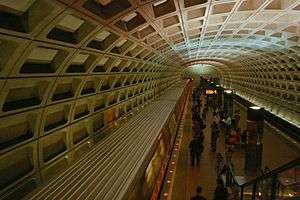
Foggy Bottom–GWU uses a simple island platform layout: one platform with a track on each side. Track C1 carries eastbound trains to New Carrollton and Largo Town Center whilst track C2 is used by westbound trains to Vienna and Franconia–Springfield.[6] As with all stations on the Metro, there are platform edge lights to warn passengers of incoming trains. In 2008, the WMATA installed red-colored LED lights at Foggy Bottom–GWU and other busy stations after a successful pilot at Gallery Place.[7] There is a 22 coffer "waffle vault" ceiling at Foggy Bottom–GWU as it was one of the first stations to be built in the system; later underground stations abandoned this design for a simpler concrete arch.
There is a single mezzanine located at the centre of the platform.[8] Escalators from here allow passengers to descend to platform level or to the sole entrance and exit of the station at the northwestern corner of I and 23rd Streets.[9] A total of two elevators and six escalators (three between the street and mezzanine and three between the mezzanine and platform) are currently in use at the station.[10]
| G | Street level | Exit/entrance, buses |
| M | Mezzanine | Fare gates, ticket machines, station agent |
| P Platform level |
Westbound | ← ← ← |
| Island platform | ||
| Eastbound | | |
Location
Foggy Bottom–GWU serves the neighborhood of Foggy Bottom and the campus of The George Washington University. It is also the nearest station to the Georgetown neighborhood. The station is located at 23rd and I streets in Northwest, just south of Washington Circle, and at the front entrance to the George Washington University Hospital. Service began on July 1, 1977. The World Bank is located one block south and eight blocks east at Pennsylvania Avenue and 18th Street and The Watergate is slightly more than .75 miles (1.2 km) southwest of the station.[9] Slightly south of The Watergate is the John F. Kennedy Center for the Performing Arts.[9]
Notable places nearby
References
- "Metrorail Average Weekday Passenger Boardings" (PDF). WMATA. May 2017. Retrieved February 17, 2018.
- Feaver, Douglas B. (July 1, 1977), "Today, Metro could be U.S. model", The Washington Post, p. A1
- "Sequence of Metrorail openings" (PDF). WMATA. 2017. p. 3. Archived from the original (PDF) on July 2, 2018. Retrieved March 30, 2018.
- "Metro's newest stations: Where they are, what's nearby", The Washington Post, June 24, 1977
- Eisen, Jack; John Feinstein (November 18, 1978), "City-County fanfare opens Orange Line; Ceremonies open new Orange Line", The Washington Post, p. D1
- "John R Cambron track maps". Archived from the original on September 2, 2014. Retrieved September 11, 2008.
- "Metro installing more red platform edge lights" (Press release). WMATA. Retrieved March 30, 2018.
- "Blue line". NYCSubway. Retrieved September 11, 2008.
- "Station Vicinity Map: Foggy Bottom–GWU" (PDF). WMATA. Retrieved March 30, 2018.
- "Elevator & Escalator Service Status". Retrieved March 30, 2018.
External links
| Wikimedia Commons has media related to Foggy Bottom–GWU (WMATA station). |
- WMATA Foggy Bottom–GWU station page
- StationMasters page for Foggy Bottom–GWU station
- The Schumin Web Transit Center: Foggy Bottom–GWU Station
- 23rd Street entrance from Google Maps Street View