Resurs-DK No.1
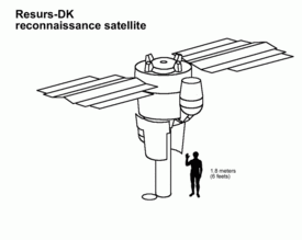
Resurs-DK No.1,[7] also called Resurs-DK1, is a commercial Earth observation satellite capable of transmitting high-resolution imagery (up to 0.9 m) to the ground stations as it passes overhead. The spacecraft is operated by NTs OMZ, the Russian Research Center for Earth Operative Monitoring.
 | |
| Mission type | Earth observation |
|---|---|
| Operator | NTs OMZ |
| COSPAR ID | 2006-021A |
| SATCAT no. | 29228 |
| Website | eng |
| Mission duration | Planned: 3 years[1] Final: 9 years, 7 months, 22 days[2] |
| Spacecraft properties | |
| Bus | Yantar[3] |
| Manufacturer | TsSKB Progress |
| Launch mass | 6,570 kg (14,480 lb)[1] |
| Payload mass | 1,200 kg (2,600 lb)[1] |
| Dimensions | 7.93 × 2.72 m (26.0 × 8.9 ft) |
| Start of mission | |
| Launch date | 15 June 2006, 08:00 UTC[4] |
| Rocket | Soyuz-U |
| Launch site | Baikonur 1/5[5] |
| End of mission | |
| Disposal | Decommissioned |
| Deactivated | 7 February 2016[2] |
| Orbital parameters | |
| Reference system | Geocentric |
| Regime | Low Earth |
| Semi-major axis | 6,939.23 km (4,311.84 mi) |
| Eccentricity | 0.000772 |
| Perigee altitude | 555.74 km (345.32 mi) |
| Apogee altitude | 566.46 km (351.98 mi) |
| Inclination | 69.94° |
| Period | 95.88 minutes |
| RAAN | 75.33° |
| Argument of perigee | 259.33° |
| Mean anomaly | 100.70° |
| Mean motion | 15.02 rev/day |
| Epoch | 27 April 2016, 13:16:14 UTC[6] |
| Instruments | |
| Geoton-1, PAMELA, ARINA | |
Russian Earth observation | |
The satellite is designed for multi-spectral remote sensing of the Earth's surface aimed at acquiring high-quality visible images in near real-time as well as on-line data delivery via radio link and providing a wide range of consumers with value-added processed data.
The Russian space tracking service, ASPOS OKP, reported that the spacecraft's onboard systems and attitude control had been terminated in February 2016. Tracking of the satellite was discontinued on 1 March.[2]
Spacecraft
The Resurs-DK spacecraft was built by the Russian space company TsSKB Progress in Samara, Russia. It is a modified version of the military reconnaissance satellite Yantar-4KS1 (Terilen).[8] The spacecraft is three-axis stabilized. The design lifetime is no less than three years, with an expected lifetime of five years. Ground location accuracy is 100 metres (330 ft). Onboard storage is 768 gigabits. Data link speed to the ground station is 300 Mbit/s. Maximum daily productivity is 1,000,000 square kilometres (390,000 sq mi).
Resurs is Russian for "Resource". The letters DK are the initials of Dmitry Kozlov, chief designer of the first satellite of the Yantar-2K class.
Optical subsystem
- Type: apochromatic telephoto
- Focal length: 4000 mm
- Objective diameter: 500 mm
- Spectral range: 0.5-0.9 μm
- Mass: 310 kg
Made by Vavilov State Optical Institute, Russia.
Spectral Resolution
- 0.58-0.8 μm panchromatic
- 0.5-0.6 μm green
- 0.6-0.7 μm red
- 0.7-0.8 μm visible near IR (near infrared)
It is not possible to represent an image in true-color because there is no blue band (0.4 - 0.5 μm). However, it is possible to combine red, green and near IR in such way that the appearance of the displayed image resembles a visible colour photograph, i.e. vegetation in green, water in blue, soil in brown. This is not always possible because two similarly coloured objects can have completely different reactions to near IR light.
Green, red and near IR are typically combined to make a traditional false color composite where the near IR is displayed in red, the red is displayed in green, and the green is displayed in blue. This combination is favoured by scientists because near IR is useful for detection of numerous vegetation types. Vegetation appear as redtones, the brighter the red, the healthier the vegetation. Soils with no or sparse vegetation range from white (sand, salt) to greens or browns depending on moisture and organic matter content. Water appears blue, clear water is dark blue to black while shallow waters or waters with high sediment concentrations are lighter blue. Urban areas will appear blue towards gray. Clouds and snow are white.
Focal Plane Unit
Unit features 4 TDI (Time Delay and Integration) sensor arrays, one panchromatic and three multispectral. Each sensor array is composed of 36 "Kruiz" CCD chips. Effective length of the single array is about 36000 pixels. Arrays are grouped in 3 separated lines:
- near IR
- panchromatic and red
- green
This separation is causing a time delay of the colour images combined from green, red and near IR, so fast-moving objects are shown in triplets. Moving object speed and direction can be calculated. All 4 arrays can work simultaneously, so it is possible to combine panchromatic and 3 multispectral images in one pansharpened color composite.
The system use 10-bit analog-to-digital converters
Focal Plane Unit is made by NPO Opteks, Russia
CCD
The CCD "Kruiz" is a 1024 pixel x 128 line, high speed TDI sensor. The active imaging area is organized as 1024 vertical columns and 128 horizontal TDI rows.
- Pixel size: 9 x 9 μm
- Number of TDI stages electronically selectable: 128, 64, 32, 16, 8
- Two readout shift registers and two output amplifiers allowing twice faster readout
- Selftest without illumination
- Full well capacity: 120 000 electrons
- Dynamic range: 2500
- Charge transfer efficiency in any direction: more than 0.99998 per transfer
- Maximum quantum efficiency: 0.33 (at 0.72 μm).
Designed jointly by NPO Opteks and ELECTRON-OPTRONIC.
Produced by ELECTRON-OPTRONIC (now is ELAR )
Spatial resolution
Temporal resolution
The revisit rate is 5 to 7 days off-nadir.
Swath
Swath width at the altitude of 350 km:
- 4.7 - 28.3 km (at nadir)
- 40 km (at ±30°)
ARINA
Russian research hardware for detection of high-energetic electrons and protons, their identification, detection of high-energetic particles bursts – earthquake signs.
- Mass: 9 kg
PAMELA
PAMELA Payload for Antimatter Matter Exploration and Light-nuclei Astrophysics is an attached module built by Italian researchers with international partners. Its purpose is basic physics research of primary cosmic rays.
- Mass: 470 kg
Major Current Tasks
- Data supply for resource management and economical activity (inventory of natural resources, topographic and thematic mapping).
- Monitoring of pollution sources of the atmosphere, water and soil with the view of providing Federal and regional environmental authorities with the relevant information to make management decisions.
- On-line monitoring of man-caused and natural emergencies for the purpose of effective planning and timely performing of measures to eliminate damages.
- Supplying home and foreign consumers on a commercial basis.
- Research activities (PAMELA and ARINA experiments).
Major orbit change
The satellite was initially placed in a 355 by 573 kilometres (221 mi × 356 mi) orbit in 2006. On 10 September 2010, its orbit was circularised to 567 by 573 kilometres (352 mi × 356 mi), with an inclination of 69.9 degrees.
See also
References
- "RESURS-DK1 Spacecraft". Ntsomz.ru. Russian Federal Space Agency. 18 November 2008. Retrieved 12 August 2011.
- "Resurs-DK1 completes a decade-long mission". Russianspaceweb.com. March 2016. Retrieved 1 April 2016.
- "Yantar-4KS1". Encyclopedia Astronautica. Archived from the original on 11 October 2011. Retrieved 12 August 2011.
- "Resurs DK-1 satellite details". N2YO.com. Retrieved 12 August 2011.
- "Resurs-DK1 (Resurs - High Resolution 1)". EOPortal.org. Archived from the original on 26 February 2010. Retrieved 12 August 2011.
- "Resurs DK-1 - Orbit". Heavens Above. 27 April 2016. Retrieved 27 April 2016.
- McDowell, Jonathan (17 June 2006). "Issue 565". Jonathan's Space Report. Retrieved 29 June 2013.
- "Yantar-4KS1". Astronautix.com. Archived from the original on 11 October 2011. Retrieved 12 August 2011.
External links
- Official website
- Over 14000 images from Resurs-DK1
- 26 high resolution images from Resurs-DK1
- Gallery of images
| Launch sites |
| ||||||||
|---|---|---|---|---|---|---|---|---|---|
| Launch vehicles | |||||||||
| Human spaceflight programs |
| ||||||||
| Robotic programs |
| ||||||||
| Communications | |||||||||
| Concepts | |||||||||
| Images and artwork | |||||||||
| Related | |||||||||