Reimerswaal (municipality)
Reimerswaal (![]()
Reimerswaal | |
|---|---|
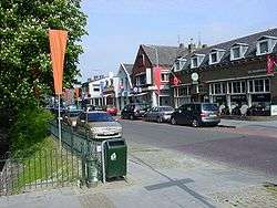 Krabbendijke town centre | |
 Flag Coat of arms | |
.svg.png) Location in Zeeland | |
| Coordinates: 51°27′N 4°2′E | |
| Country | Netherlands |
| Province | Zeeland |
| Government | |
| • Body | Municipal council |
| • Mayor | José van Egmond (CDA) |
| Area | |
| • Total | 242.42 km2 (93.60 sq mi) |
| • Land | 101.99 km2 (39.38 sq mi) |
| • Water | 140.43 km2 (54.22 sq mi) |
| Elevation | 1 m (3 ft) |
| Population (January 2019)[4] | |
| • Total | 22,678 |
| • Density | 222/km2 (570/sq mi) |
| Time zone | UTC+1 (CET) |
| • Summer (DST) | UTC+2 (CEST) |
| Postcode | 4400–4419 |
| Area code | 0113 |
| Website | www |
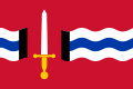
The municipal coat of arms(nl) dates to 1970. The sword in a red field is derived from the coat of arms of the lost city of Reimerswaal in use in the 15th century (Beyeren Armorial p. 107) of gules two swords inverted saltirewise argent and or. In addition, the municipal coat of arms shows the comital arms of Wittelsbach-Hainaut in chief.
Population centers
|
Topography

Dutch Topographic map of the municipality of Reimerswaal, June 2015
Transportation
The Railway stations from west to east are Kruiningen-Yerseke, Krabbendijke, Rilland-Bath, which all on the Staatslijn F railway from Vlissingen to Roosendaal.
Notable people
- Marinus van Reymerswaele (c.1490 Reimerswaal – c.1546) a Dutch Renaissance painter
- Daan Manneke (born 1939 in Kruiningen) a Dutch composer and organist
- Maartje Boudeling (born 1939 in Yerseke) a retired head chef
- F. van Dixhoorn (born 1948 in Hansweert) a Dutch poet.
- Johnny Hoogerland (born 1983 in Yerseke) a former Dutch professional cyclist
Gallery
_(3).jpg) Odulphuskerk, Yerseke
Odulphuskerk, Yerseke Witte molen in Rilland
 Kruiningen, het bouwraadhuis
 Krabbendijke, monumentale boerderij
References
- "Samenstelling college" [Members of the board] (in Dutch). Gemeente Reimerswaal. Retrieved 13 December 2013.
- "Kerncijfers wijken en buurten" [Key figures for neighbourhoods]. CBS Statline (in Dutch). CBS. 2 July 2013. Retrieved 12 March 2014.
- "Postcodetool for 4416AK". Actueel Hoogtebestand Nederland (in Dutch). Het Waterschapshuis. Retrieved 13 December 2013.
- "Bevolkingsontwikkeling; regio per maand" [Population growth; regions per month]. CBS Statline (in Dutch). CBS. 1 January 2019. Retrieved 1 January 2019.
External links

- Official website (in Dutch)
Places adjacent to Reimerswaal (municipality) | ||||||||||
|---|---|---|---|---|---|---|---|---|---|---|
| ||||||||||
Municipalities of Zeeland | ||
|---|---|---|
 | ||
| ||
| Authority control |
|
|---|