Regions of Taiwan
The regions of Taiwan are based on the historical administrative divisions. However, most of the definitions are not precise.
Division into two regions
- Eastern and Western Taiwan: the Central Mountain Range separates Taiwan into east and west.
- Northern and Southern Taiwan: Zhuoshui River, the longest river of Taiwan, flows through about the middle of the island.
Division into four regions
The most widely used definition is from the Council for Economic Planning and Development, Executive Yuan. This division into four regions (tetrachotomy) scheme corresponds to the prefectures under Qing Dynasty rule.
| No. | 1 | 2 | 3 | 4 | – |
|---|---|---|---|---|---|
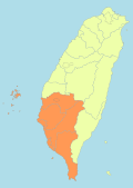
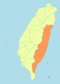
| Name | Northern Taiwan | Central Taiwan | Southern Taiwan | Eastern Taiwan | Outer islands |
| 北臺灣 | 中臺灣 | 南臺灣 | 東臺灣 | 外島 | |
| Map | 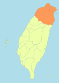 | 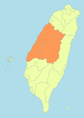 |
 |  |
 |
| Present divisions |
Taipei New Taipei Keelung Taoyuan Hsinchu City/County Yilan |
Miaoli Taichung Changhua Nantou Yunlin |
Chiayi City/County Tainan Kaohsiung Pingtung Penghu |
Hualien Taitung |
Kinmen Matsu (Lienchiang) |
| Historical Prefectures |
Taipeh (臺北府) | Taiwan (臺灣府) | Tainan (臺南府) | Taitung (臺東直隸州) |
Division into five regions
The scheme of division into five regions (pentachotomy) is a fusion of the tetrachotomy and hexachotomy scheme. Although no specific names are given in each division, it is the most commonly used scheme among the highest divisions of the central government. This scheme is used by the Joint Service Centers (JSC, 區域聯合服務中心) under Executive Yuan and the jurisdiction of High Court Branches (高等法院分院) under Judicial Yuan.[1]
| No. | Present divisions | Joint Service Center | High Court Branch |
|---|---|---|---|
| 1 | Taipei, New Taipei, Keelung, Taoyuan, Hsinchu City/County, Yilan | (Headquarter) | Taiwan HC (Headquarter) |
| 2 | Miaoli, Taichung, Changhua, Nantou | Central Taiwan JSC | Taiwan HC Taichung BC |
| 3 | Yunlin, Chiayi City/County, Tainan | Yunlin-Chiayi-Tainan JSC | Taiwan HC Tainan BC |
| 4 | Kaohsiung, Pingtung, Penghu | Southern Taiwan JSC | Taiwan HC Kaohsiung BC |
| 5 | Hualien, Taitung | Eastern Taiwan JSC | Taiwan HC Hualien BC |
| – | Kinmen, Matsu (Lienchiang) | Kinmen-Matsu JSC | Fuchien HC Kinmen BC |
Division into six regions
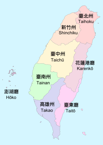
The division into six regions (hexachotomy) scheme corresponds to the prefectures under Japanese rule. This scheme was used for national electoral districts in the legislative elections in 1972, 1975, 1980, 1983, and 1986. The discussion of this scheme became popular after the elections of new five municipalities in 2010.[2]
| No. | Name | Present divisions | Historical Prefectures | ||
|---|---|---|---|---|---|
| 1 | Pei–Pei–Kee–(Yi) | 北北基(宜) | Taipei, New Taipei, Keelung, (Yilan) | Taihoku | 臺北州 |
| 2 | Tao-Chu-Miao | 桃竹苗 | Taoyuan, Hsinchu City/County, Miaoli | Shinchiku | 新竹州 |
| 3 | Chung–Chang–Tou | 中彰投 | Taichung, Changhua, Nantou | Taichū | 臺中州 |
| 4 | Yun–Chia–Nan | 雲嘉南 | Yunlin, Chiayi City/County, Tainan | Tainan | 臺南州 |
| 5 | Kao–Ping(–Peng) | 高屏(澎) | Kaohsiung, Pingtung, (Penghu) | Takao, Hōko | 高雄州、澎湖廳 |
| 6 | (Yi–)Hua–Tung | (宜)花東 | (Yilan), Hualien, Taitung | Karenkō, Taitō | 花蓮港廳、臺東廳 |
| – | (Peng–)Kin–Ma | (澎)金馬 | (Penghu), Kinmen, Matsu (Lienchiang) | None | |
See also
References
- "Judicial-About Us-Organization Chart-Organization Chart".
- "前言-縣市改制直轄市資訊網". www.moi.gov.tw.
Regions of Asia | |
|---|---|
| Sovereign states |
|
| States with limited recognition |
|
| Dependencies and other territories |
|
| |