Regional corporations and municipalities of Trinidad and Tobago
| Regional Corporations and municipalities of Trinidad and Tobago | |
|---|---|
 | |
| Location | Trinidad and Tobago |
| Created | 1990 |
| Number | 15 |
 |
|---|
| This article is part of a series on the politics and government of Trinidad and Tobago |
|
Government |
|
|
Local government |
|
|
|
|
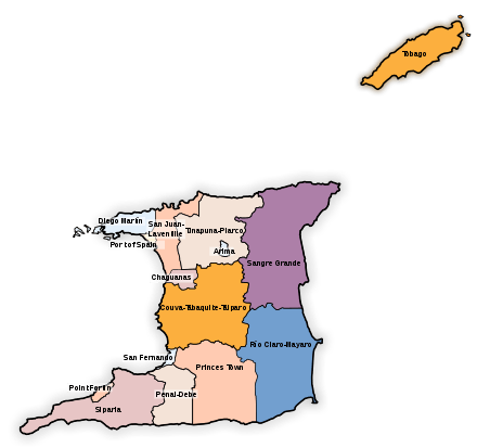
Trinidad
| Municipalities of Trinidad | |||||
|---|---|---|---|---|---|
| Municipality | Land area[1] | Population (2011)[2] |
Population density[1] | ||
| km² | sq mi | /km² | /sq mi | ||
| Port of Spain | 12 | 4.6 | 37,074 | 3,090 | 8,000 |
| San Fernando | 19 | 7.3 | 48,838 | 2,570 | 6,700 |
| Chaguanas | 59 | 23 | 83,516 | 1,416 | 3,670 |
| Arima | 12 | 4.6 | 33,606 | 2,801 | 7,250 |
| Point Fortin | 25 | 9.7 | 20,235 | 809 | 2,100 |
| Regions of Trinidad | ||||||
|---|---|---|---|---|---|---|
| Region | Land area[1] | Population (2011)[3] |
Population density[1] | Regional Capital | ||
| km² | sq mi | /km² | /sq mi | |||
| Couva–Tabaquite–Talparo | 723 | 279 | 178,410 | 247 | 640 | Couva |
| Diego Martin | 126 | 49 | 102,957 | 817 | 2,120 | Diego Martin |
| Mayaro–Rio Claro | 814 | 314 | 35,650 | 44 | 110 | Mayaro |
| Penal–Debe | 246 | 95 | 89,392 | 363 | 940 | Penal |
| Princes Town | 620 | 240 | 102,375 | 165 | 430 | Princes Town |
| San Juan–Laventille | 239 | 92 | 157,258 | 658 | 1,700 | San Juan |
| Sangre Grande | 927 | 358 | 75,766 | 82 | 210 | Sangre Grande |
| Siparia | 495 | 191 | 86,949 | 176 | 460 | Siparia |
| Tunapuna–Piarco | 510 | 200 | 215,119 | 422 | 1,090 | Tunapuna |
Before 1991 Trinidad was divided into eight counties.
Tobago
Tobago is a ward of Trinidad and Tobago and is governed locally by the Tobago House of Assembly.
Historically, Tobago was divided into seven parishes (Saint Andrew, Saint David, Saint George, Saint John, Saint Mary, Saint Patrick and Saint Paul). In 1768 each parish of Tobago had nominated representatives to the Tobago House of Assembly. On 20 October 1889 the British crown implemented a Royal Order in Council constituting Tobago as a ward of Trinidad, thus terminating local government on Tobago and formed a unified colony government.
In 1945 when the county council system was first introduced, Tobago was administered as a single county of Trinidad.
In 1980 provisions were made for the Tobago House of Assembly to be revived as an entity providing local government in Tobago. Under the revived system, Tobago is made up of 12 local electoral districts with each district electing one Assemblyman to the THA.
| No. | Electoral districts[4] |
|---|---|
| 1 | Bacolet / Mount St. George |
| 2 | Goodwood /Belle Garden west |
| 3 | Bethel / Mt. Irvine |
| 4 | Black Rock / Whim / Spring Garden |
| 5 | Buccoo / Mount Pleasant |
| 6 | Canaan / Bon Accord |
| 7 | Lambeau / Signal Hill |
| 8 | Parlatuvier / L’Anse Fourmi / Speyside |
| 9 | Plymouth / Golden Lane |
| 10 | Providence / Mason Hall / Moriah |
| 11 | Belle Garden East/ Roxborough / Delaford |
| 12 | Scarborough / Calder Hall |
See also
- ISO 3166-2:TT
- List of Caribbean First-level Subdivisions by Total Area
- Commonwealth Local Government Forum-Americas
Notes
- Trinidad and Tobago 2011 Population and Housing Census Demographic Report (PDF) (Report). Trinidad and Tobago Central Statistical Office. p. 26. Retrieved 27 May 2016.
- Trinidad and Tobago 2011 Population and Housing Census Demographic Report (PDF) (Report). Trinidad and Tobago Central Statistical Office. p. 5. Retrieved 27 May 2016.
- Trinidad and Tobago 2011 Population and Housing Census Demographic Report (PDF) (Report). Trinidad and Tobago Central Statistical Office. p. 5. Retrieved 27 May 2016.
- Electoral Districts in the Electoral Area of Tobago in relation to Tobago House of Assembly Elections, Elections & Boundaries Commission of T&T
References
- 2000 Census: Total Population by Sex, Sex Ratio and Area 2000
- Min. of Public Administration; Gov't. Information Service (2009). "Local Government in Trinidad and Tobago". NALIS. Archived from the original on 2010-06-12. Retrieved 26 Juiy 2010. Check date values in:
|accessdate=(help) - Dupont, Jerry (2001). "Trinidad and Tobago". The common law abroad: constitutional and legal legacy of the British empire. William S. Hein Publishing. pp. 295–303. ISBN 0-8377-3125-9. Retrieved 26 July 2010.
- Julien, Joel. "T&T goes to the polls again". Trinidad and Tobago Express. Archived from the original on 30 July 2010.
External links
Administrative divisions of the Americas | ||
|---|---|---|
| ||
| Sovereign states |
| .svg.png) |
| ||
Local Government in Trinidad and Tobago | ||
|---|---|---|
| Regional corporations |  | |
| Borough and city corporations | ||
| Other bodies | ||
| Counties (historic) | ||
| History | |||||
|---|---|---|---|---|---|
| Geography | |||||
| Politics | |||||
| Economy |
| ||||
| Society |
| ||||