Refugio Creek
Refugio Creek (pronounced REH-foo-GEE-oh from Spanish refugio meaning: shelter) is a 4.4-mile-long (7.1 km)[2] watercourse running through the Refugio Valley from the hills of western Contra Costa County, California.
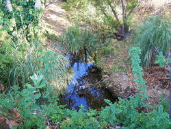
Refugio Creek by Creekside Center in Hercules, California
| Refugio Creek | |
|---|---|
| |
| Location | |
| Country | United States |
| State | California |
| Region | Contra Costa County |
| City | Rodeo, California |
| Physical characteristics | |
| Source | |
| ⁃ location | 4 mi (6 km) south of Crockett, California |
| ⁃ coordinates | 37°59′48″N 122°13′27″W[1] |
| ⁃ elevation | 660 ft (200 m) |
| Mouth | San Pablo Bay |
⁃ location | southwest of Rodeo, California |
⁃ coordinates | 38°1′18″N 122°17′7″W[1] |
⁃ elevation | 3 ft (0.91 m)[1] |
History
It runs from the hills to its mouth at San Pablo Bay through the city of Hercules and unincorporated areas, including the town of Rodeo. The creek passes through a dense suburban area in addition to Refugio Valley Park. The creek is almost entirely at the surface level and unaltered although its riparian habitat is largely destroyed in the more developed areas. Refugio means "refuge" in the Spanish language.
References
- U.S. Geological Survey Geographic Names Information System: Refugio Creek
- U.S. Geological Survey. National Hydrography Dataset high-resolution flowline data. The National Map, accessed March 15, 2011
External links
See also

This article is issued from Wikipedia. The text is licensed under Creative Commons - Attribution - Sharealike. Additional terms may apply for the media files.