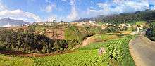
Quetzaltenango
Quetzaltenango (Spanish pronunciation: [ketsalteˈnaŋɡo], also known by its Maya name, Xelajú [ʃelaˈχu] or Xela [ˈʃela]), is both the capital of Quetzaltenango Department and the municipal seat of Quetzaltenango municipality.
Quetzaltenango Xelajú | |
|---|---|
Municipality and city | |
 Flag  Seal | |
 Quetzaltenango Location in Guatemala | |
| Coordinates: 14°50′40″N 91°30′05″W | |
| Country | |
| Department | |
| Foundation | May 7, 1524 |
| Government | |
| • Type | Municipality |
| • Mayor | Luis Grijalva Minera, Encuentro por Guatemala |
| Area | |
| • Municipality and city | 122 km2 (47 sq mi) |
| Elevation | 2,330 m (7,640 ft) |
| Population (2018 census)[1] | |
| • Municipality and city | 180,706 |
| • Density | 1,500/km2 (3,800/sq mi) |
| • Urban | 180,706 |
| Demonym(s) | Quetzalteca/o |
| Time zone | UTC-6 (Central America) |
| Climate | Oceanic climate: subtropical highland variety (Cwb) |
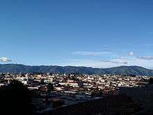
Quetzaltenango has a population of 180,706 (2018 census). The population is about 61% indigenous or Amerindian, 34% Mestizo or ladino and 5% white Latin American. The city is located in a mountain valley at an elevation of 2,330 meters (7,640 feet) above sea level at its lowest part. It may reach above 2,400 meters within the city.
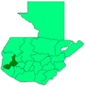
The Municipality of Quetzaltenango consists of an area of 122 km2. Municipalities abutting the municipality of Quetzaltenango include Salcajá, Cantel, Almolonga, Zunil, El Palmar, Concepción Chiquirichapa, San Mateo, La Esperanza, and Olintepeque in Quetzaltenango department and San Andrés Xecul in Totonicapán department.
History
In Pre-Columbian times Quetzaltenango was a city of the Mam Maya people called Xelajú, although by the time of the Spanish Conquest it had become part of the K'iche' Kingdom of Q'umarkaj. The name may be derived from xe laju' noj meaning "under ten mountains". The city was said to have already been over 300 years old when the Spanish first arrived. With the help of his allies, Conquistador Pedro de Alvarado defeated and killed the Maya ruler Tecún Umán here. When Alvarado conquered the city for Spain in the 1520s, he called it by the Nahuatl name used by his Central Mexican Indian allies, "Quetzaltenango", generally considered to mean "the place of the quetzal bird." Quetzaltenango became the city's official name in colonial times. However, many people (especially the indigenous population) continue to call the city "Xelajú" or more commonly "Xela" for short, and some proudly, but unofficially, consider it the "capital of the Mayas".
From 1838 to 1840 Quetzaltenango was capital of the state of Los Altos, one of the states or provinces of the Federal Republic of Central America. As the union broke up, the army of Guatemala under Rafael Carrera conquered Quetzaltenango making it again part of Guatemala. In 1850, the city had a population of approximately 20,000.[3]
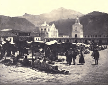
During the 19th century, coffee was introduced as a major crop in the area. As a result, the economy of Xela prospered. Much fine Belle Époque architecture can still be found in the city.
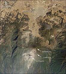
On October 24, 1902, at 5:00 pm, the Santa María Volcano erupted. Rocks and ash fell on Quetzaltenango at 6:00 pm, only one hour after the eruption.
In the 1920s, a young Gypsy woman named Vanushka Cardena Barajas died and was buried in the Xela city cemetery. An active legend has developed around her tomb that says those who bring flowers or write a request on her tomb will be reunited with their former romantic partners. The Guatemalan songwriter Alvaro Aguilar wrote a song based on this legend.
In 1930 the only electric railway in Guatemala, the Ferrocarril de Los Altos, was inaugurated. It was built by AEG and Krupp, and had 14 train cars. The track connected Quetzaltenango with San Felipe, Retalhuleu. It was soon destroyed by mudslides and finally demolished in 1933. The people of Quetzaltenango are still very proud of the railway. A railway museum has been established in the city centre.
Since the late 1990s Quetzaltenango has been having an economic boom, which makes it the city with the second-highest contribution to Guatemalan economy. With its first high-rise buildings being built, it is expected by 2015 to have a more prominent skyline, with buildings up to 15 floors tall.
In 2008, the Central American Congress PARLACEN stated that every September 15, Quetzaltenango will be Central America's capital of culture.[4]
Quetzaltenango was supposed to host the 2018 Central American and Caribbean Games, but dropped out due to lack of funding for the event.[5]
Climate
According to Köppen climate classification, Quetzaltenango features a subtropical highland climate (Cwb). In general, the climate in Quetzaltenango can go from mild to chilly, with occasional sporadic warm episodes. The daily high is usually reached around noon. From then on, temperatures decrease exceptionally fast. The city is quite dry, except during the rainy season. Quetzaltenango is the chilliest major city in Guatemala.
There are two main seasons in Quetzaltenango (as in all of Guatemala); the rainy season, which generally runs from late May through late October, and the dry season, which runs from early November until April. During the rainy season, rain falls consistently, usually in the afternoons, but there are occasions in which it rains all day long or at least during the morning. During the dry season, the city frequently will not receive a single drop of rain for months on end.
Coldest months are November through February, with minimum temperatures averaging 4 °C, and Maximum temperatures averaging 22 °C.
Warmest months are March through July, with minimum temperatures averaging 8 °C and Maximum temperatures averaging 23 °C.
Yearly, average low is 6 °C, and average high is 22 °C.
Below, is a chart for better comprehension.
| Climate data for Quetzaltenango - Labor Ovalle Weather Station (Temp.: 1991−2010 / Prec.: 1980−2010 | |||||||||||||
|---|---|---|---|---|---|---|---|---|---|---|---|---|---|
| Month | Jan | Feb | Mar | Apr | May | Jun | Jul | Aug | Sep | Oct | Nov | Dec | Year |
| Record high °C (°F) | 28.4 (83.1) |
29.8 (85.6) |
29.8 (85.6) |
28.2 (82.8) |
29.4 (84.9) |
26.5 (79.7) |
25.2 (77.4) |
25.0 (77.0) |
26.0 (78.8) |
25.2 (77.4) |
25.6 (78.1) |
26.2 (79.2) |
29.8 (85.6) |
| Average high °C (°F) | 22.0 (71.6) |
23.5 (74.3) |
25.5 (77.9) |
23.8 (74.8) |
23.1 (73.6) |
21.9 (71.4) |
21.9 (71.4) |
22.1 (71.8) |
20.9 (69.6) |
21.7 (71.1) |
21.3 (70.3) |
22.1 (71.8) |
22.5 (72.5) |
| Daily mean °C (°F) | 12.9 (55.2) |
13.7 (56.7) |
14.8 (58.6) |
15.8 (60.4) |
15.8 (60.4) |
15.6 (60.1) |
15.8 (60.4) |
15.8 (60.4) |
15.2 (59.4) |
15.0 (59.0) |
14.0 (57.2) |
13.2 (55.8) |
14.7 (58.5) |
| Average low °C (°F) | 2.3 (36.1) |
2.9 (37.2) |
3.9 (39.0) |
6.3 (43.3) |
8.8 (47.8) |
9.3 (48.7) |
8.2 (46.8) |
8.5 (47.3) |
9.0 (48.2) |
8.4 (47.1) |
6.0 (42.8) |
2.8 (37.0) |
6.4 (43.4) |
| Record low °C (°F) | −11.5 (11.3) |
−5.4 (22.3) |
−5.2 (22.6) |
−3.6 (25.5) |
0.6 (33.1) |
1.0 (33.8) |
2.5 (36.5) |
0.5 (32.9) |
1.0 (33.8) |
0.0 (32.0) |
−5.5 (22.1) |
−5.4 (22.3) |
−11.5 (11.3) |
| Average rainfall mm (inches) | 1.8 (0.07) |
5.5 (0.22) |
14.4 (0.57) |
41.2 (1.62) |
131.6 (5.18) |
147.8 (5.82) |
98.7 (3.89) |
107.0 (4.21) |
134.7 (5.30) |
93.6 (3.69) |
18.7 (0.74) |
7.1 (0.28) |
802.1 (31.59) |
| Average rainy days (≥ 0.1 mm) | 0.8 | 0.9 | 2.3 | 5.9 | 16.8 | 21.9 | 18.0 | 17.5 | 22.8 | 14.5 | 5.7 | 2.1 | 129.2 |
| Average relative humidity (%) | 65.7 | 63.1 | 64.5 | 68.4 | 74.5 | 79.4 | 74.5 | 76.1 | 81.2 | 79.3 | 72.7 | 68.6 | 72.3 |
| Mean monthly sunshine hours | 249.6 | 240.3 | 249.3 | 212.8 | 167.1 | 142.3 | 185.3 | 187.5 | 135.6 | 156.9 | 199.2 | 228.7 | 2,354.6 |
| Source: Instituto Nacional de Sismologia, Vulcanologia, Meteorologia, e Hidrologia[6] | |||||||||||||
Economy
Historically, the city produced wheat, maize, fruits, and vegetables. It also had a healthy livestock industry. Livestock was exported throughout the country and to El Salvador. As of 1850, wheat was the largest export, followed by cacao, sugar, wool and cotton.[3]
Sports
Quetzaltenango is home to the Club Xelajú MC soccer team. The team competes at Estadio Mario Camposeco which has a capacity of 13,500 and is the most successful non-capital team in the Liga Nacional de Fútbol de Guatemala.[7] It is also home to a rugby team in the newly formed Guatemalan rugby union and has enjoyed moderate success in the competition.
Due to the city's high altitude many athletes have prepared themselves here such as Olympic silver medalist Erick Barrondo and the 2004 Cuban volleyball team.
The swimming team has enjoyed success in national and international events.
Quetzaltenango withdrew from hosting the 2018 Central American and Caribbean Games. It planned to build a 30,000 seat stadium by 2016, as well seven new facilities for indoor sports and aquatics.[8]
Transportation

The city has a system of micro-buses for quick and cheap movement. A micro-bus is essentially a large van stuffed with seats. Micro-buses are numbered based on the route they take (e.g., "ruta 7"). There is no government-run mass transport system in the city. The sole public means of transport is the bus or micro-buses. Transportation to other cities is provided by bus. Bicycling is a way to get around and to travel to (and in) rural areas. Quetzaltenango Airport provides air service to the city.
Education
The Inter-American School is an American school for the children of Christian missionaries.
People born in Quetzaltenango
- Maria Vicenta Rosal (1820–1886), religious leader
- Manuel Barillas (1845–1907), President of Guatemala
- Rodolfo Robles (1878–1939), physician and philanthropist
- Manuel Estrada Cabrera (1898–1924), President of Guatemala
- Rodolfo Galeotti Torres (1912–1988), sculptor
- Efraín Recinos (1928–2011), engineer, architect, sculptor
- Jacobo Árbenz Guzmán (1913–1971), President of Guatemala
- Alberto Fuentes Mohr (1927–1979), economist, finance minister, foreign minister, social-democratic leaders
- Comandante Rolando Morán (1929-1998), one of the guerrilla leaders in the Guatemalan Civil War
- Carlos Navarrete Cáceres (b. 1931), anthropologist and writer
- Otto René Castillo (b. 1934), poet and revolutionary
- Juan Arturo Gutierrez, founder of international fast-food chain Pollo Campero
- Luis Rolando Ixquiac Xicara (b. 1947), artist
- Julio Serrano Echeverría (b. 1983), poet and writer[9]
Consular representations
International relations
Twin towns – Sister cities
Quetzaltenango is twinned with:


See also
- Luna de Xelajú
- 2018 Central American and Caribbean Games
- Club Xelajú MC, pro football team
- History of Guatemala
- History of Central America
- Tromsø, Norway, Quetzaltenango's twin city
- Livermore, California, also Quetzaltenango's twin city
References
- Citypopulation.de Population of departments and municipalities in Guatemala
- Citypopulation.de Population of the major cities in Guatemala
- Baily, John (1850). Central America; Describing Each of the States of Guatemala, Honduras, Salvador, Nicaragua, and Costa Rica. London: Trelawney Saunders. pp. 84–85.
- "GuateLog - Historia de Quetzaltenango". Archived from the original on 2012-04-26. Retrieved 2011-12-31.
- notisistema.com; Ciudad guatemalteca, candidata para Juegos Centroamericanos y del Caribe 2018.
- "Ministerio de comunicaciones Infraestructura y Vivienda". August 2011. Archived from the original on 2012-03-21. Retrieved 2011-08-04.
- mixelajumc.com
- noticias.emisorasunidas.com Archived 2012-03-23 at the Wayback Machine; Xela presenta candidatura para realizar Juegos Centroamericanos y del Caribe 2018. Radio Emisoras Unidas - en línea desde Guatemala.
- "Julio Serrano". www.literaturaguatemalteca.org. Retrieved 2020-01-05.
- https://web.archive.org/web/20071108234043/http://www.comunidades.gob.sv/comunidades/comunidades.nsf/pages/CenANoti9-06-181203
- http://www.embajada-consulado.com/consulados-de-italia_en_guatemala.html
- http://www.sre.gob.mx/quetzaltenango
- https://web.archive.org/web/20080617110652/http://www.lexureditorial.com/boe/0710/18083.htm
- Pessotto, Lorenzo. "International Affairs - Twinnings and Agreements". International Affairs Service in cooperation with Servizio Telematico Pubblico. City of Torino. Archived from the original on 2013-06-18. Retrieved 2013-08-06.
External links
| Wikimedia Commons has media related to Quetzaltenango, Quetzaltenango. |
| Wikivoyage has a travel guide for Quetzaltenango. |
- . Encyclopædia Britannica. 22 (11th ed.). 1911. p. 747.
| Authority control |
|
|---|