Cantel, Guatemala
Cantel is a municipality in the Quetzaltenango Department in Guatemala. It is located east of the city of Quetzaltenango and has an area of 52.6 km2. The town of Cantel, with a population of 35,825 (2018 census),[2] is situated at an altitude of 2,370 metres.
Cantel | |
|---|---|
Municipality and town | |
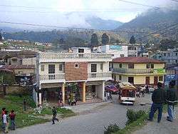 Cantel from the Quetzaltenango - Retalhueu highway | |
 Flag | |
 Cantel | |
| Coordinates: 14°48′40.4″N 91°27′19.84″W | |
| Country | |
| Department | |
| Area | |
| • Total | 20.3 sq mi (52.6 km2) |
| Population (2018 census)[1] | |
| • Total | 42,142 |
| • Density | 2,100/sq mi (800/km2) |
| Time zone | UTC+6 (Central Time) |
| Climate | Cwb |
Cantel includes the small Maya archaeological sites of Chojolom and Cerro Quiac.
References
- Citypopulation.de Population of departments and municipalities in Guatemala
- Citypopulation.de Population of cities & towns in Guatemala
External links
| Wikimedia Commons has media related to Cantel. |
| Wikivoyage has a travel guide for Cantel. |
This article is issued from Wikipedia. The text is licensed under Creative Commons - Attribution - Sharealike. Additional terms may apply for the media files.