Pulau Kanobe
Pulau Kanobe is a small Indonesian island located in the Ayu Archipelago above the northern tip of the Waigeo Islands.
Pulau Kanobe | |
|---|---|
 Pulau Kanobe Location of Pulau Kanobe in Indonesian Papua | |
| Coordinates: 0°30′1″N 131°7′26″E | |
| Country | |
| Province | |
| Time zone | UTC+09:00 (Eastern Indonesian Time) |
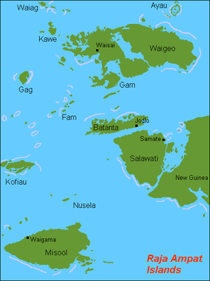 Location of Pulau Kanobe listed as Ayau (Ayu Islands) in the Raja Ampat Islands located in the top right corner of the map | |
| Geography | |
|---|---|
| Location | South East Asia |
| Coordinates | 0°22′N 131°02′E |
| Archipelago | Ayu Islands |
| Total islands | 5 (two uninhabited) |
| Major islands | Pulau Ayu, Pulau Reni, Pulau Kanobe |
| Administration | |
| Province | |
| Demographics | |
| Ethnic groups | Melanesians, Papuans, Austronesians |
Pulau Reni is part of the Raja Ampat regency of the West Papua geographical and administrative region of Indonesia.
Pulau Ayu and Pulau Reni are two other small inhabited islands near Pulau Kanobe.
Access to the island is limited to small boats due to the reefs and the small size of the island.
World War II
Pulau Reni and all the islands in the Ayu Archipelago were occupied by the Japanese Empire during World War II from 1942 until the end of the war in 1945.
External links
Administrative Region: West Papua | ||
| Islands | ||
Regencies and cities of West Papua | ||
|---|---|---|
Capital: Manokwari | ||
| Regencies | ||
| Cities | ||
This article is issued from Wikipedia. The text is licensed under Creative Commons - Attribution - Sharealike. Additional terms may apply for the media files.