Pointe-à-Pitre
Pointe-à-Pitre (French: Pointe-à-Pitre, pronounced [pwɛ̃tapitʁ]; Creole: Lapwent, [lapwɛ̃t]) is the largest city of Guadeloupe, an overseas région and département of France located in the Lesser Antilles, of which it is a sous-préfecture, being the seat of the Arrondissement of Pointe-à-Pitre.
Pointe-à-Pitre | |
|---|---|
Subprefecture and commune | |
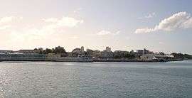 A view of Pointe-à-Pitre, from the seaport | |
 Coat of arms | |
 Location of the commune (in red) within Guadeloupe | |
Location of Pointe-à-Pitre 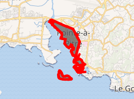
| |
| Coordinates: 16°14′28″N 61°31′59″W | |
| Country | France |
| Overseas region and department | Guadeloupe |
| Arrondissement | Pointe-à-Pitre |
| Canton | Pointe-à-Pitre |
| Government | |
| • Mayor (2008–2014) | Jacques Bangou[1] |
| Area 1 | 2.66 km2 (1.03 sq mi) |
| Population (2013) | 15,992 |
| • Density | 6,000/km2 (16,000/sq mi) |
| • Metro (2014) | 314,647[2] |
| Time zone | UTC−04:00 (AST) |
| INSEE/Postal code | 97120 /97110 |
| 1 French Land Register data, which excludes lakes, ponds, glaciers > 1 km2 (0.386 sq mi or 247 acres) and river estuaries. | |
Although Pointe-à-Pitre is not Guadeloupe's administrative capital (that distinction goes to Basse-Terre), it is nonetheless the region's largest city and economic capital. In 1999, it had a population of 171,773 inhabitants in its urban area, of whom 17,541 lived in the city (commune) of Pointe-à-Pitre proper. The inhabitants are called "Pointois". In 2014, its metropolitan population was estimated at 314,647 people.
Pointe-à-Pitre International Airport, Guadeloupe's main international airport, is located 3 km (1.9 mi) north of downtown Pointe-à-Pitre in the commune of Les Abymes.
Jacques Bangou is the current mayor of Pointe-à-Pitre.[3]
Geography
Pointe-à-Pitre is situated on the southwest portion of the island of Grande-Terre, facing the Caribbean Sea; it lies in the centre of Guadeloupe, and is near the Rivière Salée ("Salt River"), which separates Grande-Terre from Basse-Terre Island. The town of Pointe-à-Pitre is surrounded by the communes of Les Abymes, Baie-Mahault and Le Gosier. Pointe-à-Pitre is on a limestone plateau, which was a factor for the construction of the city. The bay, Petit Cul-de-Sac Marin, offers a sheltered port.
Name[4]
The name Pointe-à-Pitre, literally the "headland of Pitre", is often said to derive from a Dutch Jewish sailor/fisherman called "Pieter", who settled in the 17th century on a promontory facing the Îlet à Cochon ("Hogs Islet"), just to the south of today's downtown Pointe-à-Pitre. The promontory came to be called "Pointe-à-Pieter" (the "headland of Peter") and later "Pointe-à-Pitre".
History
French colonial authorities had long thought about establishing a city on the current location of Pointe-à-Pitre, at the junction of Guadeloupe's two main 'island' districts (Basse-Terre Island and Grande Terre), but several attempts around 1713-1730 failed due to the insalubrious swampy ground.
During the British occupation of Guadeloupe (1759–1763) a settlement appeared on a hill overlooking the swamps. After the return of Guadeloupe to France in 1763, the city of Pointe-à-Pitre was officially founded under governor Gabriel de Clieu in 1764 by royal edict, and the swamps where downtown Pointe-à-Pitre stands today were drained in the following years, thus allowing the urban development of the city.
The development of the city was relatively rapid, partly thanks to the corsairs. In 1780, however, a great fire entirely destroyed the city. Sixty-three years later, in 1843, it was again destroyed by an earthquake. The history of Pointe-à-Pitre is marked by many disasters: the fires of 1850, 1871 and 1931, the earthquakes of 1851 and 1897 and the hurricanes of 1865 and 1928. The city also experienced several epidemics of cholera. Its location and large sheltered port have nonetheless allowed Pointe-à-Pitre to become Guadeloupe's largest city and economic capital.
Religion
The former cathedral of St. Peter and Paul, Ancienne cathédrale Saint-Pierre-et-Saint-Paul, testifies that Pointe-à-Pitre has been the episcopal seat of a Roman Catholic Diocese of Pointe-à-Pitre on Grande-Terre. This was united with the present diocese for all Guadeloupe, at Basse-Terre, in 1951, since when its full title has been Roman Catholic Diocese of Basse-Terre-Pointe-à-Pitre.
Climate
On the Köppen climate classification, Pointe-à-Pitre is on the border between tropical monsoon climate (Am) and tropical rainforest climate (Af). Like any other Eastern Caribbean city, it experiences rainfall quite evenly spread during the year, with a wetter season between July and November which coincides with the hurricane season. The city receives 1500–2000 mm of rainfall annually. Tropical heat is the norm, bringing steady highs of around 32 °C (89 °F) that drop to 20 °C (68 °F) at night.
| Climate data for Abymes adjacent to Pointe-à-Pitre (Le Raizet Airport) 1981–2010 averages, extremes 1950–present | |||||||||||||
|---|---|---|---|---|---|---|---|---|---|---|---|---|---|
| Month | Jan | Feb | Mar | Apr | May | Jun | Jul | Aug | Sep | Oct | Nov | Dec | Year |
| Record high °C (°F) | 31.8 (89.2) |
32.1 (89.8) |
32.8 (91.0) |
33.3 (91.9) |
33.3 (91.9) |
33.4 (92.1) |
34.2 (93.6) |
34.2 (93.6) |
34.1 (93.4) |
34.1 (93.4) |
33.4 (92.1) |
32.4 (90.3) |
34.2 (93.6) |
| Average high °C (°F) | 29.2 (84.6) |
29.2 (84.6) |
29.7 (85.5) |
30.3 (86.5) |
30.9 (87.6) |
31.4 (88.5) |
31.6 (88.9) |
31.9 (89.4) |
31.7 (89.1) |
31.3 (88.3) |
30.5 (86.9) |
29.7 (85.5) |
30.6 (87.1) |
| Daily mean °C (°F) | 24.9 (76.8) |
24.9 (76.8) |
25.3 (77.5) |
26.3 (79.3) |
27.2 (81.0) |
27.9 (82.2) |
28.0 (82.4) |
28.0 (82.4) |
27.8 (82.0) |
27.3 (81.1) |
26.5 (79.7) |
25.5 (77.9) |
26.6 (79.9) |
| Average low °C (°F) | 20.7 (69.3) |
20.6 (69.1) |
21.0 (69.8) |
22.2 (72.0) |
23.6 (74.5) |
24.3 (75.7) |
24.3 (75.7) |
24.1 (75.4) |
23.8 (74.8) |
23.3 (73.9) |
22.4 (72.3) |
21.3 (70.3) |
22.6 (72.7) |
| Record low °C (°F) | 13.5 (56.3) |
13.0 (55.4) |
13.9 (57.0) |
15.8 (60.4) |
16.4 (61.5) |
18.9 (66.0) |
19.6 (67.3) |
19.8 (67.6) |
19.5 (67.1) |
19.0 (66.2) |
16.8 (62.2) |
14.4 (57.9) |
13.0 (55.4) |
| Average precipitation mm (inches) | 83.0 (3.27) |
60.0 (2.36) |
67.9 (2.67) |
96.5 (3.80) |
134.1 (5.28) |
107.8 (4.24) |
129.6 (5.10) |
169.1 (6.66) |
206.2 (8.12) |
214.5 (8.44) |
213.9 (8.42) |
134.0 (5.28) |
1,616.6 (63.65) |
| Average precipitation days (≥ 1.0 mm) | 15.83 | 12.30 | 11.10 | 10.73 | 13.07 | 13.20 | 15.20 | 16.43 | 16.27 | 17.50 | 17.40 | 16.47 | 175.50 |
| Mean monthly sunshine hours | 192.4 | 182.7 | 217.5 | 211.4 | 212.7 | 206.5 | 198.3 | 221.5 | 200.6 | 181.7 | 181.4 | 189.1 | 2,395.7 |
| Source: Meteo France[5][6][7] | |||||||||||||
The trade winds blow from the northeast and often temper the climate.
Urban area and demographics
The tiny commune (municipality) of Pointe-à-Pitre is the center of a larger urban area covering several communes. This urban area – with 171,773 inhabitants at the 1999 census, representing 40% of the population – is the largest in Guadeloupe and one of the largest among French Overseas territories and departments.
Communes
The seven communes making up the urban area of Pointe-à-Pitre, with their 1999 populations, are:
- Les Abymes: 63,054 (Les Abymes being the most populated commune in the urban area and indeed in Guadeloupe, the urban area of Pointe-à-Pitre is also often called the "Pointe-à-Pitre-Les Abymes" urban area)
- Le Gosier: 25,360
- Baie-Mahault: 23,389 (the location of the urban area's main seaport and largest industrial park in the Lesser Antilles)
- Pointe-à-Pitre: 20,948 (the historic, commercial and administrative heart of the urban area; facing competition from its suburbs, the congested commune of Pointe-à-Pitre has been losing businesses and inhabitants in the past years)
- Petit-Bourg: 20,528
- Lamentin: 13,434
- Goyave: 5,060
Economy
The city is the commercial capital of Guadeloupe, serving as the main port of call for cargo and passengers alike. The main seaport is the Port de Jarry located across the Bay of Cul-de-Sac Marin in the commune (municipality) of Baie-Mahault. It has one of the biggest container terminals in the Eastern Caribbean with a quay 600m[8] long. The main exports are food crops (bananas, cocoa, coffee and sugar), animal products (beef, milk, yogurt) and manufactured goods (refined petroleum, textiles and medicines). The extensive Zone Industrielle de Jarry, directly west of Pointe-à-Pitre is a major centre of commercial and light industrial activity, notably for warehousing and distribution. Agricultural production continues in the east of the area where cattle rearing, banana and sugarcane growing continues. The nearby suburb of Le Gosier is Guadeloupe's main seaside resort.
Seventy percent of residents of Pointe-à-Pitre resided in subsidized public housing in 2009.[9]
People
- Maryse Condé - writer
- Saint-John Perse
- Francky Vincent
- Rodrigue Beaubois - NBA Dallas Mavericks player
- Roch-Ambroise Auguste Bébian
- Jean-Marc Mormeck, boxer
- Auguste Plée
- Firmine Richard
- Jacques Schwarz-Bart
- Louis-Gaston de Sonis - French Army officer
- Lilian Thuram - former Juventus and FC Barcelona association football player. Won 142 caps for France and the 1998 FIFA World Cup.
- Stéphane Zubar - AFC Bournemouth player
- Laura Flessel-Colovic - 5-time Olympic medalist in épée fencing
- Patricia Girard - 1996 Olympic Games silver medallist in 100m hurdles
- Thierry Henry
Education
Public preschools in Pointe-à-Pitre commune include:[10]
- Ecole maternelle Raymonde Bambuck
- Ecole maternelle Bébian
- Ecole maternelle Salvator Cidemé
- Ecole maternelle Dubouchage
- Ecole maternelle Bonchamps Fernande
- Ecole maternelle Rallion Frantz
- Ecole maternelle Raphael Jolivière 2
- Ecole maternelle Lauricisque
Public primary schools in Pointe-à-Pitre commune include:[10]
- Ecole primaire Raymonde Bambuck
- Ecole primaire Salvator Cidemé
- Ecole primaire Raphael Cipolin
- Ecole primaire Léon Feix
- Ecole primaire Amédée Fengarol 1
- Ecole primaire Amédée Fengarol 2
- Ecole primaire Bonchamps Fernande
- Ecole primaire Lauricisque
Elementary schools include:
- Ecole élémentaire Raphael Jolivière 1
Public junior high schools in Pointe-à-Pitre commune include:[11]
- Collège Jules Michelet
- Collège Sadi Carnot
- Collège Nestor De Kermadec
- Collège Front de mer
Public senior high schools in Pointe-à-Pitre commune include:[11]
- LPO Carnot (including the Micro Lycée)
Private preschools and primary schools in Pointe-à-Pitre commune include:[10]
- Ecole maternelle privée Notre-Dame du Sacré-Coeur
- Ecole primaire privée Saint Joseph de Clun
Private secondary schools under contract in Pointe-à-Pitre commune:[12]
- LP Boc Calmet
- Collège/LGT Massabielle
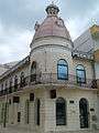
Monuments
- Place de la Victoire
- La rue Frébault, marché aux Épices (classé MH[13])
- The musée Saint-John-Perse (classé MH[14])
- The musée Schœlcher (classé MH[15])
- The Pavillon L'Herminier (classé MH[16])
- The Mémorial ACTe[17]
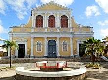
- The église Saint-Pierre-et-Saint-Paul (classée MH)[18]
- The church of Massabielle.
- Various elements of the civil and religious heritage of the municipality were built by the architect Ali Tur between 1930 and 1935 in a major works initiative by various institutions after the 1928 Okeechobee hurricane. He realized the palais de justice de Pointe-à-Pitre, the hospice hospital on the island, the fish hall, several schools, and the fire station.[19]
- The statues of La Mulâtresse Solitude, Colonel Louis Delgrès, Colonel Joseph Ignace, percussionist Marcel Lollia (popularly known as "Vélo") and the painting of Émeutes de mai 1967 en Guadeloupe
 Le marché aux Épices.
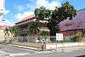 Musée Saint-John-Perse.
 Musée Schœlcher.
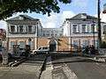
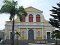 Église Saint-Pierre-et-Saint-Paul.
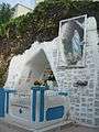 La grotte de Massabielle.
 Tourism office of Pointe-à-Pitre
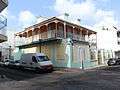 school of Pointe-à-Pitre
References
- "Archived copy". Archived from the original on 2008-11-13. Retrieved 2008-09-26.CS1 maint: archived copy as title (link)
- https://www.insee.fr/fr/statistiques/2874200?sommaire=2874226&geo=AU2010-9A1
- "Guadeloupe protesters shoot three police officers". AFP. Sydney Morning Herald. 2009-02-18. Retrieved 2009-02-19.
- L’origine toponyme de Pointe-à-Pitre Archived 2007-10-17 at the Wayback Machine in Guide de Pointe-à-Pitre (édition 2006-2007).
- "Données climatiques de la station de Le Raizet" (in French). Meteo France. Retrieved December 17, 2014.
- "Climat Guadeloupe". Meteo France. Retrieved December 17, 2014.
- "Le Raizet Aero (971)" (PDF). Fiche Climatologique: Statistiques 1981–2010 et records (in French). Meteo France. Archived from the original (PDF) on 29 March 2018. Retrieved 29 March 2018.
- Kalmar Industries
- Davies, Lizzy (2009-02-18). "Guadaloupe riots turn paradise into war zone as one protester shot dead". The Guardian. Retrieved 2009-02-19.
- "LISTE DES ECOLES PUBLIQUES ET PRIVEES SOUS CONTRAT." Académie de la Guadeloupe. Retrieved on 10 March 2018.
- "Établissements du 2nd degré PUBLIC 2017-2018." Académie de la Guadeloupe. Retrieved on 10 March 2018.
- "Etablissements du 2nd degré privé sous contrat 2017-2018."Académie de la Guadeloupe. Retrieved on 10 March 2018.
- Mérimée PA00105881, Ministère français de la Culture. (in French).
- Mérimée PA00105868, Ministère français de la Culture. (in French).
- Mérimée PA00105869, Ministère français de la Culture. (in French).
- Mérimée PA97100030, Ministère français de la Culture. (in French).
- Le Mémorial ACTe de Guadeloupe présenté à Paris.
- Mérimée PA00105864, Ministère français de la Culture. (in French).
- Robin-Clerc, Michèle (30 August 2010). Conseil régional de Guadeloupe (ed.). "Note descriptive de l'œuvre d'Ali Tur" (PDF) (in French). Basse-Terre. pp. 7–8. Retrieved 13 May 2017..
External links
| Wikimedia Commons has media related to Pointe-à-Pitre. |
| Authority control |
|
|---|