Saint-François, Guadeloupe
Saint-François is a commune of the Guadeloupe department, in the south-east point of the main island, Grande-Terre.
Saint-François | |
|---|---|
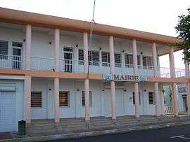 The town hall of Saint-François | |
 Location of the commune (in red) within Guadeloupe | |
Location of Saint-François 
| |
| Coordinates: 16°15′00″N 61°17′00″W | |
| Country | France |
| Overseas region and department | Guadeloupe |
| Arrondissement | Pointe-à-Pitre |
| Canton | Saint-François |
| Government | |
| • Mayor | Laurent Bernier |
| Area 1 | 61.00 km2 (23.55 sq mi) |
| Population (2013) | 14,965 |
| • Density | 250/km2 (640/sq mi) |
| Time zone | UTC−04:00 (AST) |
| INSEE/Postal code | 97125 /97118 |
| Elevation | 0–67 m (0–220 ft) |
| 1 French Land Register data, which excludes lakes, ponds, glaciers > 1 km2 (0.386 sq mi or 247 acres) and river estuaries. | |
Settlements include Chassaing, Dubedou, and Kahouanne: an uninhabited islet of 1,500 metres from the coast. It is about 0.541 km2 (0.209 sq mi) in area and is a protected site.[1]
There are four public preschools and eight public primary schools.[2]
The Collège Alexandre Macal is a public junior high school.[3]
La Pointe des Châteaux
La Pointe des Châteaux is a peninsula that extends into the Atlantic Ocean.
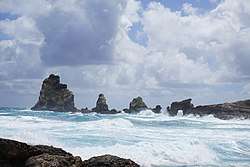
Eleven kilometres east of Saint-François, a large littoral strip, La Pointe des Châteaux hosts rare fauna and flora, some of which are indigenous to the site.
It attracts about 500,000 visitors per year. North-west of the Pointe des Châteaux's clifftop is beach les Grandes Salines.
References
- "ILET KAHOUANNE - Conservatoire du littoral". Retrieved 20 July 2016.
- "LISTE DES ECOLES PUBLIQUES ET PRIVEES SOUS CONTRAT." Académie de la Guadeloupe. Retrieved on 10 March 2018.
- "Établissements du 2nd degré PUBLIC 2017-2018." Académie de la Guadeloupe. Retrieved on 10 March 2018.
Gallery
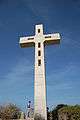 Cross at the very clifftop of the Pointe des Châteaux
 Cross at the Pointe des Châteaux and La Désirade out far
 A far view of La Désirade from the Pointe des Châteaux
 Pointe des Châteaux, Guadeloupe
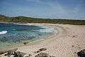 The long beach of "Grandes Salines" at Pointe des Châteaux
 The long beach of "Grandes Salines" at Pointe des Châteaux
External links
- Office de Tourisme de Saint François – Official site of the Saint-François Tourism Board
| Wikimedia Commons has media related to Saint-François (Guadeloupe). |
| Authority control |
|
|---|