Plummer Additional
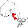
Plummer Additional is a township and single tier municipality[2] located in Algoma District in Northeastern Ontario, Canada. The township had a population of 660 in the Canada 2016 Census.
Plummer Additional | |
|---|---|
| Township of Plummer Additional | |
 Countryside at Plummer | |
 Plummer Additional | |
| Coordinates: 46°22′N 83°46′W | |
| Country | Canada |
| Province | Ontario |
| District | Algoma |
| Incorporated | 1891 |
| Government | |
| • Mayor | Beth West |
| • MP | Carol Hughes (NDP) |
| • MPP | Michael Mantha (NDP) |
| Area | |
| • Land | 220.30 km2 (85.06 sq mi) |
| Elevation | 242 m (794 ft) |
| Population (2016)[1] | |
| • Total | 660 |
| • Density | 3.0/km2 (8/sq mi) |
| Time zone | UTC-5 (EST) |
| • Summer (DST) | UTC-4 (EDT) |
| Postal Code | P0R 1C0 |
| Area code(s) | 705 and 249 (785 exchange) |
| Website | plummertownship.ca |

Communities
The township includes the communities of Bruce Station, Cloudslee, Plummer, Rock Lake and Rydal Bank.
The town of Bruce Mines is wholly surrounded by, but politically independent of, the township; it was separated in 1903. However, the 2010 mayoral election in Bruce Mines was won by Gordon Post, a candidate who pledged to investigate the feasibility of reamalgamating the two municipalities.[3]
History
Rydal Bank Church located at Rydal Bank within the township is a municipally designated heritage site.
Demographics
| Canada census – Plummer Additional community profile | |||
|---|---|---|---|
| 2016 | 2011 | 2006 | |
| Population: | 660 (1.5% from 2011) | 650 (4.0% from 2006) | 625 (-6.9% from 2001) |
| Land area: | 220.30 km2 (85.06 sq mi) | 221.97 km2 (85.70 sq mi) | 221.31 km2 (85.45 sq mi) |
| Population density: | 3.0/km2 (7.8/sq mi) | 2.9/km2 (7.5/sq mi) | 2.8/km2 (7.3/sq mi) |
| Median age: | 52.1 (M: 51.2, F: 54.0) | 49.4 (M: 49.6, F: 49.3) | |
| Total private dwellings: | 515 | 433 | 442 |
| Median household income: | $52,582 | ||
| References: 2016[4] 2011[5] 2006[6] earlier[7] | |||
Population trend:[8]
- Population in 2016: 660
- Population in 2011: 650
- Population in 2006: 625
- Population in 2001: 671
- Population in 1996: 693
- Population in 1991: 596
Transportation
The township is served by Ontario Highway 17 which traverses the south in an east–west orientation, and Ontario Highway 638, which travels the middle of the township in a north–south orientation.
See also
References
- "Plummer Additional census profile". 2016 Census of Population. Statistics Canada. Retrieved 2019-06-04.
- "List of Ontario Municipalities". Ontario Ministry of Municipal Affairs and Housing. 2011-01-06. Archived from the original on 2013-02-28. Retrieved 2011-02-26.
- Ougler, Jeffrey (October 26, 2010). "Post delivered to top Bruce Mines post; to probe Plummer union". Sault Star. Retrieved February 27, 2011.
- "2016 Community Profiles". 2016 Canadian Census. Statistics Canada. February 21, 2017. Retrieved 2019-06-04.
- "2011 Community Profiles". 2011 Canadian Census. Statistics Canada. July 5, 2013. Retrieved 2012-02-17.
- "2006 Community Profiles". 2006 Canadian Census. Statistics Canada. March 30, 2011. Retrieved 2011-04-14.
- "2001 Community Profiles". 2001 Canadian Census. Statistics Canada. February 17, 2012.
- Statistics Canada: 1996, 2001, 2006, 2011 census
- "Plummer Additional". Geographical Names Data Base. Natural Resources Canada. Retrieved 2011-02-24.
- "Plummer Additional". Atlas of Canada. Natural Resources Canada. 2010-02-04. Retrieved 2011-02-24.
External links
Places adjacent to Plummer Additional | ||||||||||
|---|---|---|---|---|---|---|---|---|---|---|
| ||||||||||