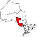
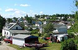
Hornepayne
Hornepayne is a township of 980 people (Canada 2016 Census) in the Algoma District of Ontario, Canada. The town was established in 1915 as Fitzback when the Canadian Northern Railway's transcontinental line was built through the area. It was renamed Hornepayne in 1920 after British financier Robert Horne-Payne.[2][3]
Hornepayne | |
|---|---|
| Township of Hornepayne | |
 | |
Logo of the Township of Hornepayne | |
 Hornepayne | |
| Coordinates: 49°13′N 84°47′W | |
| Country | Canada |
| Province | Ontario |
| District | Algoma |
| Established | 1915 |
| Incorporated | 1927 |
| Government | |
| • Type | Township |
| • Mayor | Cheryl T. Fort |
| • Federal riding | Algoma—Manitoulin—Kapuskasing |
| • Prov. riding | Algoma—Manitoulin |
| Area | |
| • Land | 204.52 km2 (78.97 sq mi) |
| Population (2016)[1] | |
| • Total | 980 |
| • Density | 4.8/km2 (12/sq mi) |
| Time zone | UTC-5 (EST) |
| • Summer (DST) | UTC-4 (EDT) |
| Postal Code | P0M |
| Area code(s) | 807 |
| Website | www.townshipofhornepayne.ca |
Demographics
| Canada census – Hornepayne community profile | |||
|---|---|---|---|
| 2016 | 2011 | 2006 | |
| Population: | 980 (-6.7% from 2011) | 1,050 (-13.2% from 2006) | 1,209 (-11.2% from 2001) |
| Land area: | 204.07 km2 (78.79 sq mi) | 204.52 km2 (78.97 sq mi) | 204.52 km2 (78.97 sq mi) |
| Population density: | 4.8/km2 (12/sq mi) | 5.1/km2 (13/sq mi) | 5.9/km2 (15/sq mi) |
| Median age: | 42.9 (M: 43.1, F: 42.4) | 41.2 (M: 41.0, F: 41.5) | 38.6 (M: 39.5, F: 38.1) |
| Total private dwellings: | 514 | 518 | 539 |
| Median household income: | $99,584 | $68,217 | |
| References: 2016[4] 2011[5] 2006[6] earlier[7] | |||
Population:[8]
- Population in 2011: 1,050
- Population in 2006: 1,209
- Population in 2001: 1,362
- Population in 1996: 1,480
- Population in 1991: 1,610
Mother tongue:[9]* English as first language: 78.3%
- French as first language: 16.3%
- English and French as first language: 0%
- Other as first language: 5.4%
Economy
Hornepayne serves as a railway divisional point on the main Canadian National Railway line. The forestry industry (by way of Haavaldsrud's Timber Company[10]) is the major employer to the local economy. Hunting- and fishing-related tourism in the area (particularly just north of the town in nearby Nagagami Lake Provincial Park) is served by several small companies.[11][12][13]
The township of Hornepayne has been the proposed site of a low level nuclear waste storage facility for some time. The town's community liaison group chose to withdraw from this development in the early 1990s,[14] but as of May 2010 the township is still being considered for nuclear waste management/storage.[15]
Geological history
Hornepayne is situated in the Horseshoe of Rock, which forms the Pre-Cambrian area, which surrounds Hudson Bay. It is the oldest rock in the world, containing the famous Keewatin Greenstone. Massive Granite intrusions, of which Tank Hill is a good example, is the predominate rock in the area
Greenstone can be found six miles north along highway 631 and in numerous bands along Government Lake Road. Volcanoes were numerous, and specimens of their eruptions in the soil today. The Pre-Cambrian was covered by at least three Ice Ages which, with glaciers miles high, bulldozed the mountains away just as a bulldozer today would level a small hill. The rock and earth were moved as far south as Wisconsin.
Evidence of glacial scratches can be found on Tank Hill. The sand hills near Cedar Point are eskers left by the Glaciers. Boulders, small rocks, and clay, are scattered throughout the area, part of the glacial wash. A typical volcanic core is to be found about five miles north. The highway runs through it. Samples of Volcanics, such as garnets, surpentine, and rhyolite, can be found. Most of the Pre-Cambrian is covered by a thin layer of organic soil and clay. Hornepayne is approximately eight miles north of the height of land. Drainage is poor in the area, which has many muskeg swamps.
Transportation
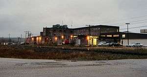
Hornepayne is served by the Canadian, Canada's transcontinental passenger rail service, which is operated by Via Rail and which stops at Hornepayne station. The town is also home to the Hornepayne Municipal Airport.
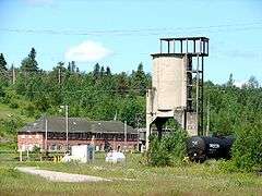 The CN rail yard; the old station in the background is no longer in use and fallen in disrepair. |
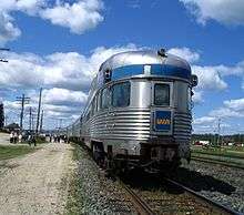 Passengers milling around the train at the station stop in Hornepayne. |
Popular culture
- Retired ice hockey player Mike McEwen was born in Hornepayne.
- Retired ice hockey player Goldie Goldthorpe (who served as the inspiration for Ogie Ogilthorpe in the 1977 film Slap Shot) was born in Hornepayne.
- Senior Vice President of Hockey Operations for NHL Kris King, was raised in Hornepayne.
- Gordon Lightfoot's song "On the High Seas" mentions Hornepayne with the following lyric "Was it up in Hornepayne, where the trains run on time?"
- Hornepayne was featured on an episode of Survivorman with Les Stroud and a slew of NHL hockey players.
Climate
Hornepayne experiences a subarctic climate, typical in Northern Ontario, with cold winters and generally warm summers. Winter usually begins around Halloween, lasting way into March, though wintry days can sometimes be experienced even later in the season. Snowfall is abundant, starting to fall usually sometime in October, and keeps falling into April, with snowfalls in May not uncommon.[16]
| Climate data for Hornepayne, Ontario (1971–2000) | |||||||||||||
|---|---|---|---|---|---|---|---|---|---|---|---|---|---|
| Month | Jan | Feb | Mar | Apr | May | Jun | Jul | Aug | Sep | Oct | Nov | Dec | Year |
| Record high °C (°F) | 6.7 (44.1) |
12.8 (55.0) |
18.9 (66.0) |
28.9 (84.0) |
33.0 (91.4) |
37.2 (99.0) |
37.2 (99.0) |
34.4 (93.9) |
31.7 (89.1) |
31.7 (89.1) |
18.0 (64.4) |
12.5 (54.5) |
37.2 (99.0) |
| Average high °C (°F) | −13.1 (8.4) |
−9.2 (15.4) |
−2.6 (27.3) |
6.9 (44.4) |
16.4 (61.5) |
21.0 (69.8) |
24.1 (75.4) |
22.0 (71.6) |
15.3 (59.5) |
8.6 (47.5) |
0.5 (32.9) |
−8.8 (16.2) |
6.8 (44.2) |
| Daily mean °C (°F) | −19.7 (−3.5) |
−16 (3) |
−9.2 (15.4) |
0.4 (32.7) |
8.9 (48.0) |
13.4 (56.1) |
16.4 (61.5) |
14.2 (57.6) |
8.8 (47.8) |
3.5 (38.3) |
−3.8 (25.2) |
−14.5 (5.9) |
0.2 (32.4) |
| Average low °C (°F) | −26.1 (−15.0) |
−22.7 (−8.9) |
−15.7 (3.7) |
−6.1 (21.0) |
1.5 (34.7) |
5.7 (42.3) |
8.6 (47.5) |
8.5 (47.3) |
2.2 (36.0) |
−1.6 (29.1) |
−8.1 (17.4) |
−20.3 (−4.5) |
−6.3 (20.7) |
| Record low °C (°F) | −49.4 (−56.9) |
−52.2 (−62.0) |
−43.9 (−47.0) |
−37.2 (−35.0) |
−15 (5) |
−12.2 (10.0) |
−9.4 (15.1) |
−7.2 (19.0) |
−12.2 (10.0) |
−27.2 (−17.0) |
−40 (−40) |
−52.2 (−62.0) |
−52.2 (−62.0) |
| Average precipitation mm (inches) | 53.4 (2.10) |
38.5 (1.52) |
38.9 (1.53) |
28.7 (1.13) |
51.4 (2.02) |
81.5 (3.21) |
65.4 (2.57) |
67.2 (2.65) |
70.3 (2.77) |
60.8 (2.39) |
49.3 (1.94) |
51.0 (2.01) |
656.4 (25.84) |
| Average rainfall mm (inches) | 0.1 (0.00) |
1.6 (0.06) |
3.9 (0.15) |
11.1 (0.44) |
45.3 (1.78) |
81.5 (3.21) |
65.4 (2.57) |
67.2 (2.65) |
69.4 (2.73) |
48.9 (1.93) |
15.1 (0.59) |
0.9 (0.04) |
410.5 (16.16) |
| Average snowfall cm (inches) | 53.3 (21.0) |
36.9 (14.5) |
35.0 (13.8) |
17.6 (6.9) |
6.1 (2.4) |
0.0 (0.0) |
0.0 (0.0) |
0.0 (0.0) |
0.9 (0.4) |
12.6 (5.0) |
34.3 (13.5) |
50.1 (19.7) |
246.7 (97.1) |
| Average precipitation days (≥ 0.2 mm) | 8.6 | 6.8 | 7.3 | 5.9 | 7.3 | 9.2 | 8.6 | 9.4 | 12.9 | 10.9 | 9.2 | 9.4 | 105.5 |
| Average rainy days (≥ 0.2 mm) | 0.12 | 0.38 | 1.1 | 2.8 | 6.5 | 9.2 | 8.6 | 9.4 | 12.8 | 8.6 | 2.6 | 0.41 | 62.5 |
| Average snowy days (≥ 0.2 cm) | 8.5 | 6.7 | 6.4 | 3.6 | 1.0 | 0.0 | 0.0 | 0.0 | 0.22 | 2.9 | 7.1 | 9.3 | 45.7 |
| Source: Environment Canada[17] | |||||||||||||
See also
- Hornepayne Municipal Airport
- Hornepayne Water Aerodrome
- Hornepayne railway station
- List of townships in Ontario
- List of francophone communities in Ontario
References
- "Hornepayne census profile". 2016 Census of Population. Statistics Canada. Retrieved 2018-04-13.
- Roy, Patricia. "Robert Montgomery Horne-Payne". The Canadian Encyclopedia. Retrieved 3 October 2016.
- Douglas, Daniel (1995). Northern Algoma : a people's history. Toronto: Dundurn Press. p. 87. ISBN 9781550022353.
- "2016 Community Profiles". 2016 Canadian Census. Statistics Canada. February 21, 2017. Retrieved 2017-04-13.
- "2011 Community Profiles". 2011 Canadian Census. Statistics Canada. July 5, 2013. Retrieved 2012-02-16.
- "2006 Community Profiles". 2006 Canadian Census. Statistics Canada. March 30, 2011. Retrieved 2012-02-16.
- "2001 Community Profiles". 2001 Canadian Census. Statistics Canada. February 17, 2012.
- Statistics Canada: 1996, 2001, 2006, 2011 census
- Statistics Canada 2006 Census
- "Archived copy". Archived from the original on 2012-04-25. Retrieved 2011-11-16.CS1 maint: archived copy as title (link)
- "Archived copy". Archived from the original on 2011-05-20. Retrieved 2011-09-21.CS1 maint: archived copy as title (link)
- http://www.pronorthoutfitters.com/
- http://flyinfishingcamps.com/
- http://deepblue.lib.umich.edu/bitstream/2027.42/73397/1/j.1754-7121.1994.tb00885.x.pdf
- http://www.nwmo.ca/uploads_managed/MediaFiles/1797_hornepayne-summaryreport.pdf
- "Hornepayne, Ontario, Canada Weather Forecast and Conditions - The Weather Channel | Weather.com". The Weather Channel. Retrieved 2020-04-03.
- "Hornepayne, Ontario". Canadian Climate Normals 1971–2000. Environment Canada. Retrieved 24 April 2015.
External links
| Wikimedia Commons has media related to Hornepayne, Ontario. |
Places adjacent to Hornepayne | |
|---|---|