Parga
Parga (Greek: Πάργα [ˈpaɾɣa]) is a town and municipality located in the northwestern part of the regional unit of Preveza in Epirus, northwestern Greece. The seat of the municipality is the village Kanallaki.[2] Parga lies on the Ionian coast between the cities of Preveza and Igoumenitsa. It is a resort town known for its natural environment.
Parga Πάργα | |
|---|---|
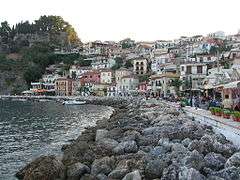
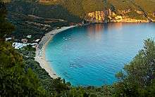
 View of Parga | |
 Parga Location within the region  | |
| Coordinates: 39°17′N 20°24′E | |
| Country | Greece |
| Administrative region | Epirus |
| Regional unit | Preveza |
| Government | |
| • Mayor | Nastas Antonios (since January 1, 2015) |
| Area | |
| • Municipality | 274.8 km2 (106.1 sq mi) |
| • Municipal unit | 68.9 km2 (26.6 sq mi) |
| Elevation | 32 m (105 ft) |
| Highest elevation | 910 m (2,990 ft) |
| Lowest elevation | 0 m (0 ft) |
| Population (2011)[1] | |
| • Municipality | 11,866 |
| • Municipality density | 43/km2 (110/sq mi) |
| • Municipal unit | 3,904 |
| • Municipal unit density | 57/km2 (150/sq mi) |
| Community | |
| • Population | 2,415 (2011) |
| Time zone | UTC+2 (EET) |
| • Summer (DST) | UTC+3 (EEST) |
| Postal code | 480 60 |
| Area code(s) | 26840 |
| Vehicle registration | ΡΖx |
| Website | parga.gr |
Municipality
The present municipality of Parga was formed at the 2011 local government reform by the merger of the following 2 former municipalities, that became municipal units:[2]
- Fanari
- Parga
The municipality has an area of 274.796 km2, the municipal unit 68.903 km2.[3]
History
In antiquity the area was inhabited by the Greek tribe of the Thesprotians. The ancient town of Toryne was probably located here.[4]
Parga itself is mentioned for the first time in 1318; the name is most likely of Slavic origin.[5] Two years later, the town and its sugarcane plantation proceeds were unsuccessfully offered by Nicholas Orsini, the Despot of Epirus, to the Republic of Venice in exchange for Venetian aid against the Byzantine Empire.[5] During the Epirote rebellion of 1338/39 against the Byzantine emperor Andronikos III Palaiologos, Parga remained loyal to the emperor.[5] In the 1390s it was under the rule of John Spata, lord of Arta.[5]
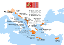
The town finally passed under Venetian control in 1401, and was administered as a mainland exclave of the Venetian possession of Corfu, under a castellan.[5] Venetian possession was confirmed in the Ottoman–Venetian treaty of 1419.[5] Apart from brief periods of Ottoman possession, the town remained in Venetian hands until the Fall of the Republic of Venice in 1797.[5]
In 1815, with the fortunes of the French failing, the citizens of Parga revolted against French rule and sought the protection of the British. In 1819, the British sold the city to Ali Pasha of Ioannina, and from him it passed under Ottoman rule.
Ottoman rule in Parga and the rest of Epirus was ended in 1913 following the victory of Greece in the Balkan Wars.[6]
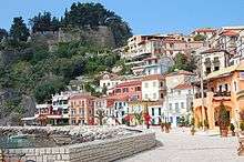
Castle of Parga
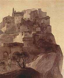
The Castle is found on the top of a hill overlooking the town and was used to protect the town from invasions from the mainland and the sea. It was initially built in the 11th century by the residents of Parga to protect their town from pirates and the Ottomans. In the 13th century, as their control of the region increased, the Venetians rebuilt the castle to fortify the area. In 1452, Parga and the castle were occupied by the Ottomans for two years; part of the castle was demolished at that time. In 1537, Ottoman admiral Hayreddin Barbarossa burned and destroyed the fortress and the houses within.
Before the reconstruction of the castle in 1572 by the Venetians, the Turks demolished it once again. The Venetians rebuilt it for the third and last time creating a stronger fortress that stayed impregnable until 1819, despite attacks, especially by Ali Pasha of Ioannina. Provisions for the castle were transported via two bays at Valtos and Pogonia. When Parga was sold to the Ottomans, Ali Pasha made structural additions to the castle, including a Turkish bath and his harem quarters which he built at the top of the fortress. On the arched gate at the wall of the castle entrance, the winged lion of Agios Markos is visible. Other entrance details include, the name “ANTONIO BERVASS 1764”, emblems of Ali Pasha, two-headed eagles and related inscriptions.[7]
Geography
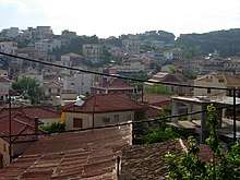
The city of Parga, built amphitheatrically, stands between the mountainous coastal region of Preveza and Igoumenitsa. It is known as the "Bride of Epirus". In the summer, tourists arrive from Paxos, Antipaxos, and Corfu by boat.[8]
Beaches
Parga attracts thousands of tourists. In its vicinity there are beaches including Valtos, Kryoneri, Piso Kryoneri, Lichnos, Sarakiniko and Ai Giannaki.[9]
Valtos Beach
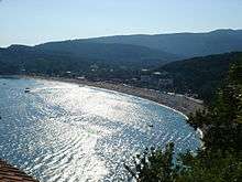
Valtos Beach is one of the best and longest beaches of Parga. It is located near the castle of Parga. Because of its clear waters and proximity to Parga it attracts many tourists.[10]
Krioneri Beach
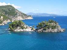
Krioneri Beach, the main beach of Parga, lies a short distance from the town centre. The small island of Virgin Mary is situated across the bay.[11]
Lichnos Beach
Lichnos Beach, one of the beaches of Parga,[12] is located in western Greece 3 km from Parga and Spread in the area of 2 hectares.[13]
Agios Sostis beach
Agios Sostis is a small beach on the northwest side of Anthoussa village. A small church, built in the 14th century, stands nearby.
Sarakiniko beach
Sarakiniko is a well-known beach, located on the west side of Agia village, near a small river and olive trees, approximately 12 km from the town centre. Small boats connect the beach with the port of Parga.
Transport
The town of Parga is linked with direct suburban buses (KTEL) to other Greek cities and towns such as Igoumenitsa[14] and Preveza.[15] There are also indirect connections with Athens. Thessaloniki and Ioannina[15][16]
Tourists arriving in Parga fly in from Aktio (65 km) with seasonal direct flights connecting Parga with Athens, Thessaloniki and other domestic and international destinations. Tourists also arrive via the Ioannina and Corfu airports.
Parga is located 10 km from national road ![]()
![]()
Municipal districts
- Agia (Agia, Sarakiniko)
- Anthousa (Anthousa, Trikorfo)
- Livadari (Livadari, Vryses)
- Parga (Parga, Agia Kyriaki, Agios Georgios, Maras, Chrysogiali)
Historical population
| Year | Town | Municipal unit | Municipality |
|---|---|---|---|
| 1981 | 1,892 | - | - |
| 1991 | 1,699 | 3,569 | - |
| 2001 | 2,432 | 4,033 | - |
| 2011 | 2,415 | 3,904 | 11,866 |
Notable people
- Pargalı Ibrahim Pasha (1493–1536), a grand vizier in the Ottoman Empire
- Andreas Idromenos (1764–1843), scholar
- Panagiotis Aravantinos (1811–1870), historian and scholar
- Ioannis Dimoulitsas, fighter of the Greek War of Independence
- TUS (1986), Greek rapper
References
| Wikivoyage has a travel guide for Parga. |
| Wikimedia Commons has media related to Parga. |
| Wikisource has the text of the 1911 Encyclopædia Britannica article Parga. |
- "Απογραφή Πληθυσμού - Κατοικιών 2011. ΜΟΝΙΜΟΣ Πληθυσμός" (in Greek). Hellenic Statistical Authority.
- "Kallikratis law" (PDF) (in Greek). Greece Ministry of Interior. Retrieved 2015-07-31.
- "Population & housing census 2001 (incl. area and average elevation)" (PDF) (in Greek). National Statistical Service of Greece.
-

- Soustal, Peter; Koder, Johannes (1981). Tabula Imperii Byzantini, Band 3: Nikopolis und Kephallēnia (in German). Vienna: Verlag der Österreichischen Akademie der Wissenschaften. pp. 226–227. ISBN 3-7001-0399-9.
- Archived December 5, 2011, at the Wayback Machine
- Archived August 28, 2011, at the Wayback Machine
- Archived August 27, 2011, at the Wayback Machine
- https://web.archive.org/web/20110827162735/http://www.parga.gr/site/?page_id=44&lang=en. Archived from the original on August 27, 2011. Retrieved November 13, 2011. Missing or empty
|title=(help) - https://web.archive.org/web/20110826024406/http://www.parga.gr/site/?page_id=46&lang=en. Archived from the original on August 26, 2011. Retrieved November 13, 2011. Missing or empty
|title=(help) - https://web.archive.org/web/20110828110343/http://www.parga.gr/site/?page_id=50&lang=en. Archived from the original on August 28, 2011. Retrieved November 13, 2011. Missing or empty
|title=(help) - "Beaches For Camping In Europe". Retrieved March 29, 2018.
- https://web.archive.org/web/20110825233321/http://www.parga.gr/site/?page_id=48&lang=en. Archived from the original on August 25, 2011. Retrieved November 30, 2011. Missing or empty
|title=(help) - "Αρχική Σελίδα". Ktel-thesprotias.gr. Retrieved 2015-07-30.
- "ΚΤΕΛ ΝΟΜΟΥ ΠΡΕΒΕΖΑΣ Α.Ε. :: Καλώς ήλθατε". Ktelprevezas.gr. Retrieved 2015-07-30.
- "йтек иыаммимым а.е". Ktelioannina.gr. Retrieved 2015-07-30.
| Regional unit of Arta |  | |
|---|---|---|
| Regional unit of Ioannina | ||
| Regional unit of Preveza | ||
| Regional unit of Thesprotia | ||
| ||
Stato da Màr of the Republic of Venice | ||
|---|---|---|
| Adriatic Sea |
|  |
| Ionian Islands and dependencies |
| |
| Mainland Greece |
| |
| Aegean Islands |
| |
| Other |
| |
| Related articles | ||