Monemvasia
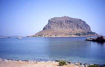
Monemvasia (Greek: Μονεμβασία) is a town and a municipality in Laconia, Greece. The town is located on a small island off the east coast of the Peloponnese. The island is linked to the mainland by a short causeway 200m in length. Its area consists mostly of a large plateau some 100 metres above sea level, up to 300 m wide and 1 km long, the site of a powerful medieval fortress. The town walls and many Byzantine churches remain from the medieval period. The seat of the municipality is the town Molaoi.[2]
Monemvasia Μονεμβασία | |
|---|---|
 Monemvasia island | |
 Monemvasia Location within the region 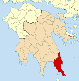 | |
| Coordinates: 36°41′N 23°3′E | |
| Country | Greece |
| Administrative region | Peloponnese |
| Regional unit | Laconia |
| Area | |
| • Municipality | 949.3 km2 (366.5 sq mi) |
| • Municipal unit | 209.0 km2 (80.7 sq mi) |
| Elevation | 15 m (49 ft) |
| Population (2011)[1] | |
| • Municipality | 21,942 |
| • Municipality density | 23/km2 (60/sq mi) |
| • Municipal unit | 4,041 |
| • Municipal unit density | 19/km2 (50/sq mi) |
| Community | |
| • Population | 1,418 (2011) |
| Time zone | UTC+2 (EET) |
| • Summer (DST) | UTC+3 (EEST) |
| Postal code | 230 70 |
| Area code(s) | 27320 |
| Vehicle registration | ΑΚ |
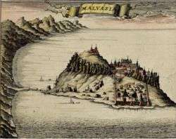
The town's name derives from two Greek words, mone and emvasia, meaning "single entrance". Its Italian form, Malvasia, gave its name to Malmsey wine. Monemvasia's nickname is the Gibraltar of the East or The Rock.
History
Early history
While uninhabited in antiquity, the rock may have been the site of a Minoan trading post. Pausanias, the renowned Greek traveler and geographer, referred to the site as "Akra Minoa", which translates to "Minoan Promontory".[3]
Byzantine, Venetian, Ottoman rule

The town and fortress were founded in 583 by inhabitants of the mainland seeking refuge from the Slavic and the Avaric invasion of Greece. A history of the invasion and occupation of the Peloponnese was recorded in the medieval Chronicle of Monemvasia.
From the 10th century AD, the town developed into an important trade and maritime centre. The fortress withstood the Arab and Norman invasions in 1147; farm fields that fed up to 30 men were tilled inside the fortress. William II of Villehardouin took it in 1248, on honourable terms, after three years of siege; in 1259 William was captured by the Greeks after the battle of Pelagonia and in 1262 it was retroceded to Michael VIII Palaiologos as part of William's ransom.
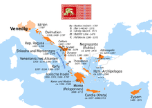
It remained part of the Byzantine Empire until 1460, becoming the seat of an imperial governor, a landing place for Byzantine operations against the Franks, the main port of shipment (if not always production) for Malmsey wine, and one of the most dangerous lairs of corsairs in the Levant. The Emperors gave it valuable privileges, attracting Roger de Lluria who sacked the lower town in 1292. The town welcomed the Catalan Company on its way eastward in 1302. In 1397 the Despot of the Morea, Theodore I Palaiologos, deposed the local dynast of Monemvasia, who appealed to Sultan Bayezid I and was reinstated by Turkish troops. In 1419 the rock appears to have come into the possession of Venice, though it soon returned to the Despot. About 1401, the historian George Sphrantzes was born in the town. After the fall of Constantinople in 1453 Monemvasia held out against the threats of Sultan Mehmed II in 1458 and 1460, when it became the only remaining domain of the Despot of the Morea, Thomas Palaiologos, claimant of the Imperial throne. He had no forces to defend it; he offered it to the Sultan, and finally sold it to the Pope.[4]
By 1464 the inhabitants found the Pope's representative feeble and the Pope unable to protect them; they admitted a Venetian garrison. The town was fairly prosperous under Venetian rule until the peace of 1502-3, in which it lost its farm lands, source of its food supply and of Malmsey wine. The food had to come by sea or from Turkish-held lands, and the cultivation of wine languished under Turkish rule. The rock was governed by the Venetians until the treaty of 1540, which cost the Republic Nauplia and Monemvasia, her last two possessions on mainland Greece. Those inhabitants who did not wish to live under Turkish rule were given lands elsewhere.[4] The Ottomans then ruled the town until the brief Venetian recovery in 1690, then again from 1715 to 1821. It was known as "Menekşe" ("Violet" in Turkish) during Ottoman rule and was a sanjak (province) centre in the Morea Eyalet.
The commercial importance of the town continued until the Orlov Revolt (1770) in the Russo-Turkish War, which saw its importance decline severely.
The town was liberated from Ottoman rule on July 23, 1821 by Tzannetakis Grigorakis who entered the town with his private army during the Greek War of Independence.
Today
In 1971, Monemvasia became linked with the rest of the outside world through a bridge on the western side that connects to GR-86.
In more recent history, the town has seen a resurgence in importance with increasing numbers of tourists visiting the site and the region. The medieval buildings have been restored, and many of them converted to hotels.
For the past few years, on July 23, an independence day celebration has been held in the main port. Speeches are made and the story of Tzannetakis Grigorakis, and his men, is recounted in both Greek and English. Inhabitants and visitors can gather to watch as a ship, built every year, is filled with pyrotechnics and set on fire.[5]
The 1986 horror movie The Wind was filmed here.
Historical population
| Year | Community | Municipal unit | Municipality |
|---|---|---|---|
| 1981 | 707 | - | - |
| 2001 | 1,405 | 4,660 | - |
| 2011 | 1,418 | 4,041 | 21,942 |
Municipality
The municipality of Monemvasia was formed during the 2011 local government reform, through the merger of the following 5 former municipalities, that became municipal units:[2]
The municipality has an area of 949.3 square kilometres (366.5 sq mi), the municipal unit an area of 209.0 square kilometres (80.7 sq mi).[6]
Geography
The island of Monemvasia was separated from the mainland by an earthquake in 375 AD. The majority of the island's area is a plateau about 100 metres above sea level, and the town of the same name is built on the slope to the south-east of the rock, overlooking Palaia Monemvasia bay. Many of the streets are narrow and fit only for pedestrian and donkey traffic. A small hamlet of about 10 houses lies to the northwest.
Climate
| Climate data for Monemvasia, Greece | |||||||||||||
|---|---|---|---|---|---|---|---|---|---|---|---|---|---|
| Month | Jan | Feb | Mar | Apr | May | Jun | Jul | Aug | Sep | Oct | Nov | Dec | Year |
| Average high °F (°C) | 58 (14) |
58 (14) |
61 (16) |
66 (19) |
72 (22) |
79 (26) |
83 (28) |
85 (29) |
81 (27) |
75 (24) |
67 (19) |
61 (16) |
70.5 (21.4) |
| Average low °F (°C) | 45 (7) |
45 (7) |
47 (8) |
52 (11) |
58 (14) |
65 (18) |
70 (21) |
71 (22) |
66 (19) |
60 (16) |
54 (12) |
48 (9) |
56.75 (13.75) |
Source: <World Weather Online >Monemvasia Monthly Climate Average, Greece. World Weather Online. 2016 http://www.worldweatheronline.com/monemvasia-weather-averages/peloponnese/gr.aspx. Retrieved 13 September 2016. Missing or empty |title= (help) | |||||||||||||
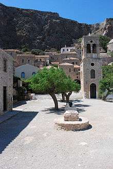
Places of interest
- Christos Elkomenos Square
- The church of Agia Sophia
- The fortress
Notable people
- Isidore of Kiev, Eastern (Greek) Catholic cardinal
- Loukas Notaras (d. 1453), last Byzantine Megas Doux
- Yiannis Ritsos (1909–1990), poet
Gallery
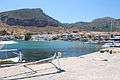 View of the port
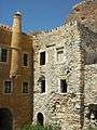 Venetian style house
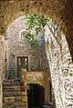 Old house
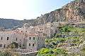 View to the fortress
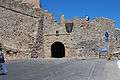 Entrance to the fortress
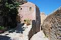 Street inside the fortress
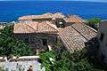 Rooftops
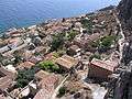 View of downtown
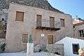 House and bust of Yiannis Ritsos
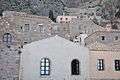 Traditional houses
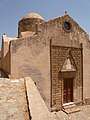 St Nicholas
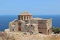 Church of Agia Sophia on top of the plateau
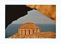 Agia Sophie
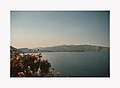 Mainland, from the top of the rock
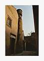 House in the kastro
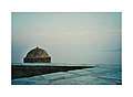 View from the kastro
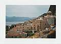 The kastro
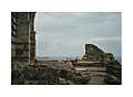 Ruines of Sainte Sophie, on the citadel
 Watchtower on the walls, citadel
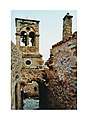 Bell tower, Kastro
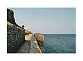 The walls along the sea, kastro
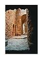 A street in the kastro
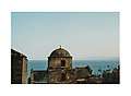 Dome in the kastro
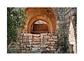 Sainte Sophie, citadel
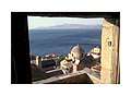 Balcony looking onto the sea
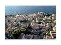 Early hours in the kastro
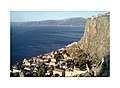 Early hours in the citadel
See also
References
- "Απογραφή Πληθυσμού - Κατοικιών 2011. ΜΟΝΙΜΟΣ Πληθυσμός" (in Greek). Hellenic Statistical Authority.
- Kallikratis law Greece Ministry of Interior (in Greek)
- Emke,Ellie. Discover Monemvasia: A guide to its past and present, Lichnos ltd, 1990, p,12.
- Miller, William (1907). "Monemvasia during the Frankish period 1204–1540". The Journal of Hellenic Studies: 229–241. doi:10.1017/S0075426900061607.
- "Events in Monemvasia". Monemvasiatour.com. Retrieved 27 February 2015.
- "Population & housing census 2001 (incl. area and average elevation)" (PDF) (in Greek). National Statistical Service of Greece.
Further reading
- Klaus, Rainer W., Steinmüller, Ulrich: Monemvasia. The Town and its History. English Version by Lawrence P. Buck. 9th, revised edition. Athens 2007
External links
| Wikimedia Commons has media related to Monemvasia. |
- Monemvasia | The official Tourism Website
- Monemvassia
- GTP - Monemvasia
- 360 Virtual Panoramic Photo Tour - Monemvasia Castle Walkthrough
Places adjacent to Monemvasia | ||||||||||
|---|---|---|---|---|---|---|---|---|---|---|
| ||||||||||
| Regional unit of Arcadia | 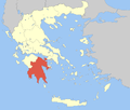 | |
|---|---|---|
| Regional unit of Argolis | ||
| Regional unit of Corinthia | ||
| Regional unit of Laconia |
| |
| Regional unit of Messenia | ||
| ||
Stato da Màr of the Republic of Venice | ||
|---|---|---|
| Adriatic Sea |
|  |
| Ionian Islands and dependencies |
| |
| Mainland Greece |
| |
| Aegean Islands |
| |
| Other |
| |
| Related articles | ||