Pallipuram Fort
Pallippuram Fort is a fort in Pallippuram, Vyppin, Ernakulam district of Kerala, south India. It was built by the Portuguese in 1503 and is the oldest existing European fort in India. The Dutch captured the fort in 1661 and sold it to the Kingdom of Travancore in 1789. The fort is situated in the northern extremity of Vypeen island and is hexagonal in shape, a form popularly known as ayikkotta or alikotta.[1]
| Pallippuram Fort | |
|---|---|
Paliport Castelo en Cima (Top Castle) | |
| Pallippuram, Vyppin, Ernakulam district | |
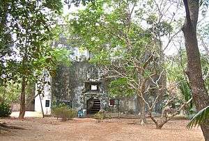 Ruins of the Portuguese fort in Vyppin | |
 Pallippuram Fort | |
| Coordinates | 10.170°N 76.180°E |
| Type | Island fort |
| Site information | |
| Owner | Government of Kerala |
| Controlled by |
|
| Open to the public | Yes |
| Condition | Structure |
| Site history | |
| Built | 1503 |
| Materials | Stone |
Structure
Hexagonal in shape, the lowest internal floor of the fort is raised to a height of 5 feet (1.5 m). The gate and the door posts, and the lintels are finely dressed and arched while underground there is a cellar that was used to store gunpowder. A 3.25 by 3.25 feet (0.99 m × 0.99 m) well provided a source of fresh water.
There is an opening to the north which leads to the cellar. There is a circular slab stone, on which was installed a pillar on which the radiating wooden struts supporting the upper two floors must have rested.
Each face of the fort measures 32 feet (9.8 m) long and 34 feet (10 m) high while the walls are six feet thick. Each face of the fort has three embrasures, one above the other. The central opening of the embrasures measures 2 by 2.5 feet (0.61 m × 0.76 m). The fort could have mounted as many as guns commanding all quarters round it. There is an open space inside affording easy passage to the cellar.
The fort is constructed using laterite, chunam, and wood. The walls are thickly plastered using mortar. The door way in the central circular slab is made of granite. All the six sides of the fort are overgrown with vegetation.
It have an underground path which connects some other openings of them. It was saying that the route goes under rivers and lands which they used to escape from enemies when needed. And still not pretty sure of that what all things are on the way, maybe some treasures or anything else. Underground way is permanently closed now.
Gallery
 Information board
.jpg) Inner area of ayakotta
Inner area of ayakotta
References
- "Monuments at a Glance". Government of Kerala. Archived from the original on 22 December 2004. Retrieved 24 February 2014.
External links
| Wikimedia Commons has media related to Pallipuram Fort. |
| Vijayanagara | |
|---|---|
| Deccan sultanates | |
| Gujarat Sultanate | |
| Delhi Sultanate | |
| Nayak dynasty | |
| Malwa Sultanate | |
| Faruqi dynasty | |
| Rajputs | |
| Maratha Empire | |
| Mughal Empire | |
| Jat | |
| Kingdom of Mysore | |
| Siddi | |
| Travancore | |
| Portuguese |
|
| Sikh Empire | |
| British Raj |
|
| Sur Empire | |
| Ahom dynasty | |
| Kakatiya dynasty | |
| Bahmani Sultanate | |